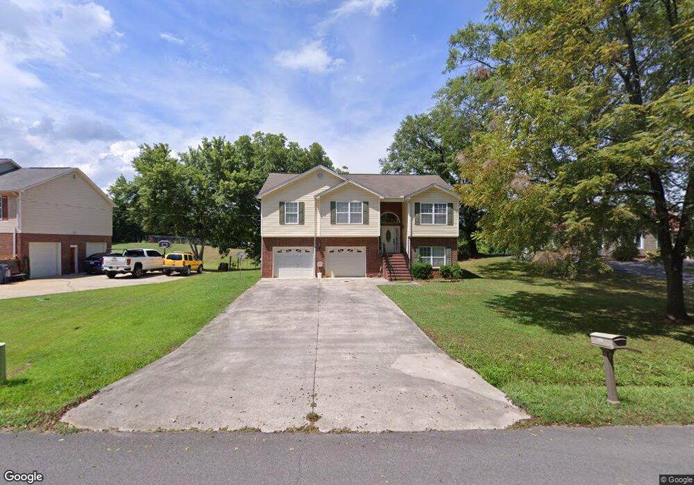
3843 Brock Rd SE Dalton, GA 30721
Estimated Value: $231,545 - $265,000
3
Beds
3
Baths
1,457
Sq Ft
$172/Sq Ft
Est. Value
About This Home
This home is located at 3843 Brock Rd SE, Dalton, GA 30721 and is currently estimated at $250,386, approximately $171 per square foot. 3843 Brock Rd SE is a home located in Whitfield County with nearby schools including Cedar Ridge Elementary School, Eastbrook Middle School, and Southeast Whitfield County High School.
Ownership History
Date
Name
Owned For
Owner Type
Purchase Details
Closed on
Jun 20, 2008
Sold by
Deutsche Bank National Tru
Bought by
Lopez Efrain
Current Estimated Value
Purchase Details
Closed on
Feb 5, 2008
Sold by
Not Provided
Bought by
Lopez Efrain
Purchase Details
Closed on
May 1, 2003
Sold by
White Sherrill
Bought by
Gonzalez Goldardo
Purchase Details
Closed on
Aug 23, 2002
Bought by
White Sherrill
Create a Home Valuation Report for This Property
The Home Valuation Report is an in-depth analysis detailing your home's value as well as a comparison with similar homes in the area
Home Values in the Area
Average Home Value in this Area
Purchase History
| Date | Buyer | Sale Price | Title Company |
|---|---|---|---|
| Lopez Efrain | $123,000 | -- | |
| Lopez Efrain | $111,200 | -- | |
| Gonzalez Goldardo | $130,000 | -- | |
| White Sherrill | $39,000 | -- |
Source: Public Records
Tax History Compared to Growth
Tax History
| Year | Tax Paid | Tax Assessment Tax Assessment Total Assessment is a certain percentage of the fair market value that is determined by local assessors to be the total taxable value of land and additions on the property. | Land | Improvement |
|---|---|---|---|---|
| 2024 | $1,660 | $85,940 | $4,936 | $81,004 |
| 2023 | $1,660 | $60,080 | $3,233 | $56,847 |
| 2022 | $1,213 | $49,667 | $3,173 | $46,494 |
| 2021 | $1,213 | $49,667 | $3,173 | $46,494 |
| 2020 | $1,243 | $49,667 | $3,173 | $46,494 |
| 2019 | $1,257 | $49,667 | $3,173 | $46,494 |
| 2018 | $1,256 | $49,165 | $2,671 | $46,494 |
| 2017 | $1,257 | $49,165 | $2,671 | $46,494 |
| 2016 | $1,094 | $44,957 | $2,671 | $42,286 |
| 2014 | $1,018 | $45,200 | $2,914 | $42,286 |
| 2013 | -- | $45,199 | $2,913 | $42,286 |
Source: Public Records
Map
Nearby Homes
- 01 Headrick Cir SE
- 00 Headrick Cir SE
- 3657 Airport Rd
- 760 Keith Rd SE
- 4322 Banks Dr SE
- 185 Cedar Ridge Rd
- 1142 Ben Hill Rd SE
- 4386 Tibbs Bridge Rd SE
- 0 Tibbs Bridge Rd SE
- 2200 Ridge Rd SE
- 00 Tibbs Bridge Rd
- 296 Wagner Dr
- 741 North Dr SE
- 1271 Ridge Rd SE
- 279 Satterfield Rd SE
- 00 Hill Rd
- TBD Old Grade Rd
- 0 Old Grade Rd
- 404 Lakeview Dr SE
- 1401 Eastbrook Dr SE
- 3839 Brock Rd SE
- 3847 Brock Rd SE
- 3835 Brock Rd SE
- 3831 Brock Rd SE
- 166 Jericho Way
- 3821 Brock Rd SE
- 0 Brock Rd SE Unit 3267602
- 0 Brock Rd SE Unit 5050366
- 0 Brock Rd SE Unit 80018
- 00 Brock Rd SE
- 3817 Brock Rd SE
- 3853 Brock Rd SE
- 3819 Brock Rd SE
- 3851 Brock Rd SE
- 3815 Brock Rd SE
- 3849 Brock Rd SE
- 3816 Brock Rd SE
- 3811 Brock Rd SE
- 310 Jericho Way
- 3812 Brock Rd SE