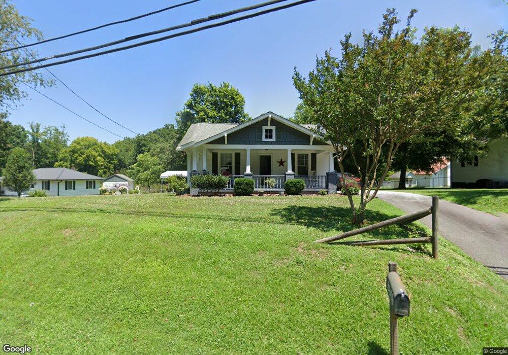
3845 High Point Rd Winston Salem, NC 27107
Estimated Value: $154,560 - $202,000
2
Beds
1
Bath
966
Sq Ft
$180/Sq Ft
Est. Value
About This Home
This home is located at 3845 High Point Rd, Winston Salem, NC 27107 and is currently estimated at $174,140, approximately $180 per square foot. 3845 High Point Rd is a home located in Forsyth County with nearby schools including Hall-Woodward Elementary School, Southeast Middle School, and R.B. Glenn High School.
Ownership History
Date
Name
Owned For
Owner Type
Purchase Details
Closed on
Dec 18, 2001
Sold by
Miller Nathaniel E and Miller Louanne L
Bought by
Harrold Denise
Current Estimated Value
Home Financials for this Owner
Home Financials are based on the most recent Mortgage that was taken out on this home.
Original Mortgage
$66,431
Outstanding Balance
$25,823
Interest Rate
6.5%
Mortgage Type
FHA
Estimated Equity
$148,317
Create a Home Valuation Report for This Property
The Home Valuation Report is an in-depth analysis detailing your home's value as well as a comparison with similar homes in the area
Home Values in the Area
Average Home Value in this Area
Purchase History
| Date | Buyer | Sale Price | Title Company |
|---|---|---|---|
| Harrold Denise | $67,000 | -- |
Source: Public Records
Mortgage History
| Date | Status | Borrower | Loan Amount |
|---|---|---|---|
| Open | Harrold Denise | $66,431 |
Source: Public Records
Tax History Compared to Growth
Tax History
| Year | Tax Paid | Tax Assessment Tax Assessment Total Assessment is a certain percentage of the fair market value that is determined by local assessors to be the total taxable value of land and additions on the property. | Land | Improvement |
|---|---|---|---|---|
| 2025 | $635 | $105,600 | $36,500 | $69,100 |
| 2024 | $606 | $81,500 | $36,500 | $45,000 |
| 2023 | $606 | $81,500 | $36,500 | $45,000 |
| 2022 | $595 | $81,500 | $36,500 | $45,000 |
| 2021 | $584 | $81,500 | $36,500 | $45,000 |
| 2020 | $509 | $61,900 | $25,700 | $36,200 |
| 2019 | $513 | $61,900 | $25,700 | $36,200 |
| 2018 | $487 | $61,900 | $25,700 | $36,200 |
| 2016 | $455 | $62,467 | $24,368 | $38,099 |
| 2015 | $448 | $62,467 | $24,368 | $38,099 |
| 2014 | $484 | $62,467 | $24,368 | $38,099 |
Source: Public Records
Map
Nearby Homes
- 2981 Durant Dr
- 2983 Durant Dr
- Ashe Plan at Robindale
- Erie Plan at Robindale
- Camden Plan at Robindale
- Durham Plan at Robindale
- Avery Plan at Robindale
- Cary Plan at Robindale
- Carolina Plan at Robindale
- 3598 Robindale Dr
- 3471 Robindale Dr
- 3458 Robindale Dr
- 3453 Robindale Dr
- 421 Robindale Ct
- 3447 Robindale Dr
- 3441 Robindale Dr
- 6080 Yeaton Glen Dr
- 3435 Robindale Dr
- 3428 Robindale Dr
- 3422 Robindale Dr
- 3849 High Point Rd
- 3851 High Point Rd
- 3835 High Point Rd
- 3850 High Point Rd
- 0 Meadowood
- 3828 High Point Rd
- 3861 High Point Rd
- 3820 High Point Rd
- 3900 Magnolia Place Ln
- 3906 Magnolia Place Ln
- 3912 Magnolia Place Ln
- 2910 Durant Dr
- 3906 High Point Rd
- 3816 High Point Rd
- 3918 Magnolia Place Ln
- 3924 Magnolia Place Ln
- 3812 High Point Rd
- 3813 High Point Rd
- 0 Magnolia Place Ln
- 11 Magnolia Place Ln