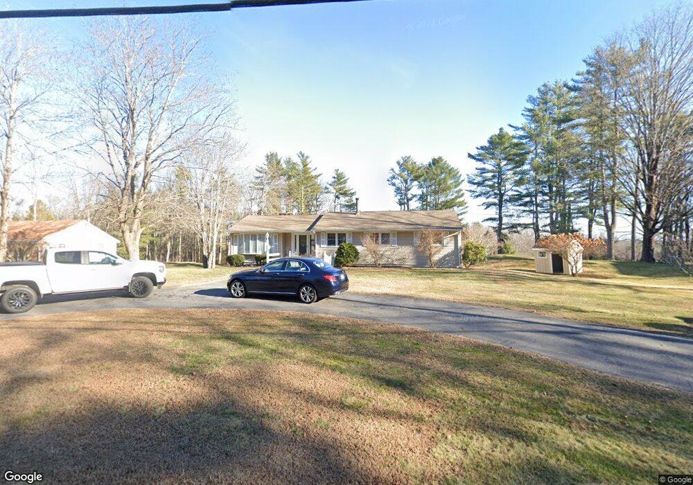
385 Methodist Rd Westbrook, ME 04092
Estimated Value: $437,670 - $525,000
3
Beds
1
Bath
1,405
Sq Ft
$350/Sq Ft
Est. Value
About This Home
This home is located at 385 Methodist Rd, Westbrook, ME 04092 and is currently estimated at $491,668, approximately $349 per square foot. 385 Methodist Rd is a home located in Cumberland County with nearby schools including Westbrook High School and Breakwater School.
Ownership History
Date
Name
Owned For
Owner Type
Purchase Details
Closed on
Oct 18, 2022
Sold by
Arnold Opal M
Bought by
Vaillancourt Roger G
Current Estimated Value
Purchase Details
Closed on
Apr 12, 2005
Sold by
Valliancourt Roger G
Bought by
Vaillancourt Roger G and Arnold Opal M
Home Financials for this Owner
Home Financials are based on the most recent Mortgage that was taken out on this home.
Original Mortgage
$87,500
Interest Rate
5%
Mortgage Type
Adjustable Rate Mortgage/ARM
Create a Home Valuation Report for This Property
The Home Valuation Report is an in-depth analysis detailing your home's value as well as a comparison with similar homes in the area
Home Values in the Area
Average Home Value in this Area
Purchase History
| Date | Buyer | Sale Price | Title Company |
|---|---|---|---|
| Vaillancourt Roger G | -- | None Available | |
| Vaillancourt Roger G | -- | -- |
Source: Public Records
Mortgage History
| Date | Status | Borrower | Loan Amount |
|---|---|---|---|
| Previous Owner | Vaillancourt Roger G | $87,500 |
Source: Public Records
Tax History
| Year | Tax Paid | Tax Assessment Tax Assessment Total Assessment is a certain percentage of the fair market value that is determined by local assessors to be the total taxable value of land and additions on the property. | Land | Improvement |
|---|---|---|---|---|
| 2023 | $4,545 | $272,500 | $80,600 | $191,900 |
| 2022 | $4,114 | $227,300 | $67,200 | $160,100 |
| 2021 | $4,053 | $227,300 | $67,200 | $160,100 |
| 2020 | $4,060 | $227,300 | $67,200 | $160,100 |
| 2019 | $335 | $227,300 | $67,200 | $160,100 |
| 2018 | $330 | $198,400 | $58,500 | $139,900 |
| 2017 | $3,746 | $198,400 | $58,500 | $139,900 |
| 2016 | $331 | $198,400 | $58,500 | $139,900 |
| 2015 | $3,563 | $198,400 | $58,500 | $139,900 |
| 2014 | $3,412 | $198,400 | $58,500 | $139,900 |
| 2013 | $3,412 | $198,400 | $58,500 | $139,900 |
Source: Public Records
Map
Nearby Homes
- 680 Methodist Rd
- 7 Collins Place Unit 6
- 18 Summit Cir
- 22 Collins Place Dr Unit 4
- 30 Fawn Woods Way Unit 30
- 3 Collins Place Unit 5
- 7 Apex Dr Unit 2
- 5 Apex Dr Unit 1
- 67 Brydon Way Unit 70
- 176 Carlson St
- 6 Crestwood Dr
- 290 Bridgton Rd Unit 1
- 26 Stillwater Dr Unit 26
- 89 Duck Pond Rd
- 169 Brook St
- 171 Brook St Unit 49
- 171 Brook St Unit 44
- 171 Brook St Unit 50
- 171 Brook St Unit 3
- 171 Brook St Unit 52
- 391 Methodist Rd
- 379 Methodist Rd
- 397 Methodist Rd
- 343 Methodist Rd
- 390 Methodist Rd
- 405 Methodist Rd
- 472 Methodist Rd
- 333 Methodist Rd
- 461 Methodist Rd
- 315 Methodist Rd
- 478 Methodist Rd
- 320 Methodist Rd
- 463 Methodist Rd
- 473 Methodist Rd
- 482 Methodist Rd
- 3 Perry Ct
- 5 Perry Ct
- 2 Perry Ct
- Lot 2-A Perry
- Lot 2-B Perry Ct
Your Personal Tour Guide
Ask me questions while you tour the home.