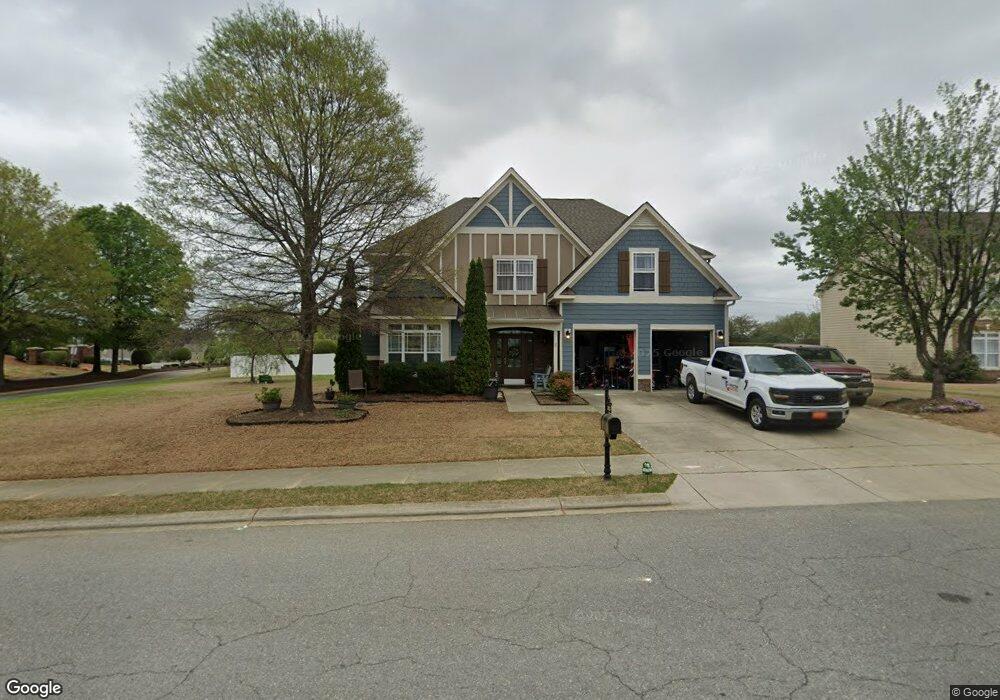
386 Adams Point Dr Garner, NC 27529
Estimated Value: $529,963 - $562,000
5
Beds
4
Baths
3,232
Sq Ft
$170/Sq Ft
Est. Value
About This Home
This home is located at 386 Adams Point Dr, Garner, NC 27529 and is currently estimated at $548,991, approximately $169 per square foot. 386 Adams Point Dr is a home located in Johnston County with nearby schools including West View Elementary School, Cleveland Middle School, and West Johnston High School.
Ownership History
Date
Name
Owned For
Owner Type
Purchase Details
Closed on
Feb 14, 2018
Sold by
Stroud Leland Shaun
Bought by
Cox Alicia D and Cox Robert J
Current Estimated Value
Home Financials for this Owner
Home Financials are based on the most recent Mortgage that was taken out on this home.
Original Mortgage
$248,000
Outstanding Balance
$206,385
Interest Rate
3.95%
Mortgage Type
New Conventional
Estimated Equity
$342,606
Purchase Details
Closed on
Apr 1, 2008
Sold by
Southpoint Homes Llc
Bought by
Stroud Leland Shaun
Home Financials for this Owner
Home Financials are based on the most recent Mortgage that was taken out on this home.
Original Mortgage
$277,643
Interest Rate
5.84%
Mortgage Type
FHA
Purchase Details
Closed on
Jul 10, 2007
Sold by
Son Lan Development Co Inc
Bought by
Southpoint Homes Llc and Scenic Homes
Create a Home Valuation Report for This Property
The Home Valuation Report is an in-depth analysis detailing your home's value as well as a comparison with similar homes in the area
Home Values in the Area
Average Home Value in this Area
Purchase History
We collect this data history from publicly available records. To have your information removed, we recommend requesting removal directly through your county’s website.
| Date | Buyer | Sale Price | Title Company |
|---|---|---|---|
| Cox Alicia D | $315,000 | None Available | |
| Stroud Leland Shaun | $282,000 | None Available | |
| Southpoint Homes Llc | $1,062,500 | None Available |
Source: Public Records
Mortgage History
We collect this data history from publicly available records. To have your information removed, we recommend requesting removal directly through your county’s website.
| Date | Status | Borrower | Loan Amount |
|---|---|---|---|
| Open | Cox Alicia D | $248,000 | |
| Previous Owner | Stroud Leland Shaun | $277,643 |
Source: Public Records
Tax History
| Year | Tax Paid | Tax Assessment Tax Assessment Total Assessment is a certain percentage of the fair market value that is determined by local assessors to be the total taxable value of land and additions on the property. | Land | Improvement |
|---|---|---|---|---|
| 2025 | $3,307 | $520,750 | $70,000 | $450,750 |
| 2024 | $2,677 | $330,540 | $48,000 | $282,540 |
| 2023 | $2,586 | $330,540 | $48,000 | $282,540 |
| 2022 | $2,719 | $330,540 | $48,000 | $282,540 |
| 2021 | $2,694 | $327,520 | $48,000 | $279,520 |
| 2020 | $2,727 | $327,520 | $48,000 | $279,520 |
| 2019 | $2,727 | $327,520 | $48,000 | $279,520 |
| 2018 | $2,595 | $304,420 | $44,000 | $260,420 |
| 2017 | $2,595 | $304,420 | $44,000 | $260,420 |
| 2016 | $2,595 | $304,420 | $44,000 | $260,420 |
| 2015 | $2,595 | $304,420 | $44,000 | $260,420 |
| 2014 | $2,595 | $304,420 | $44,000 | $260,420 |
Source: Public Records
Map
Nearby Homes
- 58 Trailblazer Ln
- 267 Meadowmist Dr
- 13 W Currituck Cir
- 210 Ivey Gate Ln
- 320 Black Angus Dr
- 36 Miry Branch Ct
- 41 Gladwood Way
- 188 Flight Pattern Way
- 222 Dana Dr
- 125 Wolf Den Dr
- 17 Belgian Blue Dr
- 908 Olive Dr
- 304 Artic Cir
- 0 Southfort Dr
- 500 Hillcrest Dr
- Lot 2a S Shiloh Rd
- 2012 Southfort Dr
- 121 Telluride Trail
- 113 Linden Ct
- 97 Fairbanks Ave
- 368 Adams Point Dr
- 346 Adams Point Dr
- 428 Adams Point Dr
- 391 Adams Point Dr
- 45 Leachburg Dr
- 5 Leachburg Dr
- 373 Adams Point Dr
- 101 Leachburg Dr
- 1511 Old Drug Store Rd
- 1555 Old Drug Store Rd
- 450 Adams Point Dr
- 429 Adams Point Dr
- 328 Adams Point Dr
- 351 Adams Point Dr
- 100 Leachburg Dr
- 46 Leachburg Dr
- 2 Leachburg Dr
- 26 Leachburg Dr
- 331 Adams Point Dr
- 447 Adams Point Dr Unit CARLO
Your Personal Tour Guide
Ask me questions while you tour the home.