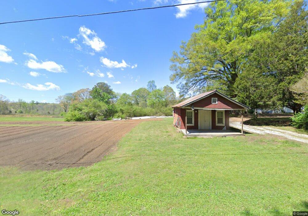
386 Highway 201 La Fayette, GA 30728
Estimated Value: $426,000 - $758,357
--
Bed
--
Bath
976
Sq Ft
$607/Sq Ft
Est. Value
About This Home
This home is located at 386 Highway 201, La Fayette, GA 30728 and is currently estimated at $592,179, approximately $606 per square foot. 386 Highway 201 is a home located in Walker County with nearby schools including Naomi Elementary School, Lafayette Middle School, and Lafayette High School.
Ownership History
Date
Name
Owned For
Owner Type
Purchase Details
Closed on
Sep 28, 2021
Sold by
Beavers Amie H
Bought by
Beavers Danny and Beavers Lisa
Current Estimated Value
Purchase Details
Closed on
Mar 4, 2016
Sold by
Hammontree Judy M
Bought by
Beavers Amie H
Purchase Details
Closed on
May 15, 2015
Sold by
Hammontree William Michael
Bought by
Hammontree Judy M
Purchase Details
Closed on
Feb 26, 2006
Sold by
Not Provided
Bought by
Hammontree William Michael
Purchase Details
Closed on
Apr 28, 1999
Sold by
Hammontree D F Macie Mrs
Bought by
Hammontree Max
Purchase Details
Closed on
Jan 1, 1972
Bought by
Hammontree D F Macie Mrs
Create a Home Valuation Report for This Property
The Home Valuation Report is an in-depth analysis detailing your home's value as well as a comparison with similar homes in the area
Home Values in the Area
Average Home Value in this Area
Purchase History
| Date | Buyer | Sale Price | Title Company |
|---|---|---|---|
| Beavers Danny | -- | -- | |
| Beavers Amie H | -- | -- | |
| Hammontree Judy M | -- | -- | |
| Hammontree William Michael | -- | -- | |
| Hammontree Max | -- | -- | |
| Hammontree D F Macie Mrs | -- | -- |
Source: Public Records
Tax History Compared to Growth
Tax History
| Year | Tax Paid | Tax Assessment Tax Assessment Total Assessment is a certain percentage of the fair market value that is determined by local assessors to be the total taxable value of land and additions on the property. | Land | Improvement |
|---|---|---|---|---|
| 2024 | $5,235 | $293,699 | $91,597 | $202,102 |
| 2023 | $5,046 | $264,246 | $72,696 | $191,550 |
| 2022 | $4,661 | $207,821 | $42,673 | $165,148 |
| 2021 | $4,435 | $187,457 | $52,159 | $135,298 |
| 2020 | $3,827 | $159,467 | $52,159 | $107,308 |
| 2019 | $3,883 | $159,467 | $52,159 | $107,308 |
| 2018 | $4,220 | $159,467 | $52,159 | $107,308 |
| 2017 | $4,327 | $159,467 | $52,159 | $107,308 |
| 2016 | $1,002 | $51,529 | $38,231 | $13,298 |
| 2015 | $977 | $39,235 | $26,592 | $12,643 |
| 2014 | $765 | $39,235 | $26,592 | $12,643 |
| 2013 | -- | $39,235 | $26,592 | $12,643 |
Source: Public Records
Map
Nearby Homes
- 349 Joe Robertson Rd
- 00 Joe Robertson Rd
- 4177 S Jimmy Dr
- 4180 S Jimmy Dr
- 0 Clement Rd Unit 7454770
- 0 Clement Rd Unit 10376510
- 721 Gowan Rd
- 4744 N Jimmy Dr
- 297 Townsend Rd
- 0 Townsend Rd
- 1166 Lower Mill Creek Rd
- 124 Jonathan Way
- 2950 Davis Rd
- 2906 Davis Rd
- 110 Windy Hill Dr
- 9724 Georgia 136
- Tract 1 A & B I-75 Beavers Rd
- 1446 Lafayette Rd
- 1005 Robin Way
- 2708 Quarles Rd