Estimated Value: $736,997 - $857,000
4
Beds
3
Baths
2,214
Sq Ft
$355/Sq Ft
Est. Value
About This Home
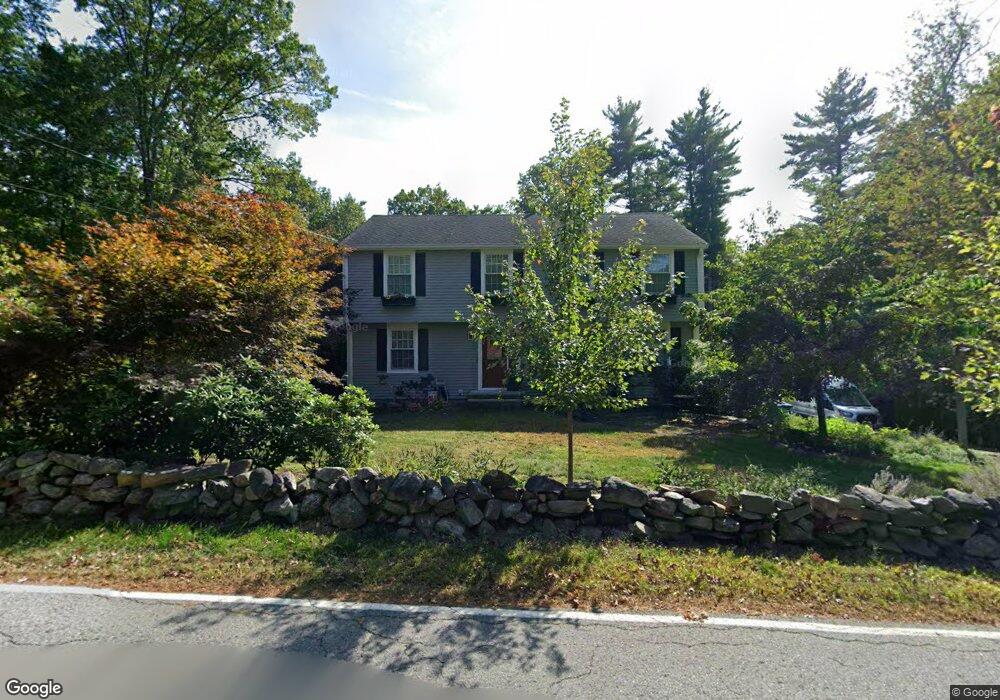
This home is located at 386 Taylor Rd, Stow, MA 01775 and is currently estimated at $786,999, approximately $355 per square foot. 386 Taylor Rd is a home located in Middlesex County with nearby schools including Center School, Hale Middle School, and Nashoba Regional High School.
Ownership History
Date
Name
Owned For
Owner Type
Purchase Details
Closed on
Apr 11, 2011
Sold by
Vyas Aditya and Vyas Veera
Bought by
Blough Robert T and Blough Lisa L
Current Estimated Value
Home Financials for this Owner
Home Financials are based on the most recent Mortgage that was taken out on this home.
Original Mortgage
$319,900
Outstanding Balance
$17,406
Interest Rate
4.99%
Mortgage Type
Purchase Money Mortgage
Estimated Equity
$769,593
Purchase Details
Closed on
Dec 23, 2008
Sold by
Couture Jean
Bought by
Vyas Aditya and Vyas Veera
Home Financials for this Owner
Home Financials are based on the most recent Mortgage that was taken out on this home.
Original Mortgage
$346,770
Interest Rate
6.27%
Mortgage Type
Purchase Money Mortgage
Purchase Details
Closed on
Nov 20, 2008
Sold by
Lawrence Peter D
Bought by
Couture Jean
Home Financials for this Owner
Home Financials are based on the most recent Mortgage that was taken out on this home.
Original Mortgage
$346,770
Interest Rate
6.27%
Mortgage Type
Purchase Money Mortgage
Create a Home Valuation Report for This Property
The Home Valuation Report is an in-depth analysis detailing your home's value as well as a comparison with similar homes in the area
Home Values in the Area
Average Home Value in this Area
Purchase History
| Date | Buyer | Sale Price | Title Company |
|---|---|---|---|
| Blough Robert T | $399,900 | -- | |
| Vyas Aditya | $385,300 | -- | |
| Couture Jean | -- | -- |
Source: Public Records
Mortgage History
| Date | Status | Borrower | Loan Amount |
|---|---|---|---|
| Open | Blough Robert T | $319,900 | |
| Previous Owner | Vyas Aditya | $346,770 |
Source: Public Records
Tax History
| Year | Tax Paid | Tax Assessment Tax Assessment Total Assessment is a certain percentage of the fair market value that is determined by local assessors to be the total taxable value of land and additions on the property. | Land | Improvement |
|---|---|---|---|---|
| 2025 | $10,652 | $611,500 | $339,300 | $272,200 |
| 2024 | $11,319 | $667,000 | $373,100 | $293,900 |
| 2023 | $10,457 | $576,800 | $333,500 | $243,300 |
| 2022 | $9,066 | $463,500 | $256,800 | $206,700 |
| 2021 | $9,345 | $467,700 | $256,800 | $210,900 |
| 2020 | $8,324 | $403,900 | $236,900 | $167,000 |
| 2019 | $7,927 | $393,800 | $236,900 | $156,900 |
| 2018 | $7,737 | $368,800 | $236,900 | $131,900 |
| 2017 | $7,499 | $364,200 | $211,100 | $153,100 |
| 2016 | $7,257 | $363,200 | $211,100 | $152,100 |
| 2015 | $7,101 | $355,400 | $191,900 | $163,500 |
Source: Public Records
Map
Nearby Homes
- 53 Sylvan Dr
- 13 Pine Hill Way
- 77 Wheeler Dr Unit 77
- 20 Lyons Ln Unit 20
- 14 Pine Hill Way
- 18 B Pine Hill Way Unit BB
- 310 Codman Hill Rd Unit 35D
- 30-6 Taylor Rd
- 9 Cortland Dr Unit 9
- 54 Orchard Dr Unit 54
- 414 Great Rd
- 247 W Acton Rd
- 15 Crescent St
- 53 Swanson Ct Unit 24C
- 94 Hudson Rd
- 176 Swanson Rd Unit 304
- 220 Swanson Rd Unit 605
- 220 Swanson Rd Unit 606
- 220 Swanson Rd Unit 604
- 90 Corn Rd
Your Personal Tour Guide
Ask me questions while you tour the home.