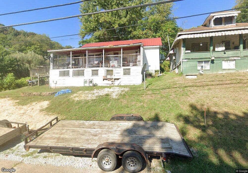
38647 State Route 7 Sardis, OH 43946
Estimated Value: $35,000 - $119,000
--
Bed
1
Bath
935
Sq Ft
$89/Sq Ft
Est. Value
About This Home
This home is located at 38647 State Route 7, Sardis, OH 43946 and is currently estimated at $83,555, approximately $89 per square foot. 38647 State Route 7 is a home located in Monroe County with nearby schools including River Elementary School and River High School.
Ownership History
Date
Name
Owned For
Owner Type
Purchase Details
Closed on
Nov 22, 2022
Sold by
Hoskinson Gary Lee and Hoskinson Nancy Marie
Bought by
Stewart-Hoskinson Revocable Trust
Current Estimated Value
Purchase Details
Closed on
Aug 23, 2022
Sold by
Wilt Robert Douglas
Bought by
Hoskinson Nancy M
Purchase Details
Closed on
Jun 16, 2008
Sold by
Wohnhas Dean A
Bought by
Whittington Brenda
Purchase Details
Closed on
Feb 26, 2002
Bought by
Wilt Robert D
Create a Home Valuation Report for This Property
The Home Valuation Report is an in-depth analysis detailing your home's value as well as a comparison with similar homes in the area
Home Values in the Area
Average Home Value in this Area
Purchase History
| Date | Buyer | Sale Price | Title Company |
|---|---|---|---|
| Stewart-Hoskinson Revocable Trust | -- | -- | |
| Stewart-Hoskinson Revocable Trust | -- | None Listed On Document | |
| Hoskinson Nancy M | -- | -- | |
| Whittington Brenda | $28,000 | -- | |
| Wilt Robert D | -- | -- |
Source: Public Records
Tax History Compared to Growth
Tax History
| Year | Tax Paid | Tax Assessment Tax Assessment Total Assessment is a certain percentage of the fair market value that is determined by local assessors to be the total taxable value of land and additions on the property. | Land | Improvement |
|---|---|---|---|---|
| 2024 | $317 | $11,160 | $2,730 | $8,430 |
| 2023 | $317 | $11,160 | $2,730 | $8,430 |
| 2022 | $317 | $11,160 | $2,730 | $8,430 |
| 2021 | $301 | $10,510 | $2,270 | $8,240 |
| 2020 | $301 | $10,510 | $2,270 | $8,240 |
| 2019 | $301 | $10,510 | $2,270 | $8,240 |
| 2018 | $450 | $9,740 | $1,890 | $7,850 |
| 2017 | $291 | $9,740 | $1,890 | $7,850 |
| 2016 | $295 | $9,740 | $1,890 | $7,850 |
| 2015 | $266 | $8,300 | $1,520 | $6,780 |
| 2014 | $266 | $8,300 | $1,520 | $6,780 |
| 2013 | $260 | $7,550 | $980 | $6,570 |
Source: Public Records
Map
Nearby Homes
- 210 Ack Ferry Adn
- 601 4th St
- 180 Pike St
- 270 Duerr St
- 337 Mceldowney Ave
- 653 6th St
- 735 5th St
- 803 5th St
- 807 5th St
- 405 Edgewood Terrace
- 46 W Rolling Acres Rd
- 37311 Willow St
- 37370 5th Ave
- 37283 Border St
- 52100 State Route 536
- 0 Lot 2 Country Blvd
- 37020 Monroe St
- 0 Country Blvd Unit 5119547
- 296 N State Route 2
- 290 Pleasants Valley Rd
- 38657 State Route 7
- 52765 Fry Hill Rd
- 38669 State Route 7
- 38679 State Route 7
- 38668 State Route 7
- 38707 State Route 7
- 38573 State Route 7
- 38712 State Route 7
- 52758 Fry Hill Rd
- 38571 State Route 7
- 38721 State Route 7
- 38565 State Route 7
- 38585 State Route 7
- 38739 State Route 7
- 38730 State Route 7
- 38547 State Route 7
- 38698 State Route 7
- 38744 State Route 7
- 38763 State Route 7
- 38548 State Route 7