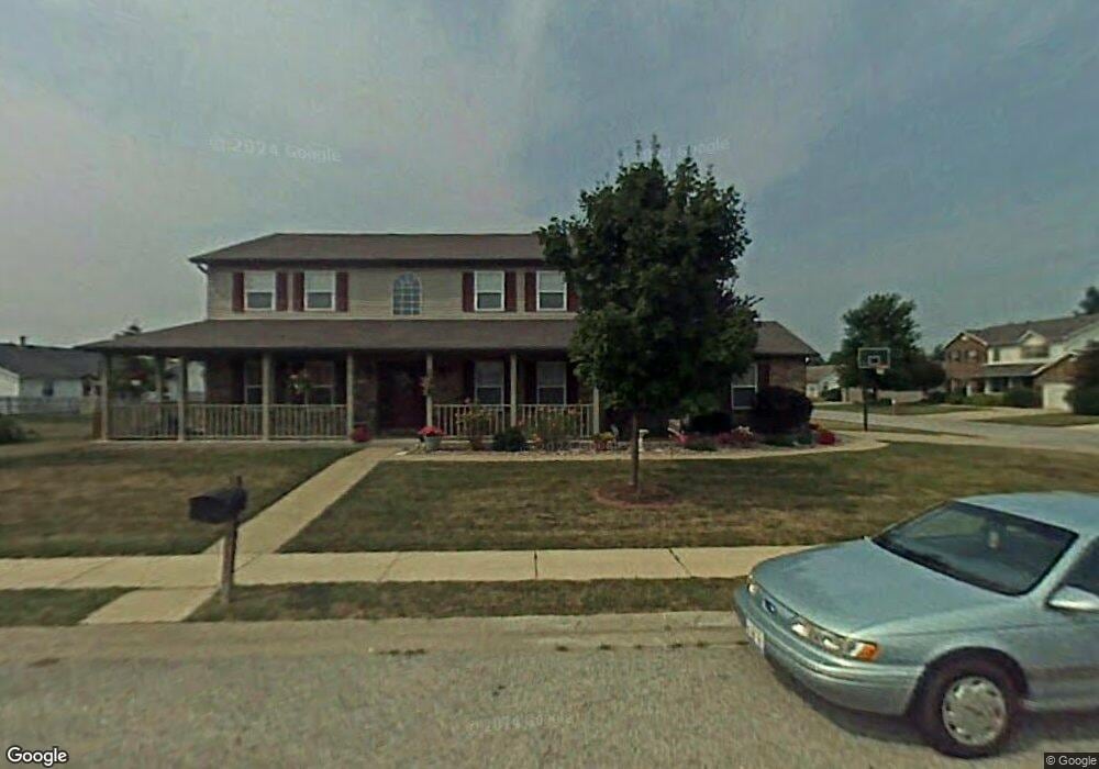
3865 Michael John Dr Swansea, IL 62226
Estimated Value: $289,651 - $361,000
Studio
--
Bath
1,280
Sq Ft
$254/Sq Ft
Est. Value
About This Home
This home is located at 3865 Michael John Dr, Swansea, IL 62226 and is currently estimated at $325,413, approximately $254 per square foot. 3865 Michael John Dr is a home located in St. Clair County with nearby schools including Wolf Branch Elementary School, Wolf Branch Middle School, and Elite Scholars STEAM Academy.
Ownership History
Date
Name
Owned For
Owner Type
Purchase Details
Closed on
Sep 24, 2004
Sold by
Carrier Curtis T and Carrier Christine M
Bought by
Eversman Kurt R and Eversman Julie L
Current Estimated Value
Home Financials for this Owner
Home Financials are based on the most recent Mortgage that was taken out on this home.
Original Mortgage
$180,000
Outstanding Balance
$89,593
Interest Rate
5.95%
Mortgage Type
Purchase Money Mortgage
Estimated Equity
$235,820
Create a Home Valuation Report for This Property
The Home Valuation Report is an in-depth analysis detailing your home's value as well as a comparison with similar homes in the area
Home Values in the Area
Average Home Value in this Area
Purchase History
| Date | Buyer | Sale Price | Title Company |
|---|---|---|---|
| Eversman Kurt R | $225,000 | Benedick Title Ins |
Source: Public Records
Mortgage History
| Date | Status | Borrower | Loan Amount |
|---|---|---|---|
| Open | Eversman Kurt R | $180,000 |
Source: Public Records
Tax History
| Year | Tax Paid | Tax Assessment Tax Assessment Total Assessment is a certain percentage of the fair market value that is determined by local assessors to be the total taxable value of land and additions on the property. | Land | Improvement |
|---|---|---|---|---|
| 2024 | $6,606 | $88,186 | $9,928 | $78,258 |
| 2023 | $6,144 | $81,710 | $9,791 | $71,919 |
| 2022 | $5,714 | $74,417 | $8,917 | $65,500 |
| 2021 | $5,567 | $71,363 | $8,551 | $62,812 |
| 2020 | $5,399 | $66,459 | $7,963 | $58,496 |
| 2019 | $5,370 | $67,876 | $8,126 | $59,750 |
| 2018 | $5,223 | $66,144 | $7,919 | $58,225 |
| 2017 | $5,080 | $64,383 | $7,708 | $56,675 |
| 2016 | $5,041 | $62,163 | $7,442 | $54,721 |
| 2014 | $5,055 | $69,708 | $13,708 | $56,000 |
| 2013 | $5,471 | $69,708 | $13,708 | $56,000 |
Source: Public Records
Map
Nearby Homes
- 532 Homestead Ave
- 802 Baron Dr
- 3906 Benington Dr
- 505 Thistle Ln
- 504 Crestwood Dr
- 147 Papillon Dr
- 3804 Tanbark Dr
- 41 Village Dr
- 3616 Moorgate Ct
- 1737 Old Park Ln
- 1853 Old Park Ln
- 3920 Red Bird Ln
- 3916 Red Bird Ln
- 1849 Old Park Ln
- 1745 Old Park Ln
- 3909 Red Bird Ln
- 1749 Old Park Ln
- 1837 Old Park Ln
- 1721 Old Park Ln
- 1733 Old Park Ln
- 3881 Michael John Dr
- 806 Kendra Ann Dr
- 810 Kendra Ann Dr
- 3866 Michael John Dr
- 3885 Michael John Dr
- 3878 Michael John Dr
- 3862 Michael John Dr
- 3882 Michael John Dr
- 3870 Michael John Dr
- 814 Kendra Ann Dr
- 3874 Michael John Dr
- 3858 Michael John Dr
- 3886 Michael John Dr
- 3889 Michael John Dr
- 818 Kendra Ann Dr
- 3855 Michael John Dr
- 3890 Michael John Dr
- 3854 Michael John Dr
- 613 Deerfield Dr
- 521 Big Bend Blvd
Your Personal Tour Guide
Ask me questions while you tour the home.