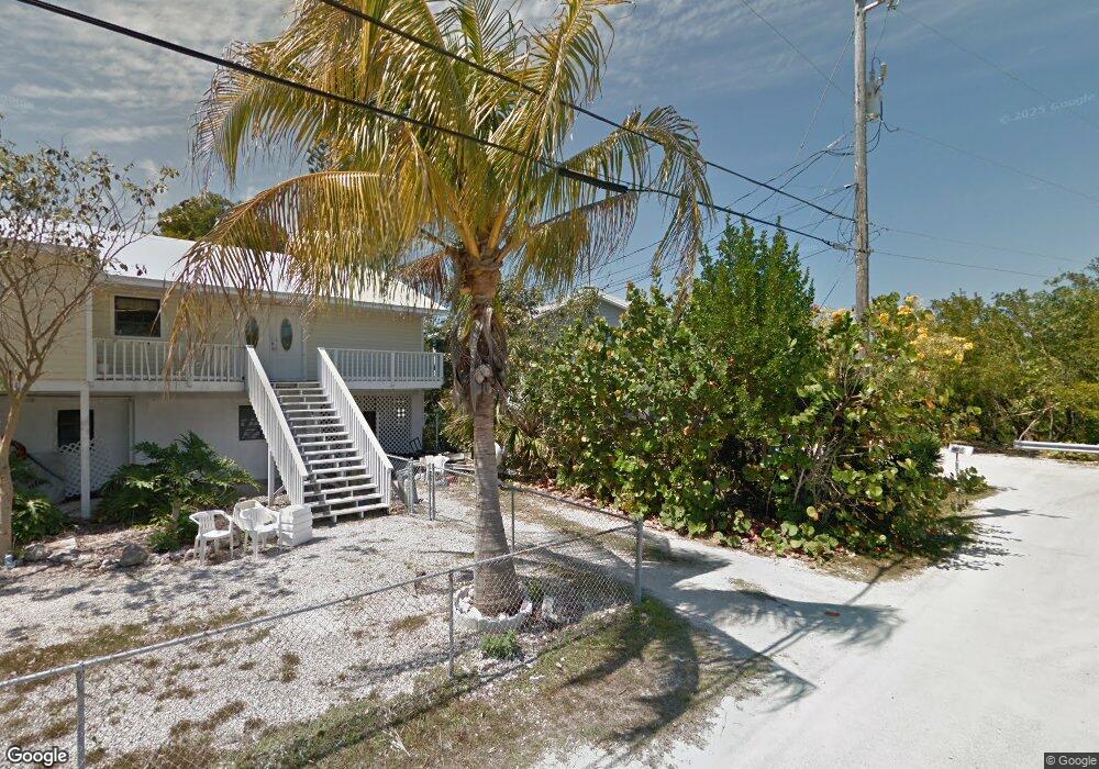
3866 Dyer Rd Big Pine Key, FL 33043
Estimated Value: $864,397 - $1,025,000
3
Beds
2
Baths
1,524
Sq Ft
$624/Sq Ft
Est. Value
About This Home
This home is located at 3866 Dyer Rd, Big Pine Key, FL 33043 and is currently estimated at $951,099, approximately $624 per square foot. 3866 Dyer Rd is a home located in Monroe County with nearby schools including Sugarloaf School, Marathon Middle High School, and Key West High School.
Ownership History
Date
Name
Owned For
Owner Type
Purchase Details
Closed on
Dec 22, 2006
Sold by
Sanders Dale D and Sanders Beth Ann
Bought by
Singleton Michael M and Singleton Bette Jo
Current Estimated Value
Home Financials for this Owner
Home Financials are based on the most recent Mortgage that was taken out on this home.
Original Mortgage
$436,000
Outstanding Balance
$250,918
Interest Rate
1%
Mortgage Type
Negative Amortization
Estimated Equity
$700,181
Purchase Details
Closed on
Dec 1, 2003
Sold by
The Nature Conservancy
Bought by
Sanders Dale Dean and Sanders Beth Ann
Home Financials for this Owner
Home Financials are based on the most recent Mortgage that was taken out on this home.
Original Mortgage
$339,200
Interest Rate
5.93%
Mortgage Type
Credit Line Revolving
Purchase Details
Closed on
Nov 19, 2003
Sold by
Pitts John D and Pitts Elizabeth A
Bought by
Sanders Dale Dean and Sanders Beth Ann
Home Financials for this Owner
Home Financials are based on the most recent Mortgage that was taken out on this home.
Original Mortgage
$339,200
Interest Rate
5.93%
Mortgage Type
Credit Line Revolving
Purchase Details
Closed on
Jan 19, 2000
Sold by
Rodriguez George and Rodriguez Margaret
Bought by
Pitts John D and Pitts Elizabeth A
Purchase Details
Closed on
Jul 29, 1996
Sold by
Rodriguez George and Rodriguez Margaret
Bought by
Pitts John D
Home Financials for this Owner
Home Financials are based on the most recent Mortgage that was taken out on this home.
Original Mortgage
$171,000
Interest Rate
8.36%
Mortgage Type
New Conventional
Purchase Details
Closed on
Nov 18, 1994
Sold by
Stjohn Jack V and Stjohn Constance W
Bought by
Rodriguez George and Rodriguez Margaret
Home Financials for this Owner
Home Financials are based on the most recent Mortgage that was taken out on this home.
Original Mortgage
$132,000
Interest Rate
8.92%
Purchase Details
Closed on
Nov 1, 1994
Bought by
Singleton Michael M and Singleton Bette-Jo
Home Financials for this Owner
Home Financials are based on the most recent Mortgage that was taken out on this home.
Original Mortgage
$132,000
Interest Rate
8.92%
Purchase Details
Closed on
Mar 1, 1989
Bought by
Singleton Michael M and Singleton Bette-Jo
Purchase Details
Closed on
Dec 1, 1980
Bought by
Singleton Michael M and Singleton Bette-Jo
Purchase Details
Closed on
Oct 1, 1979
Bought by
Singleton Michael M and Singleton Bette-Jo
Create a Home Valuation Report for This Property
The Home Valuation Report is an in-depth analysis detailing your home's value as well as a comparison with similar homes in the area
Home Values in the Area
Average Home Value in this Area
Purchase History
| Date | Buyer | Sale Price | Title Company |
|---|---|---|---|
| Singleton Michael M | $545,000 | Crest Title Company | |
| Sanders Dale Dean | -- | First American Title Ins Co | |
| Sanders Dale Dean | $424,000 | First American Title Ins Co | |
| Pitts John D | -- | -- | |
| Pitts John D | $180,000 | -- | |
| Rodriguez George | $165,000 | -- | |
| Singleton Michael M | $165,000 | -- | |
| Singleton Michael M | $30,000 | -- | |
| Singleton Michael M | $17,000 | -- | |
| Singleton Michael M | $11,500 | -- |
Source: Public Records
Mortgage History
| Date | Status | Borrower | Loan Amount |
|---|---|---|---|
| Open | Singleton Michael M | $436,000 | |
| Previous Owner | Sanders Dale Dean | $339,200 | |
| Previous Owner | Pitts John D | $171,000 | |
| Previous Owner | Rodriguez George | $132,000 | |
| Closed | Sanders Dale Dean | $42,400 |
Source: Public Records
Tax History
| Year | Tax Paid | Tax Assessment Tax Assessment Total Assessment is a certain percentage of the fair market value that is determined by local assessors to be the total taxable value of land and additions on the property. | Land | Improvement |
|---|---|---|---|---|
| 2025 | $3,328 | $382,131 | -- | -- |
| 2024 | $3,157 | $371,362 | -- | -- |
| 2023 | $3,157 | $360,546 | $0 | $0 |
| 2022 | $3,066 | $350,045 | $0 | $0 |
| 2021 | $3,139 | $339,850 | $0 | $0 |
| 2020 | $3,119 | $335,158 | $0 | $0 |
| 2019 | $2,918 | $312,611 | $0 | $0 |
| 2018 | $3,077 | $322,463 | $0 | $0 |
| 2017 | $2,986 | $315,831 | $0 | $0 |
| 2016 | $3,002 | $309,335 | $0 | $0 |
| 2015 | $3,092 | $307,185 | $0 | $0 |
| 2014 | $3,186 | $304,747 | $0 | $0 |
Source: Public Records
Map
Nearby Homes
- 3856 Donna Rd
- 3943 Venna Rd
- 3831 Sunset Dr
- 3759 Seagrape St
- 3742 Seagrape St
- 3836 No Name Rd
- 3962 No Name Rd
- 3635 Tradewinds St
- 3635 Trade Winds St
- 3686 Gulfstream St
- 3672 Fox St
- 3633 Blue Lagoon St
- 3746 Park Ave
- 3231 Pompano St
- 3127 Stewart Rd
- Vacant Lot Canal St
- 29051 Magnolia Ln
- 29160 Primrose Ln
- 29112 Poinsettia Ln
- 29182 Orchid Ln
Your Personal Tour Guide
Ask me questions while you tour the home.