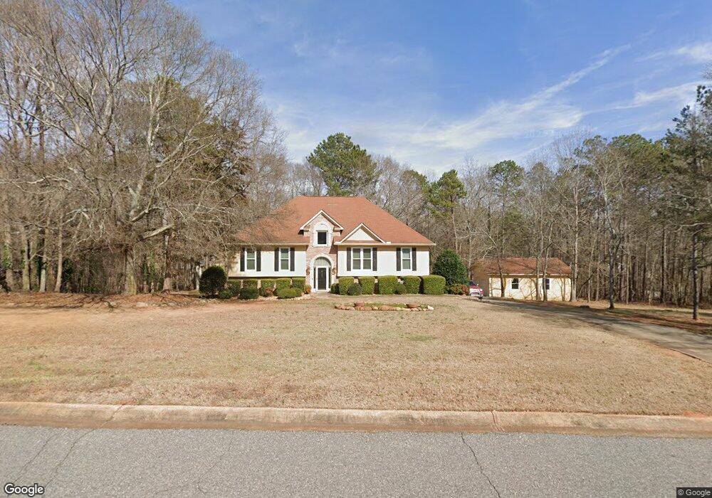
387 Kingston Rd Colbert, GA 30628
Estimated Value: $374,000 - $435,000
5
Beds
3
Baths
2,560
Sq Ft
$160/Sq Ft
Est. Value
About This Home
This home is located at 387 Kingston Rd, Colbert, GA 30628 and is currently estimated at $408,670, approximately $159 per square foot. 387 Kingston Rd is a home located in Madison County with nearby schools including Madison County High School.
Ownership History
Date
Name
Owned For
Owner Type
Purchase Details
Closed on
Sep 3, 2003
Sold by
Schmidt Micahel and Schmidt Joanne
Bought by
Brown Willie James and Brown Sharon W
Current Estimated Value
Purchase Details
Closed on
Feb 26, 2001
Sold by
Ankney James K
Bought by
Brown Willie J and Brown Sha
Purchase Details
Closed on
May 26, 1999
Sold by
Dubay Douglas R
Bought by
Ankney James K
Purchase Details
Closed on
Jan 30, 1996
Bought by
Dubay Douglas R
Create a Home Valuation Report for This Property
The Home Valuation Report is an in-depth analysis detailing your home's value as well as a comparison with similar homes in the area
Home Values in the Area
Average Home Value in this Area
Purchase History
| Date | Buyer | Sale Price | Title Company |
|---|---|---|---|
| Brown Willie James | $11,000 | -- | |
| Brown Willie J | $188,000 | -- | |
| Ankney James K | $174,900 | -- | |
| Dubay Douglas R | $146,500 | -- |
Source: Public Records
Tax History Compared to Growth
Tax History
| Year | Tax Paid | Tax Assessment Tax Assessment Total Assessment is a certain percentage of the fair market value that is determined by local assessors to be the total taxable value of land and additions on the property. | Land | Improvement |
|---|---|---|---|---|
| 2024 | $3,242 | $134,571 | $16,560 | $118,011 |
| 2023 | $2,599 | $127,855 | $16,560 | $111,295 |
| 2022 | $3,012 | $119,200 | $16,560 | $102,640 |
| 2021 | $2,718 | $99,051 | $16,560 | $82,491 |
| 2020 | $2,983 | $99,051 | $16,560 | $82,491 |
| 2019 | $2,763 | $90,861 | $16,560 | $74,301 |
| 2018 | $2,732 | $89,605 | $16,560 | $73,045 |
| 2017 | $2,504 | $86,956 | $16,560 | $70,396 |
| 2016 | $2,228 | $79,622 | $16,560 | $63,062 |
| 2015 | $2,082 | $74,494 | $11,431 | $63,062 |
| 2014 | $1,950 | $69,479 | $11,431 | $58,048 |
| 2013 | -- | $69,479 | $11,431 | $58,048 |
Source: Public Records
Map
Nearby Homes
- 00 Kingston Rd
- 270 Lola St
- 118 Kingston Rd
- 95 Lola St
- 0 Kingston Rd Unit 10531125
- 120 Harold's Way
- 0 Bluff Rd Unit 10591799
- 77 Sugar Maple Way Unit 44
- 45 Sugar Maple Way Unit 43
- 208 Redbud Trail Unit 48
- 14 Sourwood Trail Unit 53
- 0 Old Kincaid Rd Unit CL336310
- 0 Old Kincaid Rd Unit 10582354
- 180 S 4th St
- 0 2nd Ave
- 49 Kristin Ct
- 45 Southwinds Dr
- 0 Kincaid Cemetery Rd Unit 10626668
- 0 Kincaid Cemetery Rd Unit 7662961
- 0 Kincaid Cemetery Rd Unit CL341804
- 355 Kingston Rd
- 701 Kingston Rd
- 445 Kingston Rd
- 711 Kingston Rd
- 735 Kingston Rd
- 673 Kingston Rd
- 333 Kingston Rd
- 376 Kingston Rd
- 336 Kingston Rd
- 465 Kingston Rd
- 0 Kingston Cir Unit 7401088
- 647 Kingston Rd
- 440 Kingston Rd
- 420 Kingston Rd
- 797 Kingston Rd
- 464 Kingston Rd
- 299 Kingston Rd
- 1246 Kingston Cir
- 682 Kingston Rd
- 535 Kingston Rd