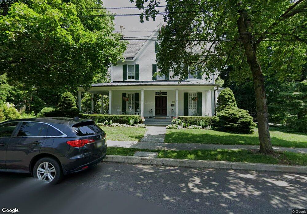
388 Maple Ave Doylestown, PA 18901
Estimated Value: $915,469 - $1,444,000
4
Beds
2
Baths
2,924
Sq Ft
$416/Sq Ft
Est. Value
About This Home
This home is located at 388 Maple Ave, Doylestown, PA 18901 and is currently estimated at $1,217,617, approximately $416 per square foot. 388 Maple Ave is a home located in Bucks County with nearby schools including Linden El School, Lenape Middle School, and Central Bucks High School-West.
Ownership History
Date
Name
Owned For
Owner Type
Purchase Details
Closed on
Jun 19, 1998
Sold by
Richard D Zaveta Jr Inc
Bought by
Dolan Spiro Paul David and Dolan Spiro Kathleen
Current Estimated Value
Home Financials for this Owner
Home Financials are based on the most recent Mortgage that was taken out on this home.
Original Mortgage
$227,000
Outstanding Balance
$45,571
Interest Rate
7.09%
Estimated Equity
$1,172,046
Purchase Details
Closed on
Feb 27, 1998
Sold by
Feeney William and Feeney Carol
Bought by
Richard D Zaveta Jr Inc
Home Financials for this Owner
Home Financials are based on the most recent Mortgage that was taken out on this home.
Original Mortgage
$356,250
Interest Rate
6.92%
Purchase Details
Closed on
Oct 12, 1994
Sold by
Finch Bernard L and Finch Patricia Ann
Bought by
Kevinbuilt Inc
Create a Home Valuation Report for This Property
The Home Valuation Report is an in-depth analysis detailing your home's value as well as a comparison with similar homes in the area
Home Values in the Area
Average Home Value in this Area
Purchase History
| Date | Buyer | Sale Price | Title Company |
|---|---|---|---|
| Dolan Spiro Paul David | -- | -- | |
| Richard D Zaveta Jr Inc | $475,000 | -- | |
| Kevinbuilt Inc | $210,000 | Stewart Title Guaranty Compa |
Source: Public Records
Mortgage History
| Date | Status | Borrower | Loan Amount |
|---|---|---|---|
| Open | Dolan Spiro Paul David | $227,000 | |
| Previous Owner | Richard D Zaveta Jr Inc | $356,250 |
Source: Public Records
Tax History
| Year | Tax Paid | Tax Assessment Tax Assessment Total Assessment is a certain percentage of the fair market value that is determined by local assessors to be the total taxable value of land and additions on the property. | Land | Improvement |
|---|---|---|---|---|
| 2025 | $7,220 | $40,080 | $12,800 | $27,280 |
| 2024 | $7,220 | $40,080 | $12,800 | $27,280 |
| 2023 | $6,879 | $40,080 | $12,800 | $27,280 |
| 2022 | $6,784 | $40,080 | $12,800 | $27,280 |
| 2021 | $6,709 | $40,080 | $12,800 | $27,280 |
| 2020 | $6,635 | $40,080 | $12,800 | $27,280 |
| 2019 | $6,562 | $40,080 | $12,800 | $27,280 |
| 2018 | $6,482 | $40,080 | $12,800 | $27,280 |
| 2017 | $6,414 | $40,080 | $12,800 | $27,280 |
| 2016 | $6,414 | $40,080 | $12,800 | $27,280 |
| 2015 | -- | $40,080 | $12,800 | $27,280 |
| 2014 | -- | $40,080 | $12,800 | $27,280 |
Source: Public Records
Map
Nearby Homes
- 9 Maple Ln
- 146 E Court St
- 150 Selner Ln
- 5 Belmont Square
- 169 N Main St
- 110 E Ashland St
- 69 E Oakland Ave
- 102 Clear Springs Ct
- 607 S Chubb Dr
- 236 Green St
- 34 Houk Rd
- 190 Decatur St
- 45 Springs Dr
- 215 N Franklin St
- 6 Edison Ln Unit 1
- 195 Lafayette St
- 807 N Broad St
- 1 Steeplechase Dr
- 000 Cherry Ln
- 117 Cottonwood Ct
Your Personal Tour Guide
Ask me questions while you tour the home.