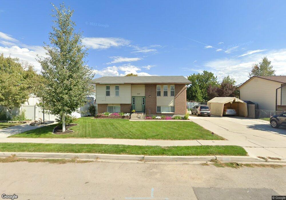
388 N 520 W American Fork, UT 84003
Estimated Value: $460,000 - $495,000
4
Beds
2
Baths
1,852
Sq Ft
$257/Sq Ft
Est. Value
About This Home
This home is located at 388 N 520 W, American Fork, UT 84003 and is currently estimated at $475,697, approximately $256 per square foot. 388 N 520 W is a home located in Utah County with nearby schools including Shelley Elementary School, American Fork Junior High School, and American Fork High School.
Ownership History
Date
Name
Owned For
Owner Type
Purchase Details
Closed on
Aug 2, 2024
Sold by
Jones Benjamin M and Jones Courtney M
Bought by
Egbert Timothy D and Egbert Susie
Current Estimated Value
Purchase Details
Closed on
Apr 1, 2021
Sold by
Jones Benjamin and Jones Courtney
Bought by
Egbert Timothy D and Egbert Susie
Home Financials for this Owner
Home Financials are based on the most recent Mortgage that was taken out on this home.
Original Mortgage
$282,000
Interest Rate
2.8%
Mortgage Type
New Conventional
Purchase Details
Closed on
Oct 5, 2016
Sold by
Taylor Brookanne and Taylor Brent
Bought by
Jones Benjamin M and Jones Courtney M
Home Financials for this Owner
Home Financials are based on the most recent Mortgage that was taken out on this home.
Original Mortgage
$220,924
Interest Rate
3.25%
Mortgage Type
FHA
Purchase Details
Closed on
Jul 14, 2014
Sold by
Hansen Steven James and Hansen Breanne
Bought by
Taylor Brookanne and Taylor Brent
Home Financials for this Owner
Home Financials are based on the most recent Mortgage that was taken out on this home.
Original Mortgage
$188,522
Interest Rate
3.87%
Mortgage Type
FHA
Purchase Details
Closed on
Sep 2, 2011
Sold by
The Secretary Of Housing & Urban Develop
Bought by
Hansen Steven James and Hansen Breanne
Home Financials for this Owner
Home Financials are based on the most recent Mortgage that was taken out on this home.
Original Mortgage
$5,000
Interest Rate
4.48%
Mortgage Type
Stand Alone Second
Purchase Details
Closed on
Apr 19, 2011
Sold by
Wells Fargo Bank Na
Bought by
Secretary Of Housing & Urban Development
Purchase Details
Closed on
Apr 5, 2011
Sold by
Webb Charles J and Webb Donalee
Bought by
Wells Fargo Bank Na
Create a Home Valuation Report for This Property
The Home Valuation Report is an in-depth analysis detailing your home's value as well as a comparison with similar homes in the area
Home Values in the Area
Average Home Value in this Area
Purchase History
| Date | Buyer | Sale Price | Title Company |
|---|---|---|---|
| Egbert Timothy D | -- | Inwest Title | |
| Egbert Timothy D | -- | Vanguard Title Ins Agency | |
| Jones Benjamin M | -- | First American Title Ins Age | |
| Taylor Brookanne | -- | Greenbrier Title Ins Agency | |
| Hansen Steven James | -- | Monument Title Insurance Inc | |
| Secretary Of Housing & Urban Development | -- | Inwest Title Ogden | |
| Wells Fargo Bank Na | $238,080 | Etitle Insurance Agency |
Source: Public Records
Mortgage History
| Date | Status | Borrower | Loan Amount |
|---|---|---|---|
| Previous Owner | Egbert Timothy D | $282,000 | |
| Previous Owner | Jones Benjamin M | $220,924 | |
| Previous Owner | Taylor Brookanne | $188,522 | |
| Previous Owner | Hansen Steven James | $5,000 | |
| Previous Owner | Hansen Steven James | $113,511 |
Source: Public Records
Tax History Compared to Growth
Tax History
| Year | Tax Paid | Tax Assessment Tax Assessment Total Assessment is a certain percentage of the fair market value that is determined by local assessors to be the total taxable value of land and additions on the property. | Land | Improvement |
|---|---|---|---|---|
| 2025 | $1,935 | $237,160 | $184,900 | $246,300 |
| 2024 | $1,935 | $214,995 | $0 | $0 |
| 2023 | $1,812 | $213,455 | $0 | $0 |
| 2022 | $1,929 | $224,290 | $0 | $0 |
| 2021 | $1,650 | $299,600 | $132,700 | $166,900 |
| 2020 | $1,542 | $271,600 | $118,500 | $153,100 |
| 2019 | $1,395 | $254,100 | $101,600 | $152,500 |
| 2018 | $1,286 | $224,000 | $91,400 | $132,600 |
| 2017 | $1,237 | $116,270 | $0 | $0 |
| 2016 | -- | $103,840 | $0 | $0 |
| 2015 | $1,145 | $94,930 | $0 | $0 |
| 2014 | $1,082 | $88,495 | $0 | $0 |
Source: Public Records
Map
Nearby Homes
- 356 N 480 W
- 399 W Pacific Dr
- 370 W Pacific Dr Unit 1
- 641 N 420 W
- 540 N 300 W
- 777 W State Rd
- 120 N 350 W Unit 127
- 120 N 350 W Unit 133
- 120 N 350 W Unit 130
- 365 N 100 W
- 217 W Main St
- 962 N 780 St W Unit 508
- 974 N 780 St W Unit 509
- 916 N 780 St W Unit 501
- 55 Roosevelt Ave
- 621 N 100 W
- 129 W Pacific Dr
- 105 N 100 W
- 602 W 860 N
- 82 S Lincoln Ave