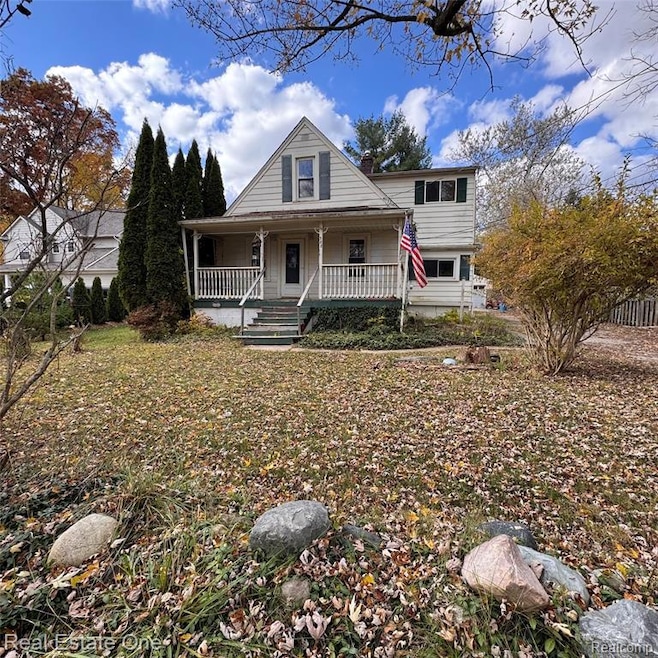
388 Norland St Lake Orion, MI 48362
Estimated payment $1,400/month
Highlights
- Colonial Architecture
- No HOA
- 2 Car Detached Garage
- Blanche Sims Elementary School Rated A-
- Covered Patio or Porch
- 3-minute walk to Atwater Park
About This Home
Discover the potential in a prime Downtown Lake Orion location! This 4-bedroom, 2-bath home sits on a quiet dead-end street walking distance to downtown shops, restaurants, and parks. Original hardwood floors run throughout, adding charm and character. The home needs updates but offers solid bones and endless opportunity to customize and gain equity. Enjoy a large, fully fenced yard and a detached 2-car garage—perfect for storage or a workshop once updated. A rare find combining walkability, privacy, and space—don’t miss your chance to make this home your own!
Home Details
Home Type
- Single Family
Est. Annual Taxes
Year Built
- Built in 1920
Lot Details
- 0.26 Acre Lot
- Lot Dimensions are 141x80
- Dirt Road
Parking
- 2 Car Detached Garage
Home Design
- Colonial Architecture
- Block Foundation
Interior Spaces
- 1,390 Sq Ft Home
- 2-Story Property
- Unfinished Basement
Bedrooms and Bathrooms
- 4 Bedrooms
- 2 Full Bathrooms
Utilities
- Forced Air Heating System
- Heating System Uses Natural Gas
Additional Features
- Covered Patio or Porch
- Ground Level
Community Details
- No Home Owners Association
- O S Axfords Add Subdivision
Listing and Financial Details
- Assessor Parcel Number 0912153040
Map
Home Values in the Area
Average Home Value in this Area
Tax History
| Year | Tax Paid | Tax Assessment Tax Assessment Total Assessment is a certain percentage of the fair market value that is determined by local assessors to be the total taxable value of land and additions on the property. | Land | Improvement |
|---|---|---|---|---|
| 2024 | $2,325 | $114,230 | $0 | $0 |
| 2023 | $2,220 | $103,970 | $0 | $0 |
| 2022 | $2,581 | $93,520 | $0 | $0 |
| 2021 | $2,469 | $88,040 | $0 | $0 |
| 2020 | $2,038 | $82,070 | $0 | $0 |
| 2019 | $1,654 | $74,910 | $0 | $0 |
| 2018 | $2,343 | $72,730 | $0 | $0 |
| 2017 | $2,249 | $72,730 | $0 | $0 |
| 2016 | $2,237 | $67,390 | $0 | $0 |
| 2015 | -- | $62,380 | $0 | $0 |
| 2014 | -- | $56,140 | $0 | $0 |
| 2011 | -- | $51,980 | $0 | $0 |
Property History
| Date | Event | Price | List to Sale | Price per Sq Ft |
|---|---|---|---|---|
| 11/06/2025 11/06/25 | Pending | -- | -- | -- |
| 10/30/2025 10/30/25 | For Sale | $220,000 | -- | $158 / Sq Ft |
Purchase History
| Date | Type | Sale Price | Title Company |
|---|---|---|---|
| Sheriffs Deed | $134,904 | None Available | |
| Warranty Deed | $165,000 | The Title Company Of Mi Inc |
Mortgage History
| Date | Status | Loan Amount | Loan Type |
|---|---|---|---|
| Previous Owner | $33,000 | Stand Alone Second | |
| Previous Owner | $132,000 | Purchase Money Mortgage |
Source: Realcomp
MLS Number: 20251050031
APN: 09-12-153-040
Disclaimer: Certain information contained herein is derived from information provided by parties other than Homes.com. All information provided is deemed reliable, but is not guaranteed to be accurate and should be independently verified.
![]() IDX provided courtesy of Realcomp II Ltd. via Ten-X and MLS
IDX provided courtesy of Realcomp II Ltd. via Ten-X and MLS
Copyright 2025 Realcomp II Ltd. Shareholders
IDX information is provided exclusively for consumers' personal, noncommercial use and may not be used for any purpose other than to identify prospective properties consumers may be interested in purchasing. The accuracy of all information, regardless of source, is not guaranteed or warranted. All information should be independently verified.
Listing Information presented by local MLS brokerage: Ten-X, local REALTOR®- Arlene Richardson - (888)-952-6393
- 332 Newton Dr
- 400 E Flint St
- 418 Converse Ct
- 00 Heights Rd
- 328 S Broadway St
- 921 River Valley Dr
- 769 Markdale St
- 1160 Miller Rd
- 325 N Broadway St
- 229 W Flint St
- 0000 Garden Dr
- 285 Franklin Wright Blvd
- 0000 S Lapeer Rd
- 325 W Flint St
- 1334 de Goff Ct
- 1146 S Long Lake Blvd
- 0 Susan Marie St
- 1455 Orion Rd
- 126 N North Shore Dr
- 122 E Clarkston Rd
