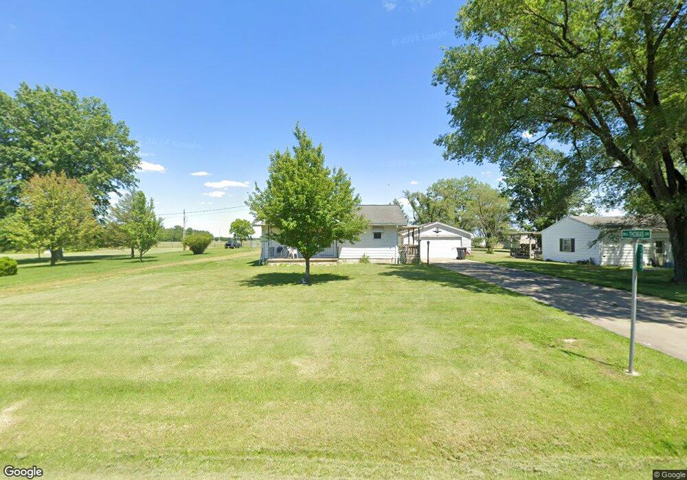
3880 Sand Creek Rd Decatur, IL 62521
Estimated Value: $124,000 - $140,000
--
Bed
--
Bath
952
Sq Ft
$140/Sq Ft
Est. Value
About This Home
This home is located at 3880 Sand Creek Rd, Decatur, IL 62521 and is currently estimated at $133,135, approximately $139 per square foot. 3880 Sand Creek Rd is a home located in Macon County with nearby schools including McGaughey Elementary School, Mt. Zion Elementary School, and Mt. Zion Intermediate School.
Ownership History
Date
Name
Owned For
Owner Type
Purchase Details
Closed on
May 10, 2023
Sold by
Thomas Billy G
Bought by
Smith Thuva and Gilman Dayna
Current Estimated Value
Home Financials for this Owner
Home Financials are based on the most recent Mortgage that was taken out on this home.
Original Mortgage
$76,000
Outstanding Balance
$68,242
Interest Rate
6.13%
Mortgage Type
New Conventional
Estimated Equity
$64,893
Create a Home Valuation Report for This Property
The Home Valuation Report is an in-depth analysis detailing your home's value as well as a comparison with similar homes in the area
Home Values in the Area
Average Home Value in this Area
Purchase History
| Date | Buyer | Sale Price | Title Company |
|---|---|---|---|
| Smith Thuva | $80,000 | None Listed On Document |
Source: Public Records
Mortgage History
| Date | Status | Borrower | Loan Amount |
|---|---|---|---|
| Open | Smith Thuva | $76,000 |
Source: Public Records
Tax History Compared to Growth
Tax History
| Year | Tax Paid | Tax Assessment Tax Assessment Total Assessment is a certain percentage of the fair market value that is determined by local assessors to be the total taxable value of land and additions on the property. | Land | Improvement |
|---|---|---|---|---|
| 2024 | $2,827 | $42,274 | $4,700 | $37,574 |
| 2023 | $2,645 | $37,951 | $4,700 | $33,251 |
| 2022 | $2,552 | $36,206 | $4,484 | $31,722 |
| 2021 | $1,656 | $34,444 | $4,266 | $30,178 |
| 2020 | $564 | $32,648 | $4,044 | $28,604 |
| 2019 | $564 | $32,648 | $4,044 | $28,604 |
| 2018 | $1,452 | $31,404 | $3,890 | $27,514 |
| 2017 | $559 | $31,112 | $3,854 | $27,258 |
| 2016 | $563 | $31,047 | $3,846 | $27,201 |
| 2015 | $552 | $30,143 | $3,734 | $26,409 |
| 2014 | $529 | $29,845 | $3,697 | $26,148 |
| 2013 | $538 | $29,845 | $3,697 | $26,148 |
Source: Public Records
Map
Nearby Homes
- 3137 Southland Rd
- 435 Dawson Rd
- 3020 S Laura St
- 4115 Meadow Park Dr
- 2330 S Shores Dr
- 2605 S Forrest Green Dr
- 0 E Danceland Rd
- 2626 S Forrest Green Dr
- 2628 S Forrest Green Dr
- 98 Ridgeway Dr
- 102 Phillips Dr
- 2125 Reserve Way
- 43 Ridgedale Dr
- 65 S Shores Dr
- 20 Ridge Dr
- 19 Peggy Ann Dr
- 405 Hackberry Dr
- 4090 S Lake Ct
- 0 S Shores Dr
- 411 Woodhill Dr
- 3930 Sandcreek Rd
- 3960 Sand Creek Rd
- 3855 Sand Creek Rd
- 3964 Sand Creek Rd
- 3838 Sand Creek Rd
- 3965 Sand Creek Rd
- 3965 Sand Creek Rd
- 3990 Sand Creek Rd
- 4010 Sand Creek Rd
- 4010 Sand Creek Rd
- 3820 Sandcreek Rd
- 3770 Sand Creek Rd
- 3763 Sand Creek Rd
- 3750 Sandcreek Rd
- 4090 Sand Creek Rd
- 3738 Sand Creek Rd
- 3738 Sand Creek Rd
- 3725 Sand Creek Rd
- 3718 Sand Creek Rd
- 3718 Sand Creek Rd