Estimated Value: $361,000 - $391,000
3
Beds
2
Baths
1,315
Sq Ft
$286/Sq Ft
Est. Value
About This Home
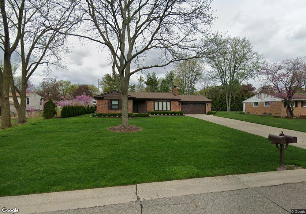
This home is located at 3885 Ruthland Dr, Troy, MI 48084 and is currently estimated at $375,560, approximately $285 per square foot. 3885 Ruthland Dr is a home located in Oakland County with nearby schools including Leonard Elementary School, Smith Middle School, and Troy High School.
Ownership History
Date
Name
Owned For
Owner Type
Purchase Details
Closed on
Feb 13, 2018
Sold by
Harper Mark A and Harper Kathryn A
Bought by
Harper Mark A and Harper Kathryn E
Current Estimated Value
Purchase Details
Closed on
May 24, 2013
Sold by
Harper Mark A and Rea Julie L
Bought by
Harper Mark A
Home Financials for this Owner
Home Financials are based on the most recent Mortgage that was taken out on this home.
Original Mortgage
$188,650
Outstanding Balance
$132,835
Interest Rate
3.34%
Mortgage Type
New Conventional
Estimated Equity
$242,725
Purchase Details
Closed on
Sep 26, 2006
Sold by
Kohler Robert M and Kohler Julie A
Bought by
Harper Mark A and Harper Julie R
Home Financials for this Owner
Home Financials are based on the most recent Mortgage that was taken out on this home.
Original Mortgage
$206,625
Interest Rate
6.49%
Mortgage Type
Purchase Money Mortgage
Create a Home Valuation Report for This Property
The Home Valuation Report is an in-depth analysis detailing your home's value as well as a comparison with similar homes in the area
Home Values in the Area
Average Home Value in this Area
Purchase History
| Date | Buyer | Sale Price | Title Company |
|---|---|---|---|
| Harper Mark A | -- | None Available | |
| Harper Mark A | -- | Title Source Inc | |
| Harper Mark A | $217,500 | Philip R Seaver Title Co Inc |
Source: Public Records
Mortgage History
| Date | Status | Borrower | Loan Amount |
|---|---|---|---|
| Open | Harper Mark A | $188,650 | |
| Closed | Harper Mark A | $206,625 |
Source: Public Records
Tax History Compared to Growth
Tax History
| Year | Tax Paid | Tax Assessment Tax Assessment Total Assessment is a certain percentage of the fair market value that is determined by local assessors to be the total taxable value of land and additions on the property. | Land | Improvement |
|---|---|---|---|---|
| 2022 | $3,152 | $133,270 | $0 | $0 |
| 2015 | $3,292 | $102,150 | $0 | $0 |
| 2014 | -- | $94,370 | $0 | $0 |
| 2011 | -- | $92,150 | $0 | $0 |
Source: Public Records
Map
Nearby Homes
- 133 Kirk Lane Dr
- 417 Carter Dr
- 3711 Old Creek Rd Unit 72
- 3990 Old Creek Rd
- 138 Evaline Dr
- 66 S Trail Ct
- 67 S Trail Ct
- 53 S Trail Ct
- 39 S Trail Ct
- 3598 Finch Dr
- 89 MacLynn Dr
- 3786 Mesa Dr Unit 13
- 4222 Tallman Dr Unit 1
- 112 Streamview Dr
- 4335 Cypress Dr
- 580 Colebrook Dr
- 3443 Ellenboro Dr
- Lot A Tallman Dr
- 3122 Frankton Ave
- 3287 Kilmer Dr
- 3907 Ruthland Dr
- 244 Scottsdale Dr
- 3892 Elizabeth Dr
- 3876 Elizabeth Dr
- 3908 Elizabeth Dr
- 3884 Ruthland Dr
- 3929 Ruthland Dr
- 3862 Ruthland Dr
- 3906 Ruthland Dr
- 3924 Elizabeth Dr Unit Bldg-Unit
- 3928 Ruthland Dr
- 243 Scottsdale Dr
- 3951 Ruthland Dr
- 253 Scottsdale Dr
- 3889 Elizabeth Dr
- 3944 Elizabeth Dr
- 3875 Elizabeth Dr
- 265 Scottsdale Dr
- 211 Scottsdale Dr
- 3905 Elizabeth Dr