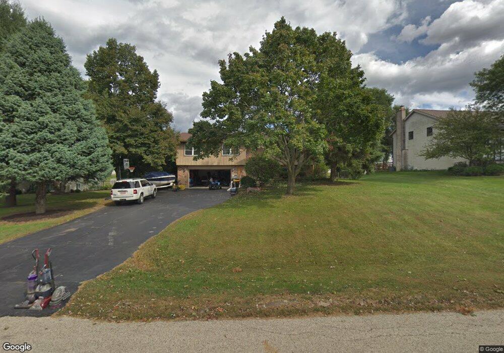
389 Towne St Gilberts, IL 60136
Estimated Value: $328,842 - $431,000
3
Beds
3
Baths
2,106
Sq Ft
$191/Sq Ft
Est. Value
About This Home
This home is located at 389 Towne St, Gilberts, IL 60136 and is currently estimated at $402,461, approximately $191 per square foot. 389 Towne St is a home located in Kane County with nearby schools including Gilberts Elementary School, Dundee Middle School, and Hampshire High School.
Ownership History
Date
Name
Owned For
Owner Type
Purchase Details
Closed on
Aug 25, 2004
Sold by
Bouslog Philip R and Bouslog Geraldine L
Bought by
Muskat Lee and Muskat Josephine
Current Estimated Value
Home Financials for this Owner
Home Financials are based on the most recent Mortgage that was taken out on this home.
Original Mortgage
$195,500
Outstanding Balance
$95,959
Interest Rate
6.17%
Mortgage Type
Purchase Money Mortgage
Estimated Equity
$306,502
Create a Home Valuation Report for This Property
The Home Valuation Report is an in-depth analysis detailing your home's value as well as a comparison with similar homes in the area
Home Values in the Area
Average Home Value in this Area
Purchase History
| Date | Buyer | Sale Price | Title Company |
|---|---|---|---|
| Muskat Lee | $283,500 | Multiple |
Source: Public Records
Mortgage History
| Date | Status | Borrower | Loan Amount |
|---|---|---|---|
| Open | Muskat Lee | $195,500 |
Source: Public Records
Tax History
| Year | Tax Paid | Tax Assessment Tax Assessment Total Assessment is a certain percentage of the fair market value that is determined by local assessors to be the total taxable value of land and additions on the property. | Land | Improvement |
|---|---|---|---|---|
| 2024 | $6,513 | $105,097 | $32,207 | $72,890 |
| 2023 | $6,132 | $94,563 | $28,979 | $65,584 |
| 2022 | $6,550 | $92,867 | $28,979 | $63,888 |
| 2021 | $6,322 | $87,685 | $27,362 | $60,323 |
| 2020 | $6,194 | $85,714 | $26,747 | $58,967 |
| 2019 | $5,994 | $81,369 | $25,391 | $55,978 |
| 2018 | $6,477 | $84,253 | $28,842 | $55,411 |
| 2017 | $6,172 | $78,814 | $26,980 | $51,834 |
| 2016 | $5,844 | $76,311 | $26,123 | $50,188 |
| 2015 | -- | $71,506 | $24,478 | $47,028 |
| 2014 | -- | $69,531 | $23,802 | $45,729 |
| 2013 | -- | $71,660 | $24,531 | $47,129 |
Source: Public Records
Map
Nearby Homes
- 568 Pamela St
- 0 Tyrrell Rd
- 747 Jamestowne Ct
- 523 Town Center Blvd
- 616 Joy Ln Unit 15
- 325 Settlers Place
- 337 Settlers Place
- 333 Settlers Place
- 329 Settlers Place
- 140 Harvest Ln
- 603 Arlington Pkwy
- 247 Settlers Place
- 243 Settlers Place
- 335 Settlers Place
- 562 Gunnison Ct Unit 6305
- 247 Evergreen Cir Unit 6152
- 198 Timber Trails Blvd Unit 6442
- 110 Easton Dr
- 340 Town Center Blvd
- 82 Brentwood Dr Unit 8
Your Personal Tour Guide
Ask me questions while you tour the home.