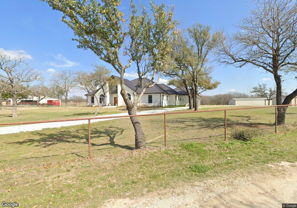
3891 Tin Top Rd Weatherford, TX 76087
Estimated Value: $762,000 - $2,076,000
5
Beds
3
Baths
4,442
Sq Ft
$265/Sq Ft
Est. Value
About This Home
This home is located at 3891 Tin Top Rd, Weatherford, TX 76087 and is currently estimated at $1,178,320, approximately $265 per square foot. 3891 Tin Top Rd is a home located in Parker County with nearby schools including Curtis Elementary School, Hall Middle School, and Weatherford High School.
Ownership History
Date
Name
Owned For
Owner Type
Purchase Details
Closed on
Oct 18, 2022
Sold by
Zaugg Daniel Neil
Bought by
Wheeling Everett Thomas and Wheeling Elizabeth Marie
Current Estimated Value
Home Financials for this Owner
Home Financials are based on the most recent Mortgage that was taken out on this home.
Original Mortgage
$600,000
Outstanding Balance
$338,955
Interest Rate
5.89%
Mortgage Type
Seller Take Back
Estimated Equity
$839,365
Purchase Details
Closed on
Aug 14, 2015
Sold by
Zaugg Daniel Neil
Bought by
Zaugg Daniel Neil
Purchase Details
Closed on
Jan 1, 1901
Bought by
Zaugg Daniel N
Create a Home Valuation Report for This Property
The Home Valuation Report is an in-depth analysis detailing your home's value as well as a comparison with similar homes in the area
Home Values in the Area
Average Home Value in this Area
Purchase History
| Date | Buyer | Sale Price | Title Company |
|---|---|---|---|
| Wheeling Everett Thomas | -- | Trinity Title | |
| Zaugg Daniel Neil | -- | Attorney | |
| Zaugg Daniel N | -- | -- |
Source: Public Records
Mortgage History
| Date | Status | Borrower | Loan Amount |
|---|---|---|---|
| Open | Wheeling Everett Thomas | $600,000 |
Source: Public Records
Tax History Compared to Growth
Tax History
| Year | Tax Paid | Tax Assessment Tax Assessment Total Assessment is a certain percentage of the fair market value that is determined by local assessors to be the total taxable value of land and additions on the property. | Land | Improvement |
|---|---|---|---|---|
| 2025 | $14,482 | $719,115 | $76,310 | $642,805 |
| 2024 | $14,482 | $892,840 | $86,190 | $806,650 |
| 2023 | $14,482 | $571,100 | $0 | $0 |
| 2022 | $9,655 | $519,190 | $66,040 | $453,150 |
| 2021 | $9,835 | $519,190 | $66,040 | $453,150 |
| 2020 | $8,984 | $461,550 | $60,600 | $400,950 |
| 2019 | $8,704 | $461,550 | $60,600 | $400,950 |
| 2018 | $7,982 | $366,960 | $41,370 | $325,590 |
| 2017 | $8,145 | $366,960 | $41,370 | $325,590 |
| 2016 | $7,866 | $354,370 | $33,410 | $320,960 |
| 2015 | $4,229 | $354,370 | $33,410 | $320,960 |
| 2014 | $4,352 | $330,440 | $33,410 | $297,030 |
Source: Public Records
Map
Nearby Homes
- 3952 Tin Top Rd
- 1020 Bluebonnet Ridge
- 1019 Bluebonnet Ridge
- 800 Purselly Ct
- 2001 Pinetree Post
- 1001 Bluebonnet Ridge
- TBD Shanes Ln
- 109 N Silver Saddle Trail
- 108 N Silver Saddle Trail
- 2013 Star Brooke Ln
- XXX Tin Top Rd
- 145 Tobiano Trace
- 133 Tobiano Trace
- 650 Spring Creek Pkwy
- 3007 Wyatts Way
- 1021 Annabelles Ave
- 1009 Annabelles Ave
- 1049 Annabelles Ave
- 1053 Annabelles Ave
- 1064 Annabelles Ave
- 3904 Tin Top Rd
- 3877 Tin Top Rd
- 3955 Tin Top Rd
- 3952 Tin Top Rd
- 1048 Bluebonnet Ridge
- 1040 Bluebonnet Ridge
- 1052 Bluebonnet Ridge
- 3830 Tin Top Rd
- 1036 Bluebonnet Ridge
- 1056 Bluebonnet Ridge
- 1032 Bluebonnet Ridge
- 3818 Tin Top Rd
- 1060 Bluebonnet Ridge
- 4043 Tin Top Rd
- Lot 28 Block 3
- Lot 5 Bluebonnet Ridge
- 1028 Bluebonnet Ridge
- 2016 Pinetree Post
- 1027 Bluebonnet Ridge
- Lot 7 Bluebonnet Ridge