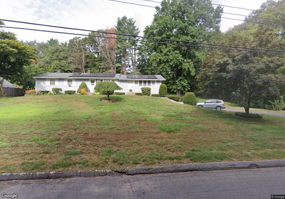
39 Alpine Rd Burlington, CT 06013
Estimated Value: $397,239 - $464,000
3
Beds
3
Baths
1,632
Sq Ft
$260/Sq Ft
Est. Value
About This Home
This home is located at 39 Alpine Rd, Burlington, CT 06013 and is currently estimated at $424,560, approximately $260 per square foot. 39 Alpine Rd is a home located in Hartford County with nearby schools including Lake Garda Elementary School, Har-Bur Middle School, and Lewis S. Mills High School.
Ownership History
Date
Name
Owned For
Owner Type
Purchase Details
Closed on
Mar 25, 2004
Sold by
Nardi William N and Nardi Sandra E
Bought by
Molusis Laura
Current Estimated Value
Purchase Details
Closed on
Jul 5, 2000
Sold by
Desimone Carol
Bought by
Nardi William M and Nardi Sandra E
Purchase Details
Closed on
Oct 31, 1994
Sold by
Verhagen Frank A and Verhagen Judith O
Bought by
Bruno John J and Bruno Carol
Create a Home Valuation Report for This Property
The Home Valuation Report is an in-depth analysis detailing your home's value as well as a comparison with similar homes in the area
Home Values in the Area
Average Home Value in this Area
Purchase History
| Date | Buyer | Sale Price | Title Company |
|---|---|---|---|
| Molusis Laura | $238,000 | -- | |
| Nardi William M | $165,000 | -- | |
| Bruno John J | $139,000 | -- | |
| Molusis Laura | $238,000 | -- | |
| Nardi William M | $165,000 | -- | |
| Bruno John J | $139,000 | -- |
Source: Public Records
Mortgage History
| Date | Status | Borrower | Loan Amount |
|---|---|---|---|
| Open | Bruno John J | $211,300 | |
| Closed | Bruno John J | $229,000 |
Source: Public Records
Tax History
| Year | Tax Paid | Tax Assessment Tax Assessment Total Assessment is a certain percentage of the fair market value that is determined by local assessors to be the total taxable value of land and additions on the property. | Land | Improvement |
|---|---|---|---|---|
| 2025 | $5,616 | $211,120 | $52,710 | $158,410 |
| 2024 | $5,468 | $211,120 | $52,710 | $158,410 |
| 2023 | $4,900 | $152,180 | $58,660 | $93,520 |
| 2022 | $4,976 | $152,180 | $58,660 | $93,520 |
| 2021 | $5,083 | $152,180 | $58,660 | $93,520 |
| 2020 | $5,068 | $152,180 | $58,660 | $93,520 |
| 2019 | $5,022 | $152,180 | $58,660 | $93,520 |
| 2018 | $4,800 | $147,700 | $58,660 | $89,040 |
| 2017 | $4,726 | $147,700 | $58,660 | $89,040 |
| 2016 | $4,687 | $148,330 | $58,660 | $89,670 |
| 2015 | $4,613 | $148,330 | $58,660 | $89,670 |
| 2014 | $4,428 | $148,330 | $58,660 | $89,670 |
Source: Public Records
Map
Nearby Homes
- 8 Gateshead Way
- 26 George Washington Turnpike
- 8 Old Field Rd
- 52 Wood Creek Rd
- 12 Woodside St
- 61 Litchfield Rd
- 50 Woodhaven Dr
- 8919 Taine Mountain Rd
- 10 Stone Ridge Crossing
- 42 Keene Place
- 55 Depot Place
- 39 Jerome Ave
- 24 Green Woods Ln
- 19 Village View Ln
- 23 Keyes St
- 60 Wildcat Rd
- 2 Ventres Way
- 32 Canterbury Ln
- 361D George Washington Turnpike
- Map Block # 1-04-8 ( George Washington Turnpike
Your Personal Tour Guide
Ask me questions while you tour the home.