
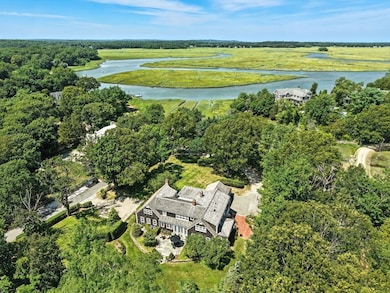
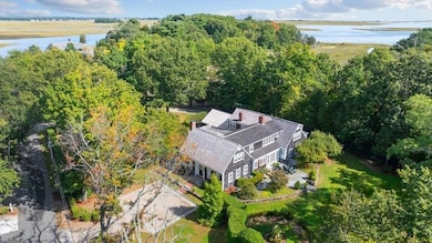
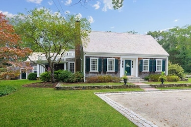
39 Bay Pond Rd Duxbury, MA 02332
Estimated payment $28,296/month
Highlights
- Marina
- Golf Course Community
- Custom Closet System
- Alden School Rated A-
- Waterfront
- Cape Cod Architecture
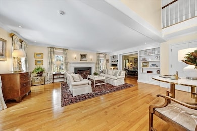
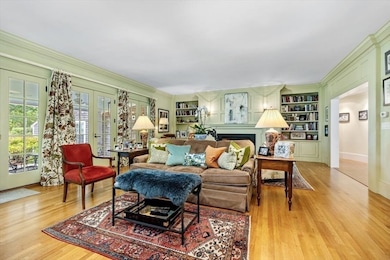
About This Home
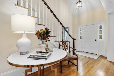
An extraordinary opportunity offering the best of Powder Point. This exceptional home, never before on the market, is set on a beautifully landscaped level acre of an exclusive lane leading to the water. This gracious home offers the perfect balance of privacy and accessibility, with 5800 sf, 5BR, 7 baths and was masterfully reimagined, expanded and renovated with exceptional detail and handsome custom finishes. A stunning sunlit kitchen features marble counters, butler's pantry, an oversized brick fireplace & French doors leading to a stone terrace and exquisite English gardens.Open living & family rooms with 2 additional fireplaces flow to an outdoor covered porch with iconic handmade gas lanterns and beautiful water views, magnificent sunsets and superb entertaining space. The expansive first floor main suite with garden views has full baths, walk-in closets, and a dressing room. Enjoy water access and a mooring - a rare opportunity blending timeless luxury with extraordinary charm.

Home Details
Home Type
- Single Family
Est. Annual Taxes
- $33,110
Year Built
- Built in 1986
Lot Details
- 0.99 Acre Lot
- Waterfront
- Property has an invisible fence for dogs
- Landscaped Professionally
- Sprinkler System
- Marsh on Lot
- Garden
- Property is zoned RC
Parking
- 3 Car Attached Garage
- Parking Storage or Cabinetry
- Side Facing Garage
Home Design
- Cape Cod Architecture
- Frame Construction
- Concrete Perimeter Foundation
Interior Spaces
- 5,822 Sq Ft Home
- Central Vacuum
- Wired For Sound
- Crown Molding
- Wainscoting
- Recessed Lighting
- Decorative Lighting
- Light Fixtures
- Pocket Doors
- French Doors
- Mud Room
- Family Room with Fireplace
- 3 Fireplaces
- Living Room with Fireplace
- Sitting Room
- Bonus Room
- Home Security System
- Laundry on upper level
Kitchen
- Stove
- Second Dishwasher
- Wine Cooler
- Stainless Steel Appliances
- Kitchen Island
- Solid Surface Countertops
- Pot Filler
- Fireplace in Kitchen
Flooring
- Wood
- Wall to Wall Carpet
- Marble
Bedrooms and Bathrooms
- 5 Bedrooms
- Primary Bedroom on Main
- Custom Closet System
- Walk-In Closet
- Dressing Area
- Soaking Tub
- Bathtub with Shower
- Separate Shower
Partially Finished Basement
- Walk-Out Basement
- Basement Fills Entire Space Under The House
- Interior Basement Entry
Outdoor Features
- Balcony
- Covered Deck
- Covered Patio or Porch
Location
- Property is near schools
Schools
- Chandler/Alden Elementary School
- DMS Middle School
- DHS High School
Utilities
- Forced Air Heating and Cooling System
- 4 Cooling Zones
- 4 Heating Zones
- Heating System Uses Natural Gas
- Gas Water Heater
- Private Sewer
Listing and Financial Details
- Assessor Parcel Number M:116 B:070 L:001,1000962
Community Details
Recreation
- Marina
- Golf Course Community
- Tennis Courts
- Community Pool
Additional Features
- No Home Owners Association
- Shops
Map
Home Values in the Area
Average Home Value in this Area
Tax History
| Year | Tax Paid | Tax Assessment Tax Assessment Total Assessment is a certain percentage of the fair market value that is determined by local assessors to be the total taxable value of land and additions on the property. | Land | Improvement |
|---|---|---|---|---|
| 2025 | $33,110 | $3,265,300 | $1,638,100 | $1,627,200 |
| 2024 | $32,282 | $3,208,900 | $1,575,600 | $1,633,300 |
| 2023 | $28,577 | $2,673,200 | $1,452,400 | $1,220,800 |
| 2022 | $25,896 | $2,016,800 | $996,000 | $1,020,800 |
| 2021 | $27,328 | $1,887,300 | $968,400 | $918,900 |
| 2020 | $27,932 | $1,905,300 | $857,700 | $1,047,600 |
| 2019 | $28,315 | $1,928,800 | $857,700 | $1,071,100 |
| 2018 | $28,002 | $1,847,100 | $828,700 | $1,018,400 |
| 2017 | $27,636 | $1,781,800 | $828,200 | $953,600 |
| 2016 | $27,332 | $1,757,700 | $804,100 | $953,600 |
| 2015 | $27,420 | $1,757,700 | $804,100 | $953,600 |
Property History
| Date | Event | Price | List to Sale | Price per Sq Ft |
|---|---|---|---|---|
| 08/28/2025 08/28/25 | For Sale | $4,850,000 | -- | $833 / Sq Ft |
Purchase History
| Date | Type | Sale Price | Title Company |
|---|---|---|---|
| Deed | $1,125,000 | -- | |
| Deed | $675,000 | -- |
Mortgage History
| Date | Status | Loan Amount | Loan Type |
|---|---|---|---|
| Open | $896,000 | No Value Available | |
| Closed | $900,000 | No Value Available | |
| Closed | $900,000 | Purchase Money Mortgage | |
| Previous Owner | $600,000 | No Value Available |
Source: MLS Property Information Network (MLS PIN)
MLS Number: 73423112
APN: DUXB-000116-000070-000001
Disclaimer: Certain information contained herein is derived from information provided by parties other than Homes.com. All information provided is deemed reliable, but is not guaranteed to be accurate and should be independently verified.
![]() The property listing data and information, or the Images, set forth herein were provided to MLS Property Information Network, Inc. from third party sources, including sellers, lessors and public records, and were compiled by MLS Property Information Network, Inc. The property listing data and information, and the Images, are for the personal, non-commercial use of consumers having a good faith interest in purchasing or leasing listed properties of the type displayed to them and may not be used for any purpose other than to identify prospective properties which such consumers may have a good faith interest in purchasing or leasing. MLS Property Information Network, Inc. and its subscribers disclaim any and all representations and warranties as to the accuracy of the property listing data and information, or as to the accuracy of any of the Images, set forth herein.
The property listing data and information, or the Images, set forth herein were provided to MLS Property Information Network, Inc. from third party sources, including sellers, lessors and public records, and were compiled by MLS Property Information Network, Inc. The property listing data and information, and the Images, are for the personal, non-commercial use of consumers having a good faith interest in purchasing or leasing listed properties of the type displayed to them and may not be used for any purpose other than to identify prospective properties which such consumers may have a good faith interest in purchasing or leasing. MLS Property Information Network, Inc. and its subscribers disclaim any and all representations and warranties as to the accuracy of the property listing data and information, or as to the accuracy of any of the Images, set forth herein.
- 387 Lot 2A Old Cove Rd
- 387 Lot 3A Old Cove Rd
- 387 Lot 4A Old Cove Rd
- 74 Abrams Hill Rd
- 236 Powder Point Ave
- 590 Washington St
- 535 Washington St
- 56 Chapel St
- 32 Harrison St
- 10 Hawthorn Hill
- Two Railroad Ave Unit 9
- Two Railroad Ave Unit 1
- Two Railroad Ave Unit 8
- Two Railroad Ave Unit 2
- 17 Winsor St
- 1141 Tremont St
- 260 Washington St
- 20 Possum Run
- 9 S Pasture Ln
- 71 Gurnet Rd
- 24 Pine Point Rd
- 10 Church St Unit 3
- 11 Friendship Ln
- 77 Gurnet Rd Unit 77
- 99 Bay Avenue (Weekly Summer Rent
- 191 Chestnut St Unit 1
- 364 Tremont St
- 300 Ocean St
- 128 Colonial Rd
- 26 Parsonage St Unit 5
- 1500 Ocean St Unit 1
- 15 Saginaw Ave
- 23 Everson Rd
- 19 Duffers Ln
- 2 Mile Brook Rd
- 178 Foster Ave
- 24 Post Rd
- 2093 Ocean St
- 18 Adams Rd
- 58 Main St Unit 2