Estimated Value: $1,528,000 - $3,011,000
3
Beds
3
Baths
2,194
Sq Ft
$1,093/Sq Ft
Est. Value
About This Home
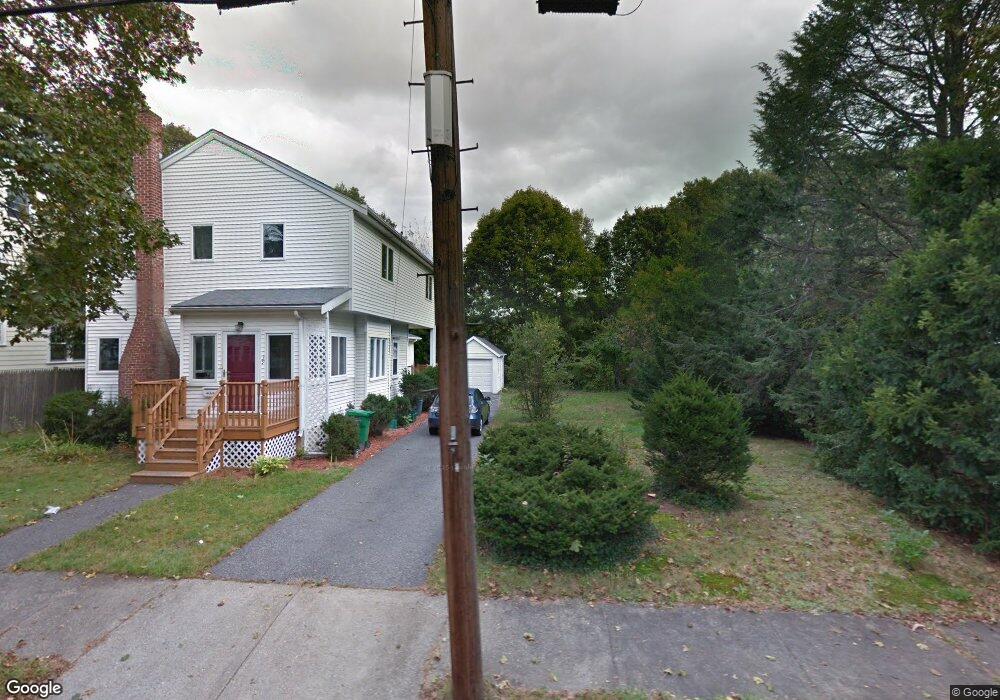
This home is located at 39 Carl St, Newton Highlands, MA 02461 and is currently estimated at $2,398,289, approximately $1,093 per square foot. 39 Carl St is a home located in Middlesex County with nearby schools including Countryside Elementary School, Charles E Brown Middle School, and Newton South High School.
Ownership History
Date
Name
Owned For
Owner Type
Purchase Details
Closed on
Mar 30, 2017
Sold by
Fridman Ludmila
Bought by
Schwartz Leon and Schwartz Rebecca A
Current Estimated Value
Purchase Details
Closed on
Jul 15, 1994
Sold by
Metzler Alexander
Bought by
Friedman Ludmila and Fridman Alexander
Purchase Details
Closed on
Mar 23, 1990
Sold by
Bouchard Lisa F
Bought by
Metsler Alexander
Purchase Details
Closed on
Nov 12, 1987
Sold by
Mcglynn Edward G
Bought by
Bouchard James P
Create a Home Valuation Report for This Property
The Home Valuation Report is an in-depth analysis detailing your home's value as well as a comparison with similar homes in the area
Home Values in the Area
Average Home Value in this Area
Purchase History
| Date | Buyer | Sale Price | Title Company |
|---|---|---|---|
| Schwartz Leon | $750,000 | -- | |
| Friedman Ludmila | $155,000 | -- | |
| Metsler Alexander | $190,800 | -- | |
| Bouchard James P | $189,000 | -- |
Source: Public Records
Mortgage History
| Date | Status | Borrower | Loan Amount |
|---|---|---|---|
| Previous Owner | Bouchard James P | $180,000 | |
| Previous Owner | Bouchard James P | $197,000 |
Source: Public Records
Tax History Compared to Growth
Tax History
| Year | Tax Paid | Tax Assessment Tax Assessment Total Assessment is a certain percentage of the fair market value that is determined by local assessors to be the total taxable value of land and additions on the property. | Land | Improvement |
|---|---|---|---|---|
| 2025 | $24,006 | $2,449,600 | $932,400 | $1,517,200 |
| 2024 | $23,212 | $2,378,300 | $905,200 | $1,473,100 |
| 2023 | $22,364 | $2,196,900 | $696,400 | $1,500,500 |
| 2022 | $21,400 | $2,034,200 | $644,800 | $1,389,400 |
| 2021 | $20,650 | $1,919,100 | $608,300 | $1,310,800 |
| 2020 | $20,035 | $1,919,100 | $608,300 | $1,310,800 |
| 2019 | $19,470 | $1,863,200 | $590,600 | $1,272,600 |
| 2018 | $7,882 | $728,500 | $456,300 | $272,200 |
| 2017 | $7,643 | $687,300 | $430,500 | $256,800 |
| 2016 | $7,309 | $642,300 | $402,300 | $240,000 |
| 2015 | $6,969 | $600,300 | $376,000 | $224,300 |
Source: Public Records
Map
Nearby Homes
- 51 Carl St
- 36 Roland St
- 128 Charlemont St
- 15 Buff Cir
- 183 Oak St Unit 307
- 183 Oak St Unit 404
- 183 Oak St Unit 205
- 415 Dedham St Unit D
- 36 Cannon St
- 1 Williams Ct
- 66 Linden St
- 250 Woodcliff Rd
- 12 Shawmut Park
- 18-20 Pennsylvania Ave Unit 18
- 20 Pennsylvania Ave
- 20 Pennsylvania Ave Unit 20
- 27 Indiana Terrace Unit 29
- 207 Nahanton St Unit 207
- 1308 Walnut St
- 54 Indiana Terrace