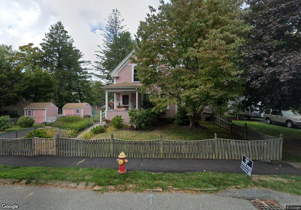
39 Cherry St Whitman, MA 02382
Estimated Value: $542,000 - $738,000
3
Beds
2
Baths
1,641
Sq Ft
$364/Sq Ft
Est. Value
About This Home
This home is located at 39 Cherry St, Whitman, MA 02382 and is currently estimated at $597,410, approximately $364 per square foot. 39 Cherry St is a home located in Plymouth County with nearby schools including St Bridget School.
Ownership History
Date
Name
Owned For
Owner Type
Purchase Details
Closed on
Jul 8, 2019
Sold by
Marshall Ellen M and Wolcott Judith G
Bought by
39 Cherry Street Rt
Current Estimated Value
Purchase Details
Closed on
May 19, 2010
Sold by
Marshall Ellen M and Pery-Muise Ellen
Bought by
Marshall Ellen M and Wolcott Judith G
Purchase Details
Closed on
Jun 29, 1992
Sold by
Twomey Lynne F
Bought by
Perry-Muise Ellen
Create a Home Valuation Report for This Property
The Home Valuation Report is an in-depth analysis detailing your home's value as well as a comparison with similar homes in the area
Home Values in the Area
Average Home Value in this Area
Purchase History
| Date | Buyer | Sale Price | Title Company |
|---|---|---|---|
| 39 Cherry Street Rt | -- | -- | |
| Marshall Ellen M | -- | -- | |
| Perry-Muise Ellen | $111,450 | -- |
Source: Public Records
Mortgage History
| Date | Status | Borrower | Loan Amount |
|---|---|---|---|
| Previous Owner | Perry-Muise Ellen | $50,000 | |
| Previous Owner | Perry-Muise Ellen | $50,000 | |
| Previous Owner | Perry-Muise Ellen | $128,000 |
Source: Public Records
Tax History
| Year | Tax Paid | Tax Assessment Tax Assessment Total Assessment is a certain percentage of the fair market value that is determined by local assessors to be the total taxable value of land and additions on the property. | Land | Improvement |
|---|---|---|---|---|
| 2025 | $6,105 | $465,300 | $203,300 | $262,000 |
| 2024 | $5,654 | $443,800 | $199,300 | $244,500 |
| 2023 | $5,421 | $399,500 | $172,800 | $226,700 |
| 2022 | $5,354 | $367,700 | $157,100 | $210,600 |
| 2021 | $5,231 | $337,500 | $144,400 | $193,100 |
| 2020 | $5,139 | $324,200 | $137,500 | $186,700 |
| 2019 | $4,837 | $314,500 | $137,500 | $177,000 |
| 2018 | $4,288 | $281,300 | $129,600 | $151,700 |
| 2017 | $4,242 | $281,300 | $129,600 | $151,700 |
| 2016 | $4,061 | $260,500 | $122,800 | $137,700 |
| 2015 | $3,678 | $235,600 | $108,000 | $127,600 |
Source: Public Records
Map
Nearby Homes
- 170 Pleasant St
- 291 Raynor Ave
- 608 Plymouth St
- 289 Commercial St
- 147 South Ave
- 110 South Ave
- 48 Day St
- 8 Laurel St
- 214 Winter St
- 53 Temple St
- 95 Temple St
- 10 Proud Foot Way
- 135-137 Temple St
- 42 Rock St
- 5 Alpine St
- 150 Harvard St
- 14 Birch Bottom Cir
- 22 Old Coach Rd
- 229 Washington Terrace
- 159 Auburn St
- 31 Cherry St
- 47 Cherry St
- 46 Lazel St
- 52 Lazel St
- 36 Cherry St
- 44 Cherry St
- 23 Cherry St
- 60 Lazel St
- 125 Raynor Ave
- 30 Cherry St Unit 1
- 115 Raynor Ave
- 39 Thayer Ave
- 45 Thayer Ave
- 17-B Cherry (Includes Heat) Unit B
- F2 Auburnville Way F2 Unit F2
- 30 Lazel St
- 135 Raynor Ave
- 17 Cherry Street Heat Included Unit A
- 17 Cherry St
- 17 Cherry St Unit 2
Your Personal Tour Guide
Ask me questions while you tour the home.