Estimated Value: $1,014,000 - $1,388,506
4
Beds
5
Baths
3,585
Sq Ft
$334/Sq Ft
Est. Value
About This Home
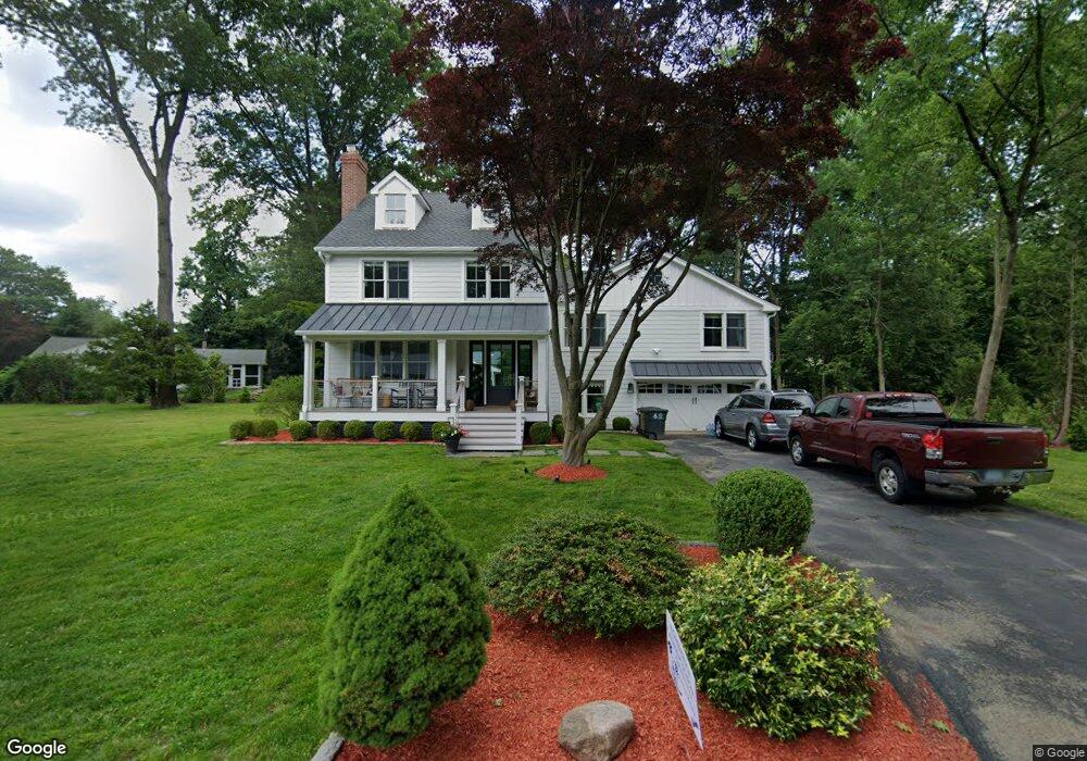
This home is located at 39 Club Rd, Stamford, CT 06905 and is currently estimated at $1,198,877, approximately $334 per square foot. 39 Club Rd is a home located in Fairfield County with nearby schools including Davenport Ridge Elementary School, Rippowam Middle School, and Stamford High School.
Ownership History
Date
Name
Owned For
Owner Type
Purchase Details
Closed on
Oct 15, 2012
Sold by
Lynch Cora M
Bought by
Lynch Cora M and Omeara Paul
Current Estimated Value
Home Financials for this Owner
Home Financials are based on the most recent Mortgage that was taken out on this home.
Original Mortgage
$417,000
Outstanding Balance
$180,831
Interest Rate
3.59%
Mortgage Type
New Conventional
Estimated Equity
$1,018,046
Purchase Details
Closed on
Jan 18, 2000
Sold by
Brucoli John M
Bought by
Lynch Cora M
Create a Home Valuation Report for This Property
The Home Valuation Report is an in-depth analysis detailing your home's value as well as a comparison with similar homes in the area
Home Values in the Area
Average Home Value in this Area
Purchase History
| Date | Buyer | Sale Price | Title Company |
|---|---|---|---|
| Lynch Cora M | -- | -- | |
| Lynch Cora M | -- | -- | |
| Lynch Cora M | -- | -- | |
| Lynch Cora M | $375,000 | -- | |
| Lynch Cora M | $375,000 | -- |
Source: Public Records
Mortgage History
| Date | Status | Borrower | Loan Amount |
|---|---|---|---|
| Open | Lynch Cora M | $417,000 | |
| Closed | Lynch Cora M | $417,000 | |
| Previous Owner | Lynch Cora M | $300,700 |
Source: Public Records
Tax History Compared to Growth
Tax History
| Year | Tax Paid | Tax Assessment Tax Assessment Total Assessment is a certain percentage of the fair market value that is determined by local assessors to be the total taxable value of land and additions on the property. | Land | Improvement |
|---|---|---|---|---|
| 2025 | $16,592 | $701,270 | $298,120 | $403,150 |
| 2024 | $16,227 | $701,270 | $298,120 | $403,150 |
| 2023 | $16,865 | $678,410 | $298,120 | $380,290 |
| 2022 | $13,642 | $510,160 | $231,950 | $278,210 |
| 2021 | $11,834 | $447,410 | $231,950 | $215,460 |
| 2020 | $10,503 | $407,570 | $231,950 | $175,620 |
| 2019 | $10,503 | $407,570 | $231,950 | $175,620 |
| 2018 | $10,116 | $407,570 | $231,950 | $175,620 |
| 2017 | $9,473 | $364,330 | $215,920 | $148,410 |
| 2016 | $9,207 | $364,330 | $215,920 | $148,410 |
| 2015 | $8,966 | $364,330 | $215,920 | $148,410 |
| 2014 | $8,667 | $364,330 | $215,920 | $148,410 |
Source: Public Records
Map
Nearby Homes
- 393 Upper Haig Ave
- 44 Brundage St
- 83 Mulberry St
- 31 Gray Farms Rd
- 14 Barmore Dr
- 1148 Hope St
- 1157 Hope St
- 22 Hastings Ln
- 27 Emma Rd
- 970 Hope St Unit 4J
- 21 Nichols Ave
- 23 Oenoke Place
- 24 Haig Ave
- 34 Bradley Place
- 17 Oenoke Place
- 172 Joffre Ave
- 900 Hope St Unit 8C
- 910 Hope St Unit 5B
- 56 Bradley Place
- 7 the Reserve at Sterling Ridge