
Seller's Agent in 2025
Alison Behlman
Tier 1 Real Estate
(860) 806-0665
3 in this area
12 Total Sales
Estimated Value: $275,000 - $310,203
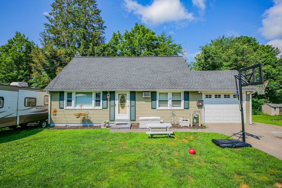
Well-maintained 3-bedroom, 1-bath Cape located in a quiet neighborhood in Winchester. Features include dining area with hardwood floors, natural gas heat, and a top notch alarm system. Roof is less than 10 years old. Functional layout with flexible living space and a manageable yard for outdoor enjoyment. Sale is contingent upon successful purchase of seller's new property.
Last Agent to Sell the Property
Tier 1 Real Estate License #RES.0802885 Listed on: 07/09/2025
We collect this data history from publicly available records. To have your information removed, we recommend requesting removal directly through your county’s website.
We collect this data history from publicly available records. To have your information removed, we recommend requesting removal directly through your county’s website.
| Date | Buyer | Sale Price | Title Company |
|---|---|---|---|
| $279,000 | -- | ||
| -- | -- | ||
| -- | -- | ||
| -- | -- | ||
| $110,000 | -- | ||
| $93,000 | -- |
We collect this data history from publicly available records. To have your information removed, we recommend requesting removal directly through your county’s website.
| Date | Status | Borrower | Loan Amount |
|---|---|---|---|
| Open | $251,910 | ||
| Previous Owner | $103,700 | ||
| Previous Owner | $32,000 | ||
| Previous Owner | $30,135 |
We collect this data history from publicly available records. To have your information removed, we recommend requesting removal directly through your county’s website.
| Date | Event | Price | List to Sale | Price per Sq Ft |
|---|---|---|---|---|
| 09/12/2025 09/12/25 | Sold | $279,900 | 0.0% | $237 / Sq Ft |
| 07/09/2025 07/09/25 | For Sale | $279,900 | -- | $237 / Sq Ft |
We collect this data history from publicly available records. To have your information removed, we recommend requesting removal directly through your county’s website.
| Year | Tax Paid | Tax Assessment Tax Assessment Total Assessment is a certain percentage of the fair market value that is determined by local assessors to be the total taxable value of land and additions on the property. | Land | Improvement |
|---|---|---|---|---|
| 2025 | $4,396 | $150,710 | $32,830 | $117,880 |
| 2024 | $4,105 | $150,710 | $32,830 | $117,880 |
| 2023 | $3,977 | $150,710 | $32,830 | $117,880 |
| 2022 | $3,395 | $101,220 | $23,800 | $77,420 |
| 2021 | $3,395 | $101,220 | $23,800 | $77,420 |
| 2020 | $3,395 | $101,220 | $23,800 | $77,420 |
| 2019 | $3,395 | $101,220 | $23,800 | $77,420 |
| 2018 | $3,395 | $101,220 | $23,800 | $77,420 |
| 2017 | $3,296 | $98,280 | $23,800 | $74,480 |
| 2016 | $3,296 | $98,280 | $23,800 | $74,480 |
| 2015 | $3,214 | $98,280 | $23,800 | $74,480 |
| 2014 | $3,136 | $98,280 | $23,800 | $74,480 |
Seller's Agent in 2025
Alison Behlman
Tier 1 Real Estate
(860) 806-0665
3 in this area
12 Total Sales
Buyer's Agent in 2025
Dana Pinkerton
Regency Real Estate, LLC
(475) 471-1044
1 in this area
36 Total Sales
Source: SmartMLS
MLS Number: 24112108
APN: WINC-000116-000079-000024Z
Disclaimer: Certain information contained herein is derived from information provided by parties other than Homes.com. All information provided is deemed reliable, but is not guaranteed to be accurate and should be independently verified.
![]() IDX information is provided exclusively for personal, non-commercial use, and may not be used for any purpose other than to identify prospective properties consumers may be interested in purchasing. Information is deemed reliable but not guaranteed.
IDX information is provided exclusively for personal, non-commercial use, and may not be used for any purpose other than to identify prospective properties consumers may be interested in purchasing. Information is deemed reliable but not guaranteed.
Ask me questions while you tour the home.