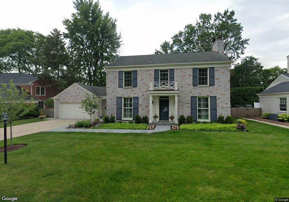
39 Deming Ln Unit Bldg-Unit Grosse Pointe Farms, MI 48236
Estimated Value: $807,000 - $931,000
--
Bed
4
Baths
3,098
Sq Ft
$283/Sq Ft
Est. Value
About This Home
This home is located at 39 Deming Ln Unit Bldg-Unit, Grosse Pointe Farms, MI 48236 and is currently estimated at $877,888, approximately $283 per square foot. 39 Deming Ln Unit Bldg-Unit is a home located in Wayne County with nearby schools including Richard Elementary School, Brownell Middle School, and Grosse Pointe South High School.
Ownership History
Date
Name
Owned For
Owner Type
Purchase Details
Closed on
Jul 23, 2020
Sold by
Saadi Abdul Amir Al
Bought by
Albright John S and Albright Anne L
Current Estimated Value
Home Financials for this Owner
Home Financials are based on the most recent Mortgage that was taken out on this home.
Original Mortgage
$75,000
Outstanding Balance
$65,974
Interest Rate
2.8%
Mortgage Type
New Conventional
Estimated Equity
$811,914
Purchase Details
Closed on
Nov 30, 2004
Sold by
Rodger Cassandra Z
Bought by
Alsaadi Abdul Amir
Create a Home Valuation Report for This Property
The Home Valuation Report is an in-depth analysis detailing your home's value as well as a comparison with similar homes in the area
Home Values in the Area
Average Home Value in this Area
Purchase History
| Date | Buyer | Sale Price | Title Company |
|---|---|---|---|
| Albright John S | $540,000 | Ata National Title | |
| Albright John S | $540,000 | Ata National Title | |
| Alsaadi Abdul Amir | -- | -- |
Source: Public Records
Mortgage History
| Date | Status | Borrower | Loan Amount |
|---|---|---|---|
| Open | Albright John S | $75,000 | |
| Closed | Albright John S | $75,000 | |
| Open | Albright John S | $300,000 | |
| Closed | Albright John S | $300,000 |
Source: Public Records
Tax History Compared to Growth
Tax History
| Year | Tax Paid | Tax Assessment Tax Assessment Total Assessment is a certain percentage of the fair market value that is determined by local assessors to be the total taxable value of land and additions on the property. | Land | Improvement |
|---|---|---|---|---|
| 2025 | $8,972 | $376,700 | $0 | $0 |
| 2024 | $8,972 | $353,700 | $0 | $0 |
| 2023 | $8,220 | $340,200 | $0 | $0 |
| 2022 | $8,220 | $308,800 | $0 | $0 |
| 2021 | $15,389 | $305,000 | $0 | $0 |
| 2019 | $17,839 | $332,500 | $0 | $0 |
| 2018 | $7,324 | $324,500 | $0 | $0 |
| 2017 | $19,009 | $319,800 | $0 | $0 |
| 2016 | $16,349 | $298,400 | $0 | $0 |
| 2015 | $26,384 | $286,900 | $0 | $0 |
| 2013 | $25,560 | $255,600 | $0 | $0 |
| 2012 | $6,665 | $250,600 | $51,300 | $199,300 |
Source: Public Records
Map
Nearby Homes
- 105 Lake Shore Rd
- 76 Grosse Pointe Blvd
- 65 Mapleton Rd
- 29 Fisher Rd
- 93 Merriweather Rd
- 166 Lewiston Rd
- 355 Lincoln Rd
- 277 Lincoln Rd
- 11 Dodge Place
- 201 Mcmillan Rd
- 180 Fisher Rd
- 213 Muir Rd
- 130 Merriweather Rd
- 17680 E Jefferson Ave
- 296 Rivard Blvd
- 425 Rivard Blvd
- 233 Mcmillan Rd
- 240 Mckinley Ave
- 4 Cameron Place
- 216 Ridge Rd