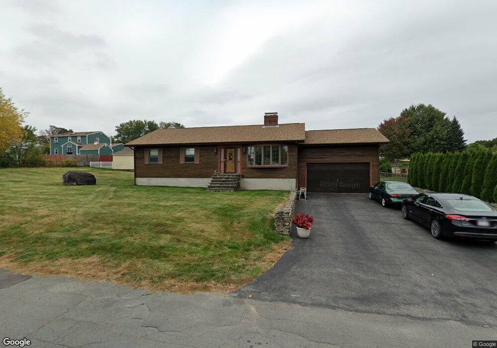
39 Derry Rd Methuen, MA 01844
The East End NeighborhoodEstimated Value: $637,000 - $696,000
3
Beds
3
Baths
2,860
Sq Ft
$230/Sq Ft
Est. Value
About This Home
This home is located at 39 Derry Rd, Methuen, MA 01844 and is currently estimated at $659,048, approximately $230 per square foot. 39 Derry Rd is a home located in Essex County with nearby schools including Timony Grammar School, Methuen High School, and Community Day Charter Public School - Gateway.
Ownership History
Date
Name
Owned For
Owner Type
Purchase Details
Closed on
Jan 31, 2020
Sold by
Deparis Elaine
Bought by
Turner Lindsay and Deparis Elaine
Current Estimated Value
Purchase Details
Closed on
Apr 29, 1991
Sold by
Michaud Norman
Bought by
Deparis Elaine C
Home Financials for this Owner
Home Financials are based on the most recent Mortgage that was taken out on this home.
Original Mortgage
$109,500
Interest Rate
9.41%
Mortgage Type
Purchase Money Mortgage
Create a Home Valuation Report for This Property
The Home Valuation Report is an in-depth analysis detailing your home's value as well as a comparison with similar homes in the area
Home Values in the Area
Average Home Value in this Area
Purchase History
| Date | Buyer | Sale Price | Title Company |
|---|---|---|---|
| Turner Lindsay | -- | None Available | |
| Turner Lindsay | -- | None Available | |
| Turner Lindsay | -- | None Available | |
| Deparis Elaine C | $149,500 | -- | |
| Deparis Elaine C | $149,500 | -- |
Source: Public Records
Mortgage History
| Date | Status | Borrower | Loan Amount |
|---|---|---|---|
| Previous Owner | Deparis Elaine C | $95,000 | |
| Previous Owner | Deparis Elaine C | $110,500 | |
| Previous Owner | Deparis Elaine C | $109,500 |
Source: Public Records
Tax History
| Year | Tax Paid | Tax Assessment Tax Assessment Total Assessment is a certain percentage of the fair market value that is determined by local assessors to be the total taxable value of land and additions on the property. | Land | Improvement |
|---|---|---|---|---|
| 2025 | $5,887 | $556,400 | $213,400 | $343,000 |
| 2024 | $5,430 | $500,000 | $194,700 | $305,300 |
| 2023 | $5,134 | $438,800 | $173,000 | $265,800 |
| 2022 | $4,942 | $378,700 | $144,200 | $234,500 |
| 2021 | $4,631 | $351,100 | $137,000 | $214,100 |
| 2020 | $4,614 | $343,300 | $137,000 | $206,300 |
| 2019 | $4,392 | $309,500 | $122,600 | $186,900 |
| 2018 | $4,278 | $299,800 | $122,600 | $177,200 |
| 2017 | $4,130 | $281,900 | $122,600 | $159,300 |
| 2016 | $3,948 | $266,600 | $115,400 | $151,200 |
| 2015 | $3,821 | $261,700 | $115,400 | $146,300 |
Source: Public Records
Map
Nearby Homes
- 30 Anderson Dr
- 51 Ford St Unit A
- 5 Pilgrim Cir Unit C
- 396 Oak St
- 68 Ashford St
- 128 Pleasant Valley St
- 10 Fenwick Cir
- 16 Christopher Dr Unit 38
- 45 Christopher Dr Unit 106
- 201 Aberdeen Rd
- 17 Ferry Rd
- 7 Erhardt Terrace
- 27 Russell Farm Dr
- 65 Arthur St
- 1 Riverview Blvd Unit 8-203
- 1 Riverview Blvd Unit 1:209
- 1 Riverview Blvd Unit 4-203
- 18 Erhardt Terrace
- 6 Ferry Rd
- 12 Annette St
Your Personal Tour Guide
Ask me questions while you tour the home.