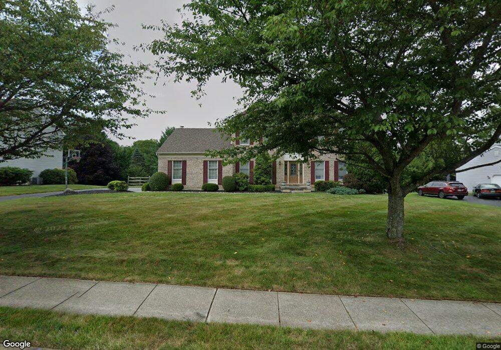
39 Fox Brook Ln Thornton, PA 19373
Estimated Value: $866,027 - $946,000
4
Beds
3
Baths
2,912
Sq Ft
$312/Sq Ft
Est. Value
About This Home
This home is located at 39 Fox Brook Ln, Thornton, PA 19373 and is currently estimated at $909,257, approximately $312 per square foot. 39 Fox Brook Ln is a home located in Delaware County with nearby schools including Westtown-Thornbury Elementary School, Stetson Middle School, and Bayard Rustin High School.
Ownership History
Date
Name
Owned For
Owner Type
Purchase Details
Closed on
May 12, 2006
Sold by
Sparta John A
Bought by
Better John S and Better Shari L
Current Estimated Value
Home Financials for this Owner
Home Financials are based on the most recent Mortgage that was taken out on this home.
Original Mortgage
$165,000
Outstanding Balance
$96,758
Interest Rate
6.62%
Mortgage Type
Purchase Money Mortgage
Estimated Equity
$812,499
Create a Home Valuation Report for This Property
The Home Valuation Report is an in-depth analysis detailing your home's value as well as a comparison with similar homes in the area
Home Values in the Area
Average Home Value in this Area
Purchase History
| Date | Buyer | Sale Price | Title Company |
|---|---|---|---|
| Better John S | $512,000 | Commonwealth Land Title Insu |
Source: Public Records
Mortgage History
| Date | Status | Borrower | Loan Amount |
|---|---|---|---|
| Open | Better John S | $165,000 |
Source: Public Records
Tax History
| Year | Tax Paid | Tax Assessment Tax Assessment Total Assessment is a certain percentage of the fair market value that is determined by local assessors to be the total taxable value of land and additions on the property. | Land | Improvement |
|---|---|---|---|---|
| 2025 | $7,407 | $565,810 | $155,460 | $410,350 |
| 2024 | $7,407 | $565,810 | $155,460 | $410,350 |
| 2023 | $7,318 | $565,810 | $155,460 | $410,350 |
| 2022 | $7,081 | $565,810 | $155,460 | $410,350 |
| 2021 | $11,125 | $565,810 | $155,460 | $410,350 |
| 2020 | $6,330 | $291,410 | $92,540 | $198,870 |
| 2019 | $6,276 | $291,410 | $92,540 | $198,870 |
| 2018 | $6,064 | $291,410 | $0 | $0 |
| 2017 | $5,919 | $291,410 | $0 | $0 |
| 2016 | $1,599 | $291,410 | $0 | $0 |
| 2015 | $1,632 | $291,410 | $0 | $0 |
| 2014 | $1,599 | $291,410 | $0 | $0 |
Source: Public Records
Map
Nearby Homes
- 186 Dilworthtown Rd
- 575 Woodhaven Rd
- 38 James Cloud
- 16 Creekview Cir
- 257 Glen Mills Rd Unit C
- 257 Glen Mills Rd Unit B
- 257 Glen Mills Rd
- 250 Glen Mills Rd
- 255 Glen Mills Rd
- 34 Oakland Rd Unit C2
- 411 Webb Rd
- Lot 3 149 Governor Markham Cheslen
- 101 Bellefair Ln
- 1015 Adams Way
- Lot 2 145 Governor Markham Cheslen
- 0 Baltimore Pike
- 119 Huntteam Ln
- 779 Concord Rd
- 51 Scott Rd
- 1707 Painters Crossing Unit 1707
- 37 Fox Brook Ln
- 41 Fox Brook Ln
- 8 Westover Dr
- 6 Westover Dr
- 34 Fox Brook Ln
- 35 Fox Brook Ln
- 36 Fox Brook Ln
- 32 Fox Brook Ln
- 4 Westover Dr
- 9 Westover Dr
- 36 Westtown Rd
- 30 Fox Brook Ln
- 33 Fox Brook Ln
- 2 Westover Dr
- 7 Westover Dr
- 5 Westover Dr
- 28 Fox Brook Ln
- 3 Westover Dr
- 26 Westtown Rd
- 40 Westtown Rd
Your Personal Tour Guide
Ask me questions while you tour the home.