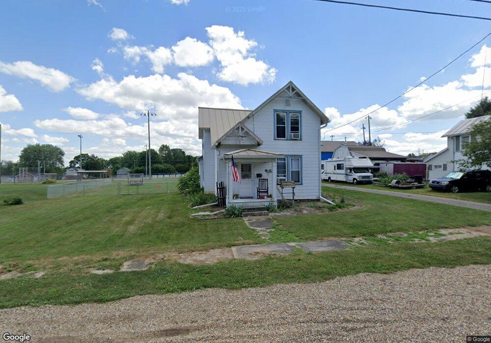
39 High St Hayesville, OH 44838
Estimated Value: $120,752 - $184,000
3
Beds
1
Bath
1,597
Sq Ft
$101/Sq Ft
Est. Value
About This Home
This home is located at 39 High St, Hayesville, OH 44838 and is currently estimated at $160,938, approximately $100 per square foot. 39 High St is a home with nearby schools including Hillsdale Elementary School, Hillsdale Middle School, and Hillsdale High School.
Ownership History
Date
Name
Owned For
Owner Type
Purchase Details
Closed on
Mar 29, 2024
Sold by
Blough Aaron B and Blough Constance Michael
Bought by
Constance Michael D and Constance Mallory L
Current Estimated Value
Home Financials for this Owner
Home Financials are based on the most recent Mortgage that was taken out on this home.
Original Mortgage
$90,333
Outstanding Balance
$87,666
Interest Rate
6.9%
Mortgage Type
FHA
Estimated Equity
$73,272
Purchase Details
Closed on
May 11, 2009
Sold by
Chepote Beth Ann
Bought by
Blough Aaron B
Purchase Details
Closed on
Jan 1, 1990
Sold by
Allenbaugh Kenneth F
Bought by
Chepote Beth Ann
Create a Home Valuation Report for This Property
The Home Valuation Report is an in-depth analysis detailing your home's value as well as a comparison with similar homes in the area
Purchase History
We collect this data history from publicly available records. To have your information removed, we recommend requesting removal directly through your county’s website.
| Date | Buyer | Sale Price | Title Company |
|---|---|---|---|
| Constance Michael D | -- | Castle Real Estate Title | |
| Blough Aaron B | $60,700 | -- | |
| Chepote Beth Ann | -- | -- |
Source: Public Records
Mortgage History
We collect this data history from publicly available records. To have your information removed, we recommend requesting removal directly through your county’s website.
| Date | Status | Borrower | Loan Amount |
|---|---|---|---|
| Open | Constance Michael D | $90,333 |
Source: Public Records
Tax History
| Year | Tax Paid | Tax Assessment Tax Assessment Total Assessment is a certain percentage of the fair market value that is determined by local assessors to be the total taxable value of land and additions on the property. | Land | Improvement |
|---|---|---|---|---|
| 2025 | $1,101 | $32,120 | $4,310 | $27,810 |
| 2024 | $1,101 | $32,120 | $4,310 | $27,810 |
| 2023 | $1,101 | $32,120 | $4,310 | $27,810 |
| 2022 | $1,042 | $24,710 | $3,320 | $21,390 |
| 2021 | $1,043 | $24,710 | $3,320 | $21,390 |
| 2020 | $978 | $24,710 | $3,320 | $21,390 |
| 2019 | $881 | $21,700 | $3,430 | $18,270 |
| 2018 | $876 | $21,700 | $3,430 | $18,270 |
| 2017 | $870 | $21,700 | $3,430 | $18,270 |
| 2016 | $764 | $18,870 | $2,990 | $15,880 |
| 2015 | $755 | $18,870 | $2,990 | $15,880 |
| 2013 | $897 | $22,210 | $2,990 | $19,220 |
Source: Public Records
Map
Nearby Homes
- 150 E Main St
- 7 Main St
- 83 S Mechanic St
- 820 County Road 30a
- 0 County Road 1754
- 1203 T R 1714
- 946 Township Road 2206
- 2184 State Route 179
- 2195 Township Road 405
- 291 County Road 2000
- 1015 Township Road 1696
- 1589 State Route 511
- 1659 State Route 89
- 1105 Township Road 1806
- 1166 County Road 2075
- 496 Township Road 2402
- 1172 County Road 2075
- 609 Ohio 95
- 438 Township Road 1500
- 0 Berwyck Ct
Your Personal Tour Guide
Ask me questions while you tour the home.