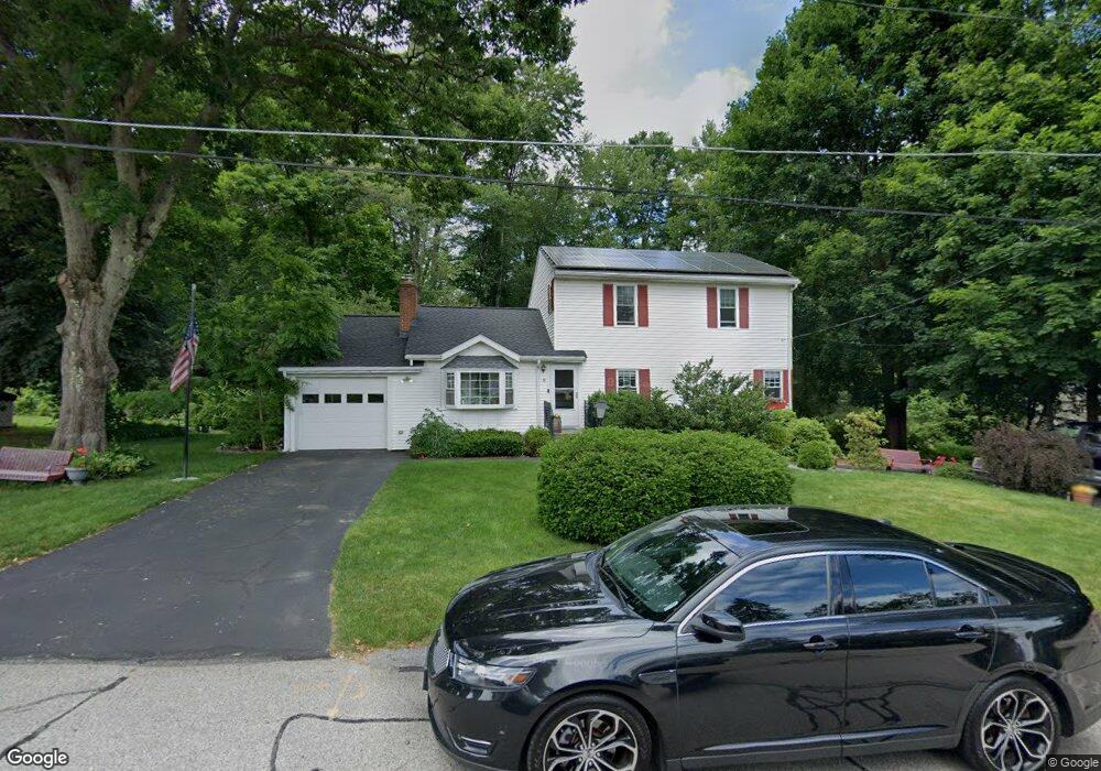
39 Hollywood Dr North Grafton, MA 01536
Estimated Value: $538,000 - $648,000
4
Beds
4
Baths
1,656
Sq Ft
$346/Sq Ft
Est. Value
About This Home
This home is located at 39 Hollywood Dr, North Grafton, MA 01536 and is currently estimated at $573,291, approximately $346 per square foot. 39 Hollywood Dr is a home located in Worcester County with nearby schools including Grafton High School, St Stephen Elementary School, and Al-Hamra Academy.
Ownership History
Date
Name
Owned For
Owner Type
Purchase Details
Closed on
Jun 12, 2025
Sold by
Oevermann Urlich and Oevermann Kari L
Bought by
Oevermann Ft and Oevermann
Current Estimated Value
Purchase Details
Closed on
Dec 18, 1987
Sold by
Hooper Rand N
Bought by
Desrosiers Paul R
Create a Home Valuation Report for This Property
The Home Valuation Report is an in-depth analysis detailing your home's value as well as a comparison with similar homes in the area
Home Values in the Area
Average Home Value in this Area
Purchase History
| Date | Buyer | Sale Price | Title Company |
|---|---|---|---|
| Oevermann Ft | -- | None Available | |
| Oevermann Ft | -- | None Available | |
| Desrosiers Paul R | $134,500 | -- |
Source: Public Records
Mortgage History
| Date | Status | Borrower | Loan Amount |
|---|---|---|---|
| Previous Owner | Desrosiers Paul R | $197,100 | |
| Previous Owner | Desrosiers Paul R | $176,000 |
Source: Public Records
Tax History Compared to Growth
Tax History
| Year | Tax Paid | Tax Assessment Tax Assessment Total Assessment is a certain percentage of the fair market value that is determined by local assessors to be the total taxable value of land and additions on the property. | Land | Improvement |
|---|---|---|---|---|
| 2025 | $7,482 | $536,700 | $173,000 | $363,700 |
| 2024 | $7,348 | $513,500 | $164,800 | $348,700 |
| 2023 | $6,919 | $440,400 | $164,800 | $275,600 |
| 2022 | $6,472 | $383,400 | $141,500 | $241,900 |
| 2021 | $6,183 | $359,900 | $128,600 | $231,300 |
| 2020 | $5,895 | $357,300 | $128,600 | $228,700 |
| 2019 | $5,831 | $350,000 | $124,900 | $225,100 |
| 2018 | $5,700 | $343,600 | $124,200 | $219,400 |
| 2017 | $5,515 | $336,300 | $116,900 | $219,400 |
| 2016 | $5,003 | $298,700 | $93,900 | $204,800 |
| 2015 | $4,996 | $302,800 | $92,800 | $210,000 |
| 2014 | $4,676 | $306,400 | $109,600 | $196,800 |
Source: Public Records
Map
Nearby Homes
- 11 Hovey Pond Dr Unit 11
- 194 Worcester St
- 14 Northgate Ct Unit 14
- 17 Hingham Rd
- 4 Westboro Rd
- 30 Falmouth Dr
- 69 Cortland Grove Dr Unit 69
- 51 Cortland Grove Dr Unit 51
- 0 East St
- 39 Pointe Rok Dr Unit 39
- 76 Samuel Dr
- 21 Lordvale Blvd Unit 406
- 44 Meadow Ln
- 1 Purinton St
- 95 Pineland Ave
- 4 Winslow Ln Unit 1410
- 5 Lincoln Ln Unit 5
- 32 Clews St
- 46 John Dr Unit 46
- 28 Lincoln Ln