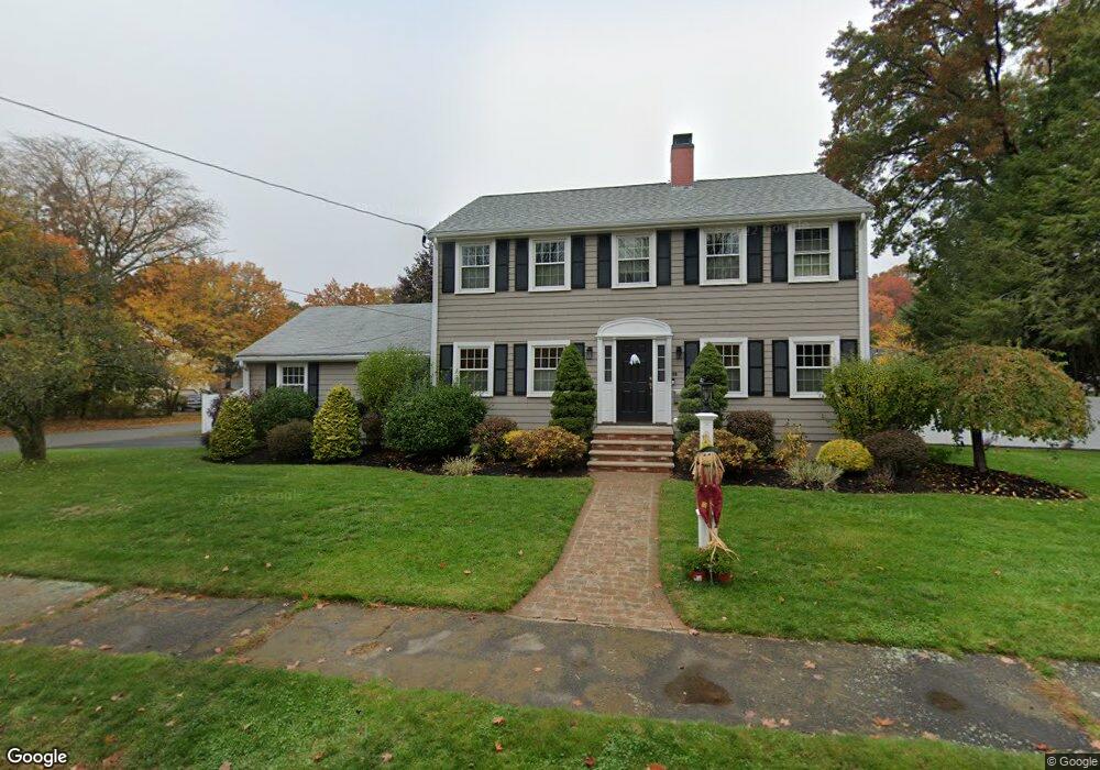
39 Maple Ridge Rd Reading, MA 01867
Estimated Value: $1,043,000 - $1,074,102
4
Beds
3
Baths
2,210
Sq Ft
$482/Sq Ft
Est. Value
About This Home
This home is located at 39 Maple Ridge Rd, Reading, MA 01867 and is currently estimated at $1,064,526, approximately $481 per square foot. 39 Maple Ridge Rd is a home located in Middlesex County with nearby schools including Joshua Eaton Elementary School, Walter S. Parker Middle School, and Reading Memorial High School.
Ownership History
Date
Name
Owned For
Owner Type
Purchase Details
Closed on
Oct 3, 2020
Sold by
Amaru Charlie J and Amaru Donna M
Bought by
Amaru Ft and Amaru
Current Estimated Value
Purchase Details
Closed on
Aug 25, 2004
Sold by
Mary G Amaru 1992 Ret and Amaru
Bought by
Amaru Charles J and Amaru Donna M
Purchase Details
Closed on
Oct 16, 1972
Bought by
Amaru Charlie and Amaru Donna M
Create a Home Valuation Report for This Property
The Home Valuation Report is an in-depth analysis detailing your home's value as well as a comparison with similar homes in the area
Home Values in the Area
Average Home Value in this Area
Purchase History
| Date | Buyer | Sale Price | Title Company |
|---|---|---|---|
| Amaru Ft | -- | None Available | |
| Amaru Charles J | -- | -- | |
| Amaru Charlie | $46,000 | -- |
Source: Public Records
Tax History
| Year | Tax Paid | Tax Assessment Tax Assessment Total Assessment is a certain percentage of the fair market value that is determined by local assessors to be the total taxable value of land and additions on the property. | Land | Improvement |
|---|---|---|---|---|
| 2025 | $10,760 | $944,700 | $558,100 | $386,600 |
| 2024 | $10,893 | $929,400 | $549,000 | $380,400 |
| 2023 | $10,266 | $815,400 | $481,000 | $334,400 |
| 2022 | $10,263 | $769,900 | $453,800 | $316,100 |
| 2021 | $9,677 | $700,700 | $415,200 | $285,500 |
| 2020 | $9,300 | $666,700 | $394,800 | $271,900 |
| 2019 | $8,921 | $626,900 | $370,900 | $256,000 |
| 2018 | $8,146 | $587,300 | $347,100 | $240,200 |
| 2017 | $8,348 | $595,000 | $340,300 | $254,700 |
| 2016 | $8,172 | $563,600 | $308,800 | $254,800 |
| 2015 | $7,576 | $515,400 | $282,000 | $233,400 |
| 2014 | $7,367 | $499,800 | $279,200 | $220,600 |
Source: Public Records
Map
Nearby Homes
- 133 Pine Ridge Rd
- 103 Oak St
- 313 South St
- 246 Walnut St
- 90 Sunnyside Ave
- 20 Pinevale Ave
- 241 Main St Unit C3
- 1 Garvey Rd Unit 1
- 403 Gazebo Cir
- 2 Summit Dr Unit 43
- 1 Summit Dr Unit 57
- 80 Redfield Rd
- 5 Washington St Unit D4
- 101 King St Unit 101
- 69 Ash St
- 68 Main St Unit 21C
- 64 Main St Unit 24B
- 16 Munroe Ave
- 12 Isola Ln
- 66 Main St Unit 15A
- 74 Red Gate Ln
- 68 Red Gate Ln
- 33 Maple Ridge Rd
- 17 Balsam Rd
- 47 Maple Ridge Rd
- 32 Maple Ridge Rd
- 80 Red Gate Ln
- 48 Maple Ridge Rd
- 62 Red Gate Ln
- 29 Maple Ridge Rd
- 11 Balsam Rd
- 53 Maple Ridge Rd
- 77 Red Gate Ln
- 14 Balsam Rd
- 57 Ash Hill Rd
- 18 Maple Ridge Rd
- 67 Red Gate Ln
- 61 Red Gate Ln
- 25 Maple Ridge Rd
- 56 Red Gate Ln
Your Personal Tour Guide
Ask me questions while you tour the home.