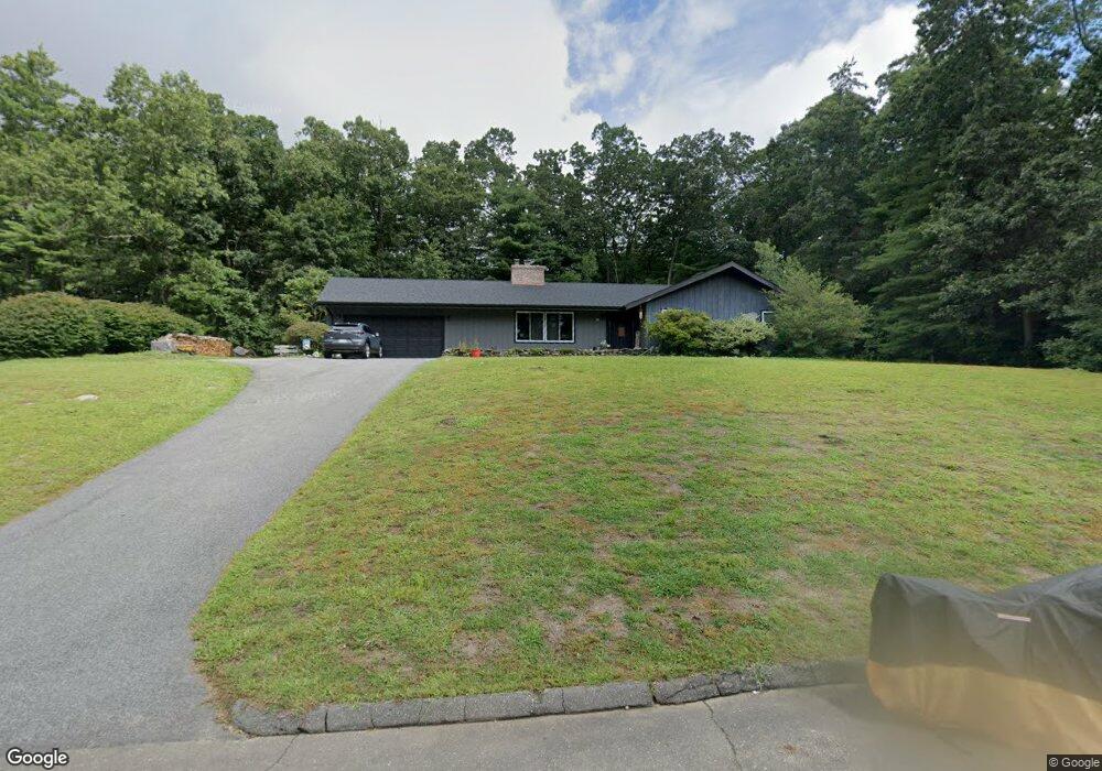
39 McDonald Cir Ludlow, MA 01056
Estimated Value: $423,000 - $490,000
3
Beds
2
Baths
1,778
Sq Ft
$259/Sq Ft
Est. Value
About This Home
This home is located at 39 McDonald Cir, Ludlow, MA 01056 and is currently estimated at $460,785, approximately $259 per square foot. 39 McDonald Cir is a home located in Hampden County with nearby schools including East Street Elementary School, Chapin Street Elementary School, and Paul R. Baird Middle School.
Ownership History
Date
Name
Owned For
Owner Type
Purchase Details
Closed on
Jul 20, 2018
Sold by
Ducharme Lynn and Lata Brian
Bought by
Germain Lynn and Germain Keith
Current Estimated Value
Purchase Details
Closed on
Sep 20, 2013
Sold by
Lata Chester T
Bought by
Ducharme Lynn and Lata Brian
Purchase Details
Closed on
Sep 3, 1998
Sold by
Longe Watson G and Longe Donna M
Bought by
Lata Agatha R
Create a Home Valuation Report for This Property
The Home Valuation Report is an in-depth analysis detailing your home's value as well as a comparison with similar homes in the area
Home Values in the Area
Average Home Value in this Area
Purchase History
| Date | Buyer | Sale Price | Title Company |
|---|---|---|---|
| Germain Lynn | -- | -- | |
| Germain Lynn | -- | -- | |
| Ducharme Lynn | -- | -- | |
| Ducharme Lynn | -- | -- | |
| Lata Agatha R | $156,000 | -- | |
| Lata Agatha R | $156,000 | -- |
Source: Public Records
Mortgage History
| Date | Status | Borrower | Loan Amount |
|---|---|---|---|
| Previous Owner | Lata Agatha R | $125,000 |
Source: Public Records
Tax History Compared to Growth
Tax History
| Year | Tax Paid | Tax Assessment Tax Assessment Total Assessment is a certain percentage of the fair market value that is determined by local assessors to be the total taxable value of land and additions on the property. | Land | Improvement |
|---|---|---|---|---|
| 2025 | $6,740 | $388,500 | $83,500 | $305,000 |
| 2024 | $6,364 | $351,800 | $83,500 | $268,300 |
| 2023 | $5,480 | $280,900 | $69,400 | $211,500 |
| 2022 | $5,217 | $261,000 | $69,400 | $191,600 |
| 2021 | $5,249 | $249,000 | $69,400 | $179,600 |
| 2020 | $5,081 | $246,400 | $68,400 | $178,000 |
| 2019 | $4,808 | $242,600 | $67,700 | $174,900 |
| 2018 | $4,532 | $238,400 | $67,700 | $170,700 |
| 2017 | $4,501 | $242,900 | $68,900 | $174,000 |
| 2016 | $4,534 | $250,100 | $79,500 | $170,600 |
| 2015 | $4,253 | $246,000 | $78,700 | $167,300 |
Source: Public Records
Map
Nearby Homes
- 319 Ventura St
- 22 Balsam Hill Rd
- 38 King Dr
- 88-90 Miller St
- 225 Maynard Rd
- 1172 East St
- 182 Mountain Rd
- 229 Miller St Unit F-13
- 229 Miller St Unit C-1
- 229 Miller St Unit B2
- 433 Ventura St
- 143 James St
- 2 Vista Rd
- 235 James St
- 299 Three Rivers Rd
- 308 Miller St Unit 72
- 308 Miller St Unit 79
- 308 Miller St Unit 78
- Lot 28 Tower Rd
- 6 Hawthorne Rd
- 25 McDonald Cir
- 59 McDonald Cir
- 166 Elizabeth Dr
- 68 McDonald Cir
- 58 McDonald Cir
- 155 Ventura St
- 185 Ventura St
- 149 Ventura St
- 187 Ventura St
- 145 Ventura St
- 199 Ventura St
- D Lot Ventura St
- 191 Ventura St
- 209211 Ventura St
- 189 Ventura St
- 139 Ventura St
- 209 Ventura St Unit 211
- 152 Elizabeth Dr
- 182 Elizabeth Dr
- 221 Ventura St