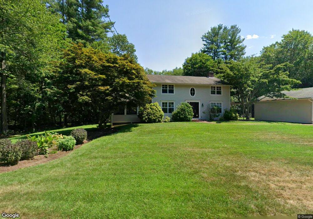
39 Meadowbrook Rd Carlisle, MA 01741
Estimated Value: $1,184,000 - $1,496,000
4
Beds
3
Baths
3,325
Sq Ft
$396/Sq Ft
Est. Value
About This Home
This home is located at 39 Meadowbrook Rd, Carlisle, MA 01741 and is currently estimated at $1,317,288, approximately $396 per square foot. 39 Meadowbrook Rd is a home located in Middlesex County with nearby schools including Carlisle School and Middlesex School.
Ownership History
Date
Name
Owned For
Owner Type
Purchase Details
Closed on
Mar 24, 2023
Sold by
Libby John
Bought by
J G Libby Tno 1 and Libby
Current Estimated Value
Purchase Details
Closed on
Mar 24, 2022
Sold by
Libby John
Bought by
J G Libby T 1
Purchase Details
Closed on
Dec 16, 2020
Sold by
Libby John and Libby Yvonne M
Bought by
Libby John
Purchase Details
Closed on
May 18, 1998
Sold by
Markley Cora Annette
Bought by
Libby John and Libby Yvonne
Home Financials for this Owner
Home Financials are based on the most recent Mortgage that was taken out on this home.
Original Mortgage
$260,000
Interest Rate
7.08%
Mortgage Type
Purchase Money Mortgage
Create a Home Valuation Report for This Property
The Home Valuation Report is an in-depth analysis detailing your home's value as well as a comparison with similar homes in the area
Home Values in the Area
Average Home Value in this Area
Purchase History
| Date | Buyer | Sale Price | Title Company |
|---|---|---|---|
| J G Libby Tno 1 | -- | None Available | |
| J G Libby T 1 | -- | None Available | |
| J G Libby T 1 | -- | None Available | |
| Libby John | -- | None Available | |
| Libby John | -- | None Available | |
| Libby John | -- | None Available | |
| Libby John | $325,000 | -- | |
| Libby John | $325,000 | -- | |
| Libby John | $325,000 | -- |
Source: Public Records
Mortgage History
| Date | Status | Borrower | Loan Amount |
|---|---|---|---|
| Previous Owner | Libby John | $200,000 | |
| Previous Owner | Libby John | $260,000 | |
| Previous Owner | Libby John | $109,044 |
Source: Public Records
Tax History Compared to Growth
Tax History
| Year | Tax Paid | Tax Assessment Tax Assessment Total Assessment is a certain percentage of the fair market value that is determined by local assessors to be the total taxable value of land and additions on the property. | Land | Improvement |
|---|---|---|---|---|
| 2025 | $14,104 | $1,070,100 | $566,400 | $503,700 |
| 2024 | $13,703 | $1,028,000 | $522,700 | $505,300 |
| 2023 | $13,195 | $932,500 | $500,900 | $431,600 |
| 2022 | $13,344 | $808,700 | $435,600 | $373,100 |
| 2021 | $13,166 | $808,700 | $435,600 | $373,100 |
| 2020 | $13,377 | $728,600 | $370,300 | $358,300 |
| 2019 | $13,163 | $719,700 | $370,300 | $349,400 |
| 2018 | $0 | $698,800 | $370,300 | $328,500 |
| 2017 | $0 | $693,000 | $370,300 | $322,700 |
| 2016 | $11,920 | $693,000 | $370,300 | $322,700 |
| 2015 | $10,836 | $570,300 | $352,800 | $217,500 |
| 2014 | $10,630 | $570,300 | $352,800 | $217,500 |
Source: Public Records
Map
Nearby Homes
- 225 Lowell St
- 8 Kay's Walk Unit 13
- 14 Kay's Walk
- 6 Kay's Walk Unit 6
- 6 Kay's Walk
- 2 Kay's Walk Unit 18
- 4 Kay's Walk Unit 15
- 3 Kay's Walk
- 15 Kay's Walk
- 1 Kay's Walk Unit 1
- 1 Kay's Walk
- 13 Kay's Walk
- 15 Kay's Walk Unit 4
- 3 Kay's Walk Unit 3
- 383 E Riding Dr
- 373 E Riding Dr
- 282 Brook St
- 232 Baldwin Rd
- 125 Maple St
- 1 Garrison Way Unit 1
- 5 Hillside Rd
- 43 Partridge Ln
- 31 Hillside Rd
- 103 Meadowbrook Rd
- 115 Partridge Ln
- 40 Hillside Rd
- 86 Partridge Ln
- 15 Partridge Ln
- 82 Hillside Rd
- 44 Partridge Ln
- 67 Hillside Rd
- 241 East St
- 133 Partridge Ln
- 305 East St
- 170 Lowell St
- 125 Meadowbrook Rd
- 208 Lowell St
- 190 Lowell St
- 164 Partridge Ln
- 288 Lowell St