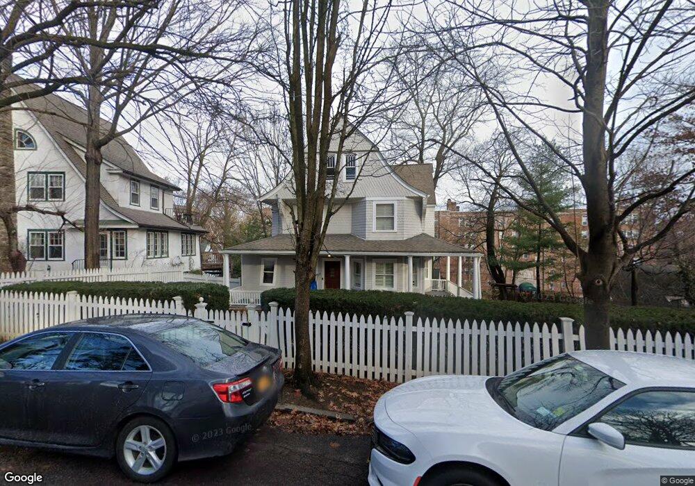
39 Merriam Ave Bronxville, NY 10708
Cedar Knolls NeighborhoodEstimated Value: $1,298,217 - $1,564,000
5
Beds
3
Baths
2,524
Sq Ft
$550/Sq Ft
Est. Value
About This Home
This home is located at 39 Merriam Ave, Bronxville, NY 10708 and is currently estimated at $1,388,054, approximately $549 per square foot. 39 Merriam Ave is a home located in Westchester County with nearby schools including St. Eugene School and Saint Joseph School.
Ownership History
Date
Name
Owned For
Owner Type
Purchase Details
Closed on
Jun 17, 2024
Sold by
Collins Kevin and Collins Rachael
Bought by
Obrien Kevin and Obrien Meredith
Current Estimated Value
Home Financials for this Owner
Home Financials are based on the most recent Mortgage that was taken out on this home.
Original Mortgage
$1,146,225
Interest Rate
6.86%
Mortgage Type
New Conventional
Purchase Details
Closed on
Sep 4, 1998
Sold by
Dallal Steven and Marziano Teresa
Bought by
Armstrong W David
Create a Home Valuation Report for This Property
The Home Valuation Report is an in-depth analysis detailing your home's value as well as a comparison with similar homes in the area
Home Values in the Area
Average Home Value in this Area
Purchase History
| Date | Buyer | Sale Price | Title Company |
|---|---|---|---|
| Obrien Kevin | $1,275,000 | First American Title | |
| Armstrong W David | $487,500 | Commonwealth Land Title Ins |
Source: Public Records
Mortgage History
| Date | Status | Borrower | Loan Amount |
|---|---|---|---|
| Previous Owner | Obrien Kevin | $1,146,225 |
Source: Public Records
Tax History Compared to Growth
Tax History
| Year | Tax Paid | Tax Assessment Tax Assessment Total Assessment is a certain percentage of the fair market value that is determined by local assessors to be the total taxable value of land and additions on the property. | Land | Improvement |
|---|---|---|---|---|
| 2024 | $2,815 | $15,800 | $5,800 | $10,000 |
| 2023 | $2,801 | $15,800 | $5,800 | $10,000 |
| 2022 | $2,782 | $15,800 | $5,800 | $10,000 |
| 2021 | $13,613 | $15,800 | $5,800 | $10,000 |
| 2020 | $13,615 | $15,800 | $5,800 | $10,000 |
| 2019 | $15,634 | $15,800 | $5,800 | $10,000 |
| 2018 | $13,136 | $15,800 | $5,800 | $10,000 |
| 2017 | -- | $15,800 | $5,800 | $10,000 |
| 2016 | $14,066 | $15,800 | $5,800 | $10,000 |
| 2015 | -- | $15,800 | $5,800 | $10,000 |
| 2014 | -- | $15,800 | $5,800 | $10,000 |
| 2013 | -- | $15,800 | $5,800 | $10,000 |
Source: Public Records
Map
Nearby Homes
- 270 Bronxville Rd Unit B63
- 270 Bronxville Rd Unit B43
- 280 Bronxville Rd Unit 5B
- 280 Bronxville Rd Unit 9B
- 250 Bronxville Rd Unit 2C
- 250 Bronxville Rd Unit 2G
- 1 Rivermere Unit 1G
- 45 Pondfield Rd W Unit 4C
- 45 Pondfield Rd W Unit 1F
- 25 Parkview Ave Unit 1I
- 25 Parkview Ave Unit 6L
- 25 Parkview Ave Unit 2G
- 25 Parkview Ave Unit 2K
- 25 Parkview Ave Unit 1K
- 35 Parkview Ave Unit 6K
- 35 Parkview Ave Unit 1C
- 35 Parkview Ave Unit 5C
- 35 Parkview Ave Unit 3F
- 35 Parkview Ave Unit 4J
- 56 Pondfield Rd W Unit 4A
- 41 Merriam Ave
- 47 Merriam Ave
- 271 Bronxville Rd
- 51 Merriam Ave
- 269 Bronxville Rd
- 25 Merriam Ave
- 279 Bronxville Rd
- 50 Merriam Ave
- 283 Bronxville Rd
- 31 Merriam Ave
- 33 Merriam Ave
- 55 Merriam Ave
- 265 Bronxville Rd
- 263 Bronxville Rd
- 287 Bronxville Rd
- 32 Merriam Ave
- 259 Bronxville Rd
- 270 Bronxville Rd Unit B83
- 270 Bronxville Rd Unit C
- 270 Bronxville Rd Unit A54