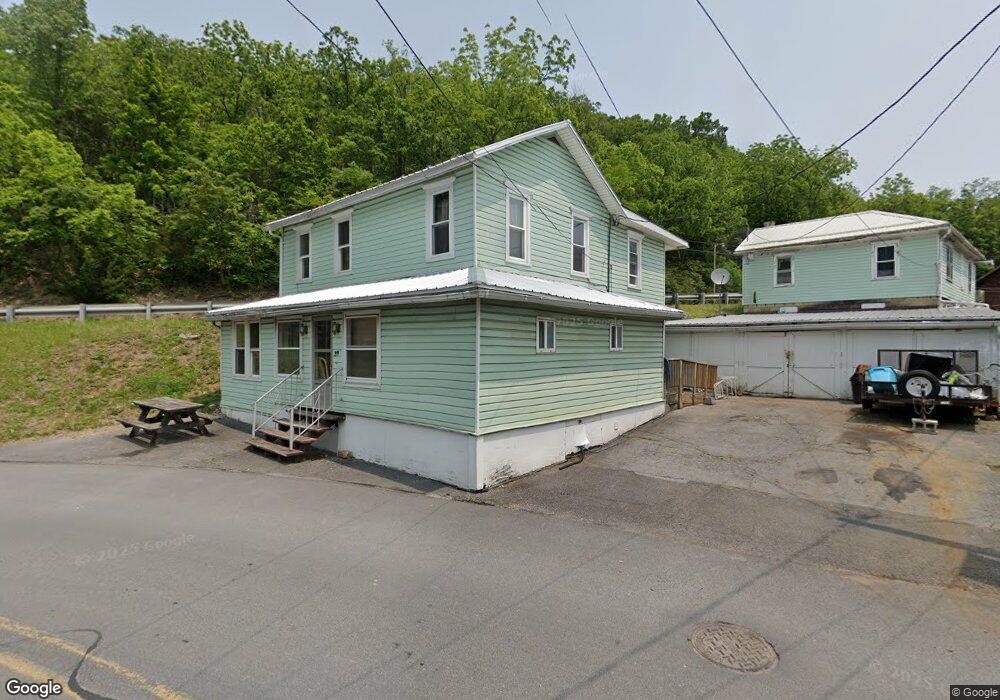
39 N Brown St Mc Clure, PA 17841
Estimated Value: $61,000 - $107,000
Studio
--
Bath
--
Sq Ft
6,970
Sq Ft Lot
About This Home
This home is located at 39 N Brown St, Mc Clure, PA 17841 and is currently estimated at $86,162. 39 N Brown St is a home located in Snyder County with nearby schools including Midd-West High School, Jacks Mountain School, and Bannerville School.
Ownership History
Date
Name
Owned For
Owner Type
Purchase Details
Closed on
Apr 19, 2017
Sold by
Young Jennifer N and Nelson Robert P
Bought by
Fitzgerald Keith and Kuhns Brandy
Current Estimated Value
Purchase Details
Closed on
Sep 19, 2005
Sold by
Auman Dallas E and Auman Pearl `
Bought by
Knepp Eugene and Knepp Ellen
Home Financials for this Owner
Home Financials are based on the most recent Mortgage that was taken out on this home.
Original Mortgage
$95,000
Interest Rate
6.34%
Mortgage Type
Purchase Money Mortgage
Create a Home Valuation Report for This Property
The Home Valuation Report is an in-depth analysis detailing your home's value as well as a comparison with similar homes in the area
Purchase History
| Date | Buyer | Sale Price | Title Company |
|---|---|---|---|
| Fitzgerald Keith | $10,000 | None Available | |
| Knepp Eugene | -- | -- |
Source: Public Records
Mortgage History
| Date | Status | Borrower | Loan Amount |
|---|---|---|---|
| Previous Owner | Knepp Eugene | $95,000 |
Source: Public Records
Tax History
| Year | Tax Paid | Tax Assessment Tax Assessment Total Assessment is a certain percentage of the fair market value that is determined by local assessors to be the total taxable value of land and additions on the property. | Land | Improvement |
|---|---|---|---|---|
| 2025 | $823 | $7,980 | $1,420 | $6,560 |
| 2024 | $773 | $7,980 | $1,420 | $6,560 |
| 2023 | $210 | $7,980 | $1,420 | $6,560 |
| 2022 | $769 | $7,980 | $1,420 | $6,560 |
| 2021 | $769 | $7,980 | $1,420 | $6,560 |
| 2020 | $769 | $7,980 | $1,420 | $6,560 |
| 2019 | $769 | $7,980 | $1,420 | $6,560 |
| 2018 | $769 | $7,980 | $1,420 | $6,560 |
| 2017 | $769 | $7,980 | $1,420 | $6,560 |
| 2016 | $238 | $7,980 | $1,420 | $6,560 |
| 2015 | $19,002 | $7,980 | $1,420 | $6,560 |
| 2014 | $19,002 | $7,980 | $1,420 | $6,560 |
Source: Public Records
Map
Nearby Homes
- 27 W Specht St
- 287 Pine Crest Dr
- Ridge Road Unit: 5 Lot
- Ridge Road Unit: 7 Lot
- Ridge Road Unit: 4 Lot
- Ridge Road Unit: 6 Lot
- 70 Kathryn Rd
- 2336 Snyder Avenue Unit: 2 Lot
- 2336 Snyder Avenue Unit: 3 Lot
- 2336 Snyder Avenue Unit: 1 Lot
- 0 Vanormer Rd Unit 2 PARCEL
- 0 Vanormer Rd Unit 1 PARCEL
- Vanormer Road Unit: 1 Parcel
- 0 Wagner Rd
- Vanormer Unit: 2 Parcel
- 6415 Us Hwy 522 N
- 4039 Route 235
- 435 Laurel Run Rd
- 20 Jack Pine Cir
- 62 Westfall St
- 0 U S 522
- Lot 1 U S 522
- 40 N Brown St
- 29 N Brown St Unit 31
- 27 N Brown St
- 28 N Brown St
- 21 N Brown St
- 21 N Brown St Unit 23
- 13 N Brown St
- 13 & 15 N Brown St
- 14 N Brown St
- 12 N Brown St
- 3 W Specht St
- 15 N Zellers St
- 3 E Specht St
- 9 E Specht St
- 25540 Route 522
- 10 N Brown St
- 5 W Specht St
- 10 E Specht St
Your Personal Tour Guide
Ask me questions while you tour the home.