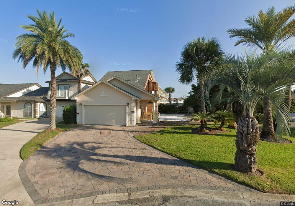
39 Port of Call Miramar Beach, FL 32550
Estimated Value: $690,015 - $796,000
3
Beds
3
Baths
1,823
Sq Ft
$413/Sq Ft
Est. Value
About This Home
This home is located at 39 Port of Call, Miramar Beach, FL 32550 and is currently estimated at $752,004, approximately $412 per square foot. 39 Port of Call is a home located in Walton County with nearby schools including Van R. Butler Elementary School, Emerald Coast Middle School, and South Walton High School.
Ownership History
Date
Name
Owned For
Owner Type
Purchase Details
Closed on
Sep 10, 2021
Sold by
Sulcer James R and Sulcer Karla
Bought by
Keefe Joseph and Keefe Marty J
Current Estimated Value
Purchase Details
Closed on
Feb 29, 2012
Sold by
Tilley Gregory P and Tilley Janna Kay
Bought by
Sulcer James R and Sulcer Karla
Home Financials for this Owner
Home Financials are based on the most recent Mortgage that was taken out on this home.
Original Mortgage
$300,000
Interest Rate
3.12%
Mortgage Type
Adjustable Rate Mortgage/ARM
Purchase Details
Closed on
Sep 27, 2002
Sold by
Lam Hung N and Nguyen Thuy Hoa
Bought by
Tilley Gregory P and Tilley Janna Kay
Create a Home Valuation Report for This Property
The Home Valuation Report is an in-depth analysis detailing your home's value as well as a comparison with similar homes in the area
Home Values in the Area
Average Home Value in this Area
Purchase History
| Date | Buyer | Sale Price | Title Company |
|---|---|---|---|
| Keefe Joseph | $550,000 | Mcneese Title Llc | |
| Sulcer James R | $375,000 | Attorney | |
| Tilley Gregory P | $200,000 | Security First Title Partner |
Source: Public Records
Mortgage History
| Date | Status | Borrower | Loan Amount |
|---|---|---|---|
| Previous Owner | Sulcer James R | $300,000 |
Source: Public Records
Tax History Compared to Growth
Tax History
| Year | Tax Paid | Tax Assessment Tax Assessment Total Assessment is a certain percentage of the fair market value that is determined by local assessors to be the total taxable value of land and additions on the property. | Land | Improvement |
|---|---|---|---|---|
| 2024 | $3,050 | $611,510 | $125,000 | $486,510 |
| 2023 | $3,050 | $335,694 | $109,145 | $226,549 |
| 2022 | $5,199 | $560,963 | $121,151 | $439,812 |
| 2021 | $4,120 | $433,226 | $105,965 | $327,261 |
| 2020 | $3,795 | $380,196 | $96,945 | $283,251 |
| 2019 | $3,665 | $371,451 | $93,216 | $278,235 |
| 2018 | $3,464 | $361,172 | $0 | $0 |
| 2017 | $3,228 | $347,196 | $87,020 | $260,176 |
| 2016 | $3,098 | $341,299 | $0 | $0 |
| 2015 | $2,545 | $250,345 | $0 | $0 |
| 2014 | $2,435 | $236,190 | $0 | $0 |
Source: Public Records
Map
Nearby Homes
- 60 Sandprints Dr Unit C12
- 60 Sandprints Dr Unit B3
- 60 Sandprints Dr Unit C4
- 60 Sandprints Dr Unit C6
- 91 Driftwood Rd
- 2312 Scenic Gulf Dr Unit 10A&B
- 11 Driftwood Rd Unit 2
- 11 Driftwood Rd Unit 22
- 11 Driftwood Rd Unit 9
- 2250 Scenic Gulf Dr Unit 101B (19)
- 2250 Scenic Gulf Dr Unit 105B
- 2250 Scenic Gulf Dr Unit 105B (23)
- 104 Ellis Rd Unit 4
- 241 Ellis Rd Unit 28
- 241 Ellis Rd Unit 24
- 241 Ellis Rd Unit 4
- 241 Ellis Rd Unit 33
- 212 Driftwood Rd
- 50 Surf Song Ln Unit 312D
- 50 Surf Song Ln Unit 409D
- 37 Port of Call
- 35 Port of Call
- 31 Port of Call
- 128 Newman Dr
- 140 Newman Dr
- 150 Newman Dr
- 116 Newman Dr
- 21 Port of Call
- 104 Newman Dr
- 160 Newman Dr
- 60 Sandprints Dr Unit A1
- 60 Sandprints Dr Unit D11
- 60 Sandprints Dr Unit B8
- 60 Sandprints Dr Unit B-4
- 60 Sandprints Dr Unit C2
- 60 Sandprints Dr Unit A11
- 60 Sandprints Dr Unit B11
- 60 Sandprints Dr Unit B1
- 60 Sandprints Dr Unit C9
- 60 Sandprints Dr Unit D4