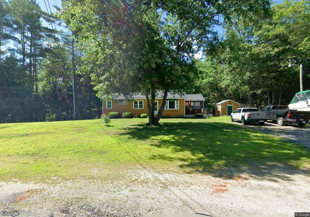
39 Staples Rd Turner, ME 04282
Estimated Value: $331,000 - $388,000
3
Beds
2
Baths
1,860
Sq Ft
$194/Sq Ft
Est. Value
About This Home
This home is located at 39 Staples Rd, Turner, ME 04282 and is currently estimated at $360,783, approximately $193 per square foot. 39 Staples Rd is a home located in Androscoggin County with nearby schools including Tripp Middle School, Leavitt Area High School, and Calvary Christian Academy.
Ownership History
Date
Name
Owned For
Owner Type
Purchase Details
Closed on
Jan 30, 2023
Sold by
Caito Terri L
Bought by
Caito Terri L and Ducharme Raymond R
Current Estimated Value
Purchase Details
Closed on
Jan 31, 2012
Sold by
Nadeau Paul L Est
Bought by
Caito Terri Lynn
Home Financials for this Owner
Home Financials are based on the most recent Mortgage that was taken out on this home.
Original Mortgage
$104,535
Interest Rate
3.94%
Mortgage Type
FHA
Purchase Details
Closed on
Jun 23, 2011
Sold by
Nadeau Doris L and Td Bank Na
Bought by
Bac Home Loans Svcng Lp
Create a Home Valuation Report for This Property
The Home Valuation Report is an in-depth analysis detailing your home's value as well as a comparison with similar homes in the area
Home Values in the Area
Average Home Value in this Area
Purchase History
| Date | Buyer | Sale Price | Title Company |
|---|---|---|---|
| Caito Terri L | -- | None Available | |
| Caito Terri Lynn | -- | -- | |
| Bac Home Loans Svcng Lp | -- | -- |
Source: Public Records
Mortgage History
| Date | Status | Borrower | Loan Amount |
|---|---|---|---|
| Previous Owner | Caito Terri Lynn | $104,535 |
Source: Public Records
Tax History
| Year | Tax Paid | Tax Assessment Tax Assessment Total Assessment is a certain percentage of the fair market value that is determined by local assessors to be the total taxable value of land and additions on the property. | Land | Improvement |
|---|---|---|---|---|
| 2025 | $2,613 | $192,100 | $54,500 | $137,600 |
| 2024 | $2,449 | $192,100 | $54,500 | $137,600 |
| 2023 | $2,411 | $192,100 | $54,500 | $137,600 |
| 2022 | $2,190 | $192,100 | $54,500 | $137,600 |
| 2021 | $2,190 | $192,100 | $54,500 | $137,600 |
| 2020 | $2,139 | $119,500 | $34,000 | $85,500 |
| 2019 | $5,014 | $119,500 | $34,000 | $85,500 |
| 2018 | $5,014 | $119,500 | $34,000 | $85,500 |
| 2016 | $4,817 | $119,500 | $34,000 | $85,500 |
| 2015 | $1,900 | $119,500 | $34,000 | $85,500 |
| 2014 | $1,876 | $119,500 | $34,000 | $85,500 |
| 2013 | $1,790 | $119,500 | $34,000 | $85,500 |
Source: Public Records
Map
Nearby Homes
- 50 Magnum Dr
- 0 Auburn Rd Unit 1648743
- 28-1 Auburn Rd
- Lot 21 Auburn Rd
- 33-028 Auburn Rd
- 00000 Auburn Rd
- 51 School House Hill Rd
- 15 Seaward Rd
- 23 Shire Ln
- 14 Shire
- 440 Mountainside Dr
- 562 Lower St
- 78 Sunset Blvd
- 60 Back Bryant Rd
- 5 Deer Run
- 17 Aspen Way
- 42 Center Bridge Rd
- 8-3 Turner St
- 34 Scenic View Dr
- 24 Conejo Ln
- 35 Staples Rd
- 45 Staples Rd
- 50 Staples Rd
- 30 Staples Rd
- 0 Staples Road Lot 2
- 0 Staples Road Lot 1
- 29 Staples Rd
- 170 Buckfield Rd
- 186 Buckfield Rd
- 21 Staples Rd
- 181 Buckfield Rd
- 67 Staples Rd
- 163 Buckfield Rd
- 0 Staples Rd
- 40 Mancine Rd
- 126 Buckfield Rd
- 17 Mancine Rd
- 41 Mancine Rd
- 0 Route 117 Lot 8 Unit 869067
- 68 Rte 117
Your Personal Tour Guide
Ask me questions while you tour the home.