
Landlord's Agent in 2025
Rosania Melo
Century 21 Scala Group
(203) 545-1459
38 in this area
193 Total Sales
Estimated Value: $466,000 - $570,000
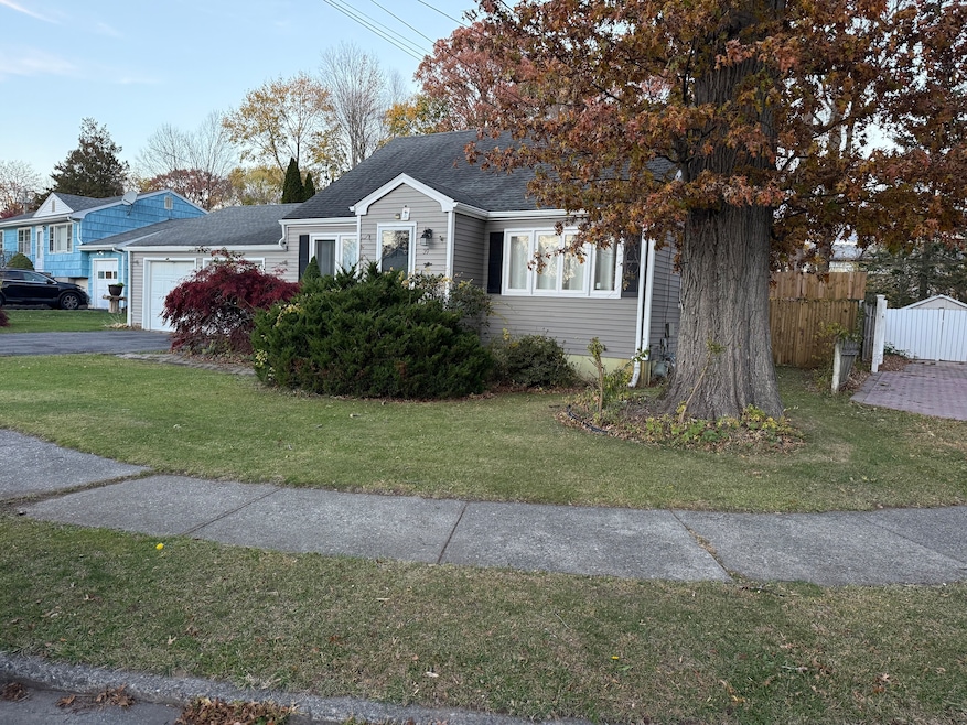
Spacious single-family home for rent in the desirable North End of Bridgeport! This well-maintained property features 4 bedrooms and 2 full bathrooms, a bright living room, formal dining room, and convenient main-floor laundry. Enjoy a large fenced backyard-perfect for outdoor gatherings-and a 2-car garage for plenty of parking and storage. Excellent location close to Sacred Heart University, Trumbull Mall, local shops, restaurants, and major highways. Don't miss this great rental opportunity in a prime neighborhood!
Last Agent to Rent the Property
Century 21 Scala Group Brokerage Phone: (203) 545-1459 License #RES.0810132 Listed on: 11/06/2025
Last Renter's Agent
Century 21 Scala Group Brokerage Phone: (203) 545-1459 License #RES.0810132 Listed on: 11/06/2025
| Date | Buyer | Sale Price | Title Company |
|---|---|---|---|
| Teixeira Rodrigo | -- | None Available | |
| Teixeira Rodrigo | -- | None Available | |
| Teixeira Rodrigo | -- | None Available | |
| Teixeira Gisele | $290,000 | -- | |
| Quananta Carol | $230,000 | -- | |
| Carbone Robert | $153,000 | -- | |
| Teixeira Gisele | $290,000 | -- | |
| Quananta Carol | $230,000 | -- | |
| Carbone Robert | $153,000 | -- | |
| Janda John | $205,000 | -- |
| Date | Status | Borrower | Loan Amount |
|---|---|---|---|
| Previous Owner | Janda John | $306,000 | |
| Previous Owner | Janda John | $275,500 |
| Date | Event | Price | List to Sale | Price per Sq Ft |
|---|---|---|---|---|
| 11/20/2025 11/20/25 | Rented | $3,100 | -11.4% | -- |
| 11/12/2025 11/12/25 | Under Contract | -- | -- | -- |
| 11/06/2025 11/06/25 | For Rent | $3,500 | -- | -- |
| Year | Tax Paid | Tax Assessment Tax Assessment Total Assessment is a certain percentage of the fair market value that is determined by local assessors to be the total taxable value of land and additions on the property. | Land | Improvement |
|---|---|---|---|---|
| 2025 | $7,956 | $183,110 | $76,850 | $106,260 |
| 2024 | $7,956 | $183,110 | $76,850 | $106,260 |
| 2023 | $7,956 | $183,110 | $76,850 | $106,260 |
| 2022 | $7,956 | $183,110 | $76,850 | $106,260 |
| 2021 | $7,956 | $183,110 | $76,850 | $106,260 |
| 2020 | $7,895 | $146,240 | $60,200 | $86,040 |
| 2019 | $7,895 | $146,240 | $60,200 | $86,040 |
| 2018 | $7,951 | $146,240 | $60,200 | $86,040 |
| 2017 | $7,951 | $146,240 | $60,200 | $86,040 |
| 2016 | $7,951 | $146,240 | $60,200 | $86,040 |
| 2015 | $7,200 | $170,620 | $59,230 | $111,390 |
| 2014 | $7,200 | $170,620 | $59,230 | $111,390 |
Landlord's Agent in 2025
Rosania Melo
Century 21 Scala Group
(203) 545-1459
38 in this area
193 Total Sales
Source: SmartMLS
MLS Number: 24138777
APN: BRID-002513-000025
Disclaimer: Certain information contained herein is derived from information provided by parties other than Homes.com. All information provided is deemed reliable, but is not guaranteed to be accurate and should be independently verified.
![]() IDX information is provided exclusively for personal, non-commercial use, and may not be used for any purpose other than to identify prospective properties consumers may be interested in purchasing. Information is deemed reliable but not guaranteed.
IDX information is provided exclusively for personal, non-commercial use, and may not be used for any purpose other than to identify prospective properties consumers may be interested in purchasing. Information is deemed reliable but not guaranteed.