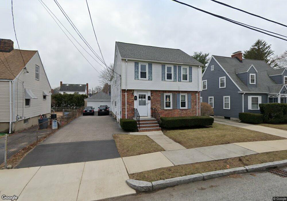
39 Tufts St Arlington, MA 02474
East Arlington NeighborhoodEstimated Value: $1,324,000 - $1,852,428
4
Beds
3
Baths
3,460
Sq Ft
$443/Sq Ft
Est. Value
About This Home
This home is located at 39 Tufts St, Arlington, MA 02474 and is currently estimated at $1,532,857, approximately $443 per square foot. 39 Tufts St is a home located in Middlesex County with nearby schools including Thompson School, Hardy Elementary School, and Ottoson Middle School.
Ownership History
Date
Name
Owned For
Owner Type
Purchase Details
Closed on
Apr 21, 2025
Sold by
Michael R Heath Supplemen R and Michael Heath
Bought by
Ring My Bell Llc and Heath
Current Estimated Value
Purchase Details
Closed on
Jan 31, 2011
Sold by
Heath Zachary and Heath Bruce Ohanian
Bought by
Arlington Town Of
Purchase Details
Closed on
Feb 2, 2010
Sold by
Heath Donn R and Heath Veronica J
Bought by
Heath Zachary and Heath Bruce Ohanian
Create a Home Valuation Report for This Property
The Home Valuation Report is an in-depth analysis detailing your home's value as well as a comparison with similar homes in the area
Home Values in the Area
Average Home Value in this Area
Purchase History
| Date | Buyer | Sale Price | Title Company |
|---|---|---|---|
| Ring My Bell Llc | -- | None Available | |
| Arlington Town Of | -- | -- | |
| Arlington Town Of | -- | -- | |
| Heath Zachary | $517,000 | -- | |
| Heath Zachary | $517,000 | -- |
Source: Public Records
Mortgage History
| Date | Status | Borrower | Loan Amount |
|---|---|---|---|
| Previous Owner | Heath Zachary | $17,000 |
Source: Public Records
Tax History
| Year | Tax Paid | Tax Assessment Tax Assessment Total Assessment is a certain percentage of the fair market value that is determined by local assessors to be the total taxable value of land and additions on the property. | Land | Improvement |
|---|---|---|---|---|
| 2025 | $15,636 | $1,451,800 | $592,800 | $859,000 |
| 2024 | $10,664 | $1,007,000 | $564,300 | $442,700 |
| 2023 | $10,628 | $948,100 | $473,100 | $475,000 |
| 2022 | $10,584 | $926,800 | $456,000 | $470,800 |
| 2021 | $10,270 | $905,600 | $456,000 | $449,600 |
| 2020 | $10,017 | $905,700 | $456,000 | $449,700 |
| 2019 | $9,367 | $831,900 | $484,500 | $347,400 |
| 2018 | $8,501 | $700,800 | $353,400 | $347,400 |
| 2017 | $7,959 | $633,700 | $307,800 | $325,900 |
| 2016 | $7,528 | $588,100 | $262,200 | $325,900 |
| 2015 | $7,415 | $547,200 | $256,500 | $290,700 |
Source: Public Records
Map
Nearby Homes
- 61-63 Foster St
- 454-460 Massachusetts Ave
- 52 Warren St
- 120 Broadway
- 53 Warren St Unit 53
- 30 Elmhurst Rd
- 27-29 Dartmouth St Unit 1
- 89 Cleveland St Unit 89
- 18 Wellesley Rd
- 199 Everett St Unit 199
- 15 Medford St Unit 4
- 155-157 Palmer St
- 6 Gordon Rd
- 45 Teel St
- 29 Mott St Unit 29
- 68-70 Hamlet St
- 165-167 Franklin St Unit 1
- 145 Jerome St
- 35 Boulevard Rd Unit 37
- 327 Alewife Brook Pkwy Unit A
Your Personal Tour Guide
Ask me questions while you tour the home.