
C
Seller's Agent in 2025
Chase Caprio
Maine Real Estate Experts
(207) 653-5023
13 in this area
29 Total Sales

Estimated Value: $485,000 - $492,000
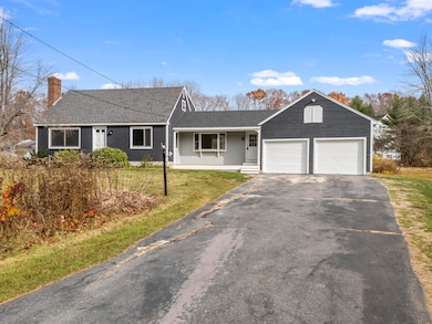
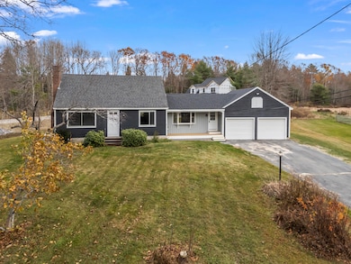
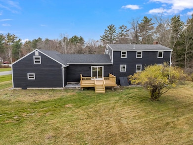
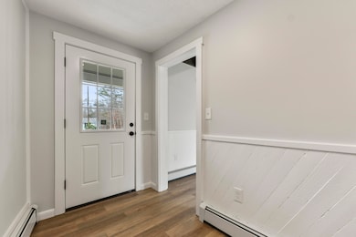
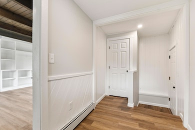
Welcome to this freshly updated Cape-style home conveniently located in Windham. Step inside to find a bright and modern interior featuring a brand-new kitchen with stainless steel appliances, quartz countertops, and updated cabinetry — perfect for cooking and entertaining. This spacious home offers four bedrooms and one and a half baths, providing flexibility for families, guests, or a home office. The flowing layout combines charm and functionality with fresh finishes throughout. Move-in ready and beautifully refreshed, this home is ready for its next chapter. Don't miss your chance to make it yours!
| Date | Buyer | Sale Price | Title Company |
|---|---|---|---|
| Sullivan Brittany A | $490,000 | -- | |
| Ccre | -- | -- | |
| Ccre | -- | -- | |
| Ccre | -- | -- | |
| Ccre | -- | -- | |
| Ccre | -- | -- | |
| Ccre | -- | -- | |
| Ccre | $400,000 | None Available | |
| Ccre | $400,000 | None Available | |
| Morgan Tracy L | -- | None Available | |
| Morgan Tracy L | -- | None Available | |
| Morgan Ft | -- | None Available | |
| Morgan Ft | -- | None Available | |
| Morgan Peter B | -- | None Available | |
| Morgan Peter B | -- | None Available |
| Date | Status | Borrower | Loan Amount |
|---|---|---|---|
| Open | Sullivan Brittany A | $392,000 |
| Date | Event | Price | List to Sale | Price per Sq Ft |
|---|---|---|---|---|
| 12/17/2025 12/17/25 | Sold | $490,000 | -2.0% | $298 / Sq Ft |
| 11/16/2025 11/16/25 | Pending | -- | -- | -- |
| 11/10/2025 11/10/25 | For Sale | $499,900 | -- | $304 / Sq Ft |
| Year | Tax Paid | Tax Assessment Tax Assessment Total Assessment is a certain percentage of the fair market value that is determined by local assessors to be the total taxable value of land and additions on the property. | Land | Improvement |
|---|---|---|---|---|
| 2025 | $5,282 | $438,000 | $143,600 | $294,400 |
| 2024 | $4,954 | $431,900 | $137,500 | $294,400 |
| 2023 | $4,585 | $409,400 | $127,900 | $281,500 |
| 2022 | $4,223 | $363,700 | $113,300 | $250,400 |
| 2021 | $3,774 | $299,500 | $98,700 | $200,800 |
| 2020 | $3,872 | $258,100 | $86,900 | $171,200 |
| 2019 | $3,779 | $258,100 | $86,900 | $171,200 |
| 2018 | $3,481 | $229,300 | $78,100 | $151,200 |
| 2017 | $3,419 | $208,100 | $70,000 | $138,100 |
| 2016 | $3,204 | $204,100 | $70,000 | $134,100 |
| 2015 | $3,092 | $204,100 | $70,000 | $134,100 |
| 2014 | $2,847 | $204,100 | $70,000 | $134,100 |
| 2013 | -- | $204,100 | $70,000 | $134,100 |
C
Seller's Agent in 2025
Chase Caprio
Maine Real Estate Experts
(207) 653-5023
13 in this area
29 Total Sales
K
Buyer's Agent in 2025
Katie Hatch
RE/MAX
(207) 553-7500
1 in this area
19 Total Sales
Source: Maine Listings
MLS Number: 1643161
APN: WINM-000015C-000025-A000000
Disclaimer: Certain information contained herein is derived from information provided by parties other than Homes.com. All information provided is deemed reliable, but is not guaranteed to be accurate and should be independently verified.
![]() Listing data is derived in whole or in part from Maine Real Estate Information System, Inc. (d/b/a Maine Listings) and is for consumers' personal, noncommercial use only. Dimensions are approximate and not guaranteed. All data should be independently verified.
Listing data is derived in whole or in part from Maine Real Estate Information System, Inc. (d/b/a Maine Listings) and is for consumers' personal, noncommercial use only. Dimensions are approximate and not guaranteed. All data should be independently verified.
© 2026 Maine Real Estate Information System, Inc. All Rights Reserved. Equal Housing Opportunity.
Homes.com, LLC, 17600 Laguna Canyon Rd Irvine, CA 92618 (888)-952-6393
![]()
Ask me questions while you tour the home.