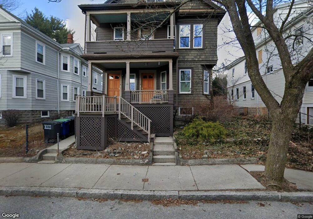
39 Whitfield Rd Somerville, MA 02144
West Somerville NeighborhoodEstimated Value: $1,167,000 - $1,724,886
5
Beds
2
Baths
2,300
Sq Ft
$604/Sq Ft
Est. Value
About This Home
This home is located at 39 Whitfield Rd, Somerville, MA 02144 and is currently estimated at $1,389,722, approximately $604 per square foot. 39 Whitfield Rd is a home located in Middlesex County with nearby schools including Somerville High School, St. Clement Elementary School, and International School of Boston.
Ownership History
Date
Name
Owned For
Owner Type
Purchase Details
Closed on
Sep 1, 2011
Sold by
Roberts John D and Roberts Laurelyn
Bought by
Mcdonagh Anthony T
Current Estimated Value
Home Financials for this Owner
Home Financials are based on the most recent Mortgage that was taken out on this home.
Original Mortgage
$437,000
Outstanding Balance
$309,617
Interest Rate
5%
Mortgage Type
Purchase Money Mortgage
Estimated Equity
$1,080,105
Create a Home Valuation Report for This Property
The Home Valuation Report is an in-depth analysis detailing your home's value as well as a comparison with similar homes in the area
Home Values in the Area
Average Home Value in this Area
Purchase History
| Date | Buyer | Sale Price | Title Company |
|---|---|---|---|
| Mcdonagh Anthony T | $620,000 | -- |
Source: Public Records
Mortgage History
| Date | Status | Borrower | Loan Amount |
|---|---|---|---|
| Open | Mcdonagh Anthony T | $437,000 |
Source: Public Records
Tax History
| Year | Tax Paid | Tax Assessment Tax Assessment Total Assessment is a certain percentage of the fair market value that is determined by local assessors to be the total taxable value of land and additions on the property. | Land | Improvement |
|---|---|---|---|---|
| 2025 | $13,105 | $1,201,200 | $704,200 | $497,000 |
| 2024 | $12,361 | $1,175,000 | $704,200 | $470,800 |
| 2023 | $12,067 | $1,167,000 | $704,200 | $462,800 |
| 2022 | $11,139 | $1,094,200 | $670,600 | $423,600 |
| 2021 | $10,861 | $1,065,800 | $665,700 | $400,100 |
| 2020 | $10,679 | $1,058,400 | $666,200 | $392,200 |
| 2019 | $10,042 | $933,300 | $606,400 | $326,900 |
| 2018 | $9,707 | $858,300 | $551,300 | $307,000 |
| 2017 | $9,348 | $801,000 | $520,200 | $280,800 |
| 2016 | $9,535 | $761,000 | $464,500 | $296,500 |
| 2015 | $9,083 | $720,300 | $429,000 | $291,300 |
Source: Public Records
Map
Nearby Homes
- 202 Powder House Blvd Unit 2
- 7 Whitman St Unit 1
- 1004 Broadway Unit 3
- 90 Conwell Ave
- 23 College Hill Rd Unit 1
- 30 Clarendon Ave
- 14 Farragut Ave Unit 1
- 16 Claremon St
- 33 Newbury St Unit 1
- 18 Paulina St Unit 1
- 138 North St
- 20 Cameron Ave
- 150 North St Unit 150
- 111 Pearson Rd
- 1328 Broadway Unit 3
- 11 Sterling St
- 34 Quincy St Unit 1
- 27 Gorham St
- 59A High St Unit A
- 5 Glendale Ave Unit 5
- 35 Whitfield Rd
- 35 Whitfield Rd Unit 3
- 43 Whitfield Rd
- 31 Whitfield Rd
- 33 Whitfield Rd
- 40 Whitfield Rd Unit 1
- 40 Whitfield Rd
- 42 Whitfield Rd
- 42 Whitfield Rd Unit 2
- 42 Whitfield Rd Unit 42
- 42 Whitfield Rd
- 42 Whitfield Rd Unit 1
- 97 Curtis St
- 46 Whitfield Rd
- 38 Whitfield Rd
- 27 Whitfield Rd
- 50 Whitfield Rd
- 50 Whitfield Rd Unit 1
- 48 Whitfield Rd Unit 1
- 48 Whitfield Rd Unit 48
Your Personal Tour Guide
Ask me questions while you tour the home.