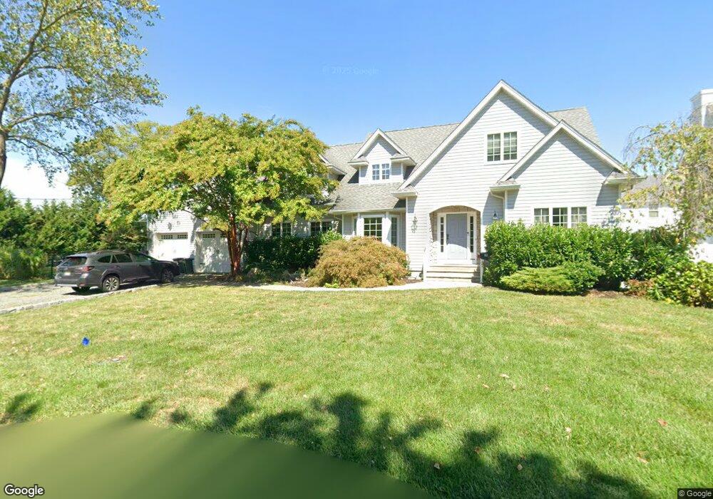
39 Wyandotte Ave Oceanport, NJ 07757
Estimated Value: $1,451,000 - $1,711,000
4
Beds
3
Baths
3,297
Sq Ft
$472/Sq Ft
Est. Value
About This Home
This home is located at 39 Wyandotte Ave, Oceanport, NJ 07757 and is currently estimated at $1,557,511, approximately $472 per square foot. 39 Wyandotte Ave is a home located in Monmouth County with nearby schools including Wolf Hill Elementary School, Maple Place Elementary and Middle School, and Shore Regional High School.
Ownership History
Date
Name
Owned For
Owner Type
Purchase Details
Closed on
Nov 30, 2007
Sold by
Kripaitis Jacqueline
Bought by
Kripaitis Jacqueline
Current Estimated Value
Purchase Details
Closed on
Oct 19, 2000
Sold by
Attardi James
Bought by
Kripaitis Jacqueline
Purchase Details
Closed on
Jul 10, 1998
Sold by
Thomas Nicholas
Bought by
Attardi Vencenza
Purchase Details
Closed on
Sep 17, 1997
Sold by
Pisano Thomas
Bought by
Nichols Thomas
Create a Home Valuation Report for This Property
The Home Valuation Report is an in-depth analysis detailing your home's value as well as a comparison with similar homes in the area
Home Values in the Area
Average Home Value in this Area
Purchase History
| Date | Buyer | Sale Price | Title Company |
|---|---|---|---|
| Kripaitis Jacqueline | -- | None Available | |
| Kripaitis Jacqueline | $429,900 | -- | |
| Attardi Vencenza | $92,000 | -- | |
| Nichols Thomas | $67,000 | -- |
Source: Public Records
Tax History Compared to Growth
Tax History
| Year | Tax Paid | Tax Assessment Tax Assessment Total Assessment is a certain percentage of the fair market value that is determined by local assessors to be the total taxable value of land and additions on the property. | Land | Improvement |
|---|---|---|---|---|
| 2025 | $17,014 | $1,231,300 | $575,800 | $655,500 |
| 2024 | $16,743 | $1,077,500 | $450,500 | $627,000 |
| 2023 | $16,743 | $1,006,200 | $410,500 | $595,700 |
| 2022 | $16,991 | $904,900 | $380,500 | $524,400 |
| 2021 | $16,991 | $891,900 | $365,500 | $526,400 |
| 2020 | $15,774 | $862,900 | $345,500 | $517,400 |
| 2019 | $15,164 | $842,000 | $335,500 | $506,500 |
| 2018 | $15,058 | $841,700 | $335,500 | $506,200 |
| 2017 | $15,748 | $730,100 | $216,500 | $513,600 |
| 2016 | $15,460 | $721,400 | $217,500 | $503,900 |
| 2015 | $14,589 | $703,400 | $212,500 | $490,900 |
| 2014 | $14,276 | $698,100 | $262,500 | $435,600 |
Source: Public Records
Map
Nearby Homes
- 8 Pocahontas Ave
- 15 Signal Ave
- 580 Patten Ave Unit 48
- 580 Patten Ave Unit 62
- 580 Patten Ave Unit 86
- 580 Patten Ave Unit 31
- 66 Shrewsbury Ave
- 28 Patten Ln
- 3 Foggia Way
- 16 Shore Dr
- 165 Kingsley St
- 13 Morris Place
- 164 Airsdale Ave
- 15 Airsdale Ave
- 392 Florence Ave
- 10 Asbury Ave
- 8 Mann Ct
- 154 Atlantic Ave
- 323 Florence Ave
- 7 Manahassett Park Dr
- 35 Wyandotte Ave
- 38 Wyandotte Ave
- 47 Wyandotte Ave
- 34 Wyandotte Ave
- 42 Pocahontas Ave
- 42 Wyandotte Ave
- 29 Wyandotte Ave
- 43 Algonquin Ave
- 39 Pocahontas Ave
- 28 Pocahontas Ave
- 33 Pocahontas Ave
- 39 Algonquin Ave
- 30 Wyandotte Ave
- 47 Algonquin Ave
- 49 Wyandotte Ave
- 445 Port Au Peck Ave
- 43 Pocahontas Ave
- 27 Pocahontas Ave
- 50 Wyandotte Ave
- 35 Algonquin Ave