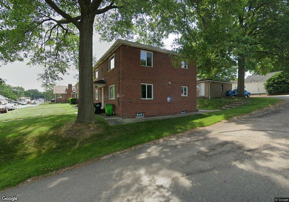
390 E Huston St Unit 392 Barberton, OH 44203
East Barberton NeighborhoodEstimated Value: $156,000 - $211,352
4
Beds
2
Baths
2,106
Sq Ft
$83/Sq Ft
Est. Value
About This Home
This home is located at 390 E Huston St Unit 392, Barberton, OH 44203 and is currently estimated at $175,088, approximately $83 per square foot. 390 E Huston St Unit 392 is a home located in Summit County with nearby schools including Barberton Intermediate School 3-5, Barberton Middle School, and Barberton High School.
Ownership History
Date
Name
Owned For
Owner Type
Purchase Details
Closed on
Aug 17, 2011
Sold by
Fannie Mae
Bought by
West 2006 Ltd
Current Estimated Value
Purchase Details
Closed on
Apr 15, 2011
Sold by
Fannie Mae
Bought by
West 2006 Ltd
Purchase Details
Closed on
Jun 23, 2010
Sold by
Vincent David W and Vincent Colleen E
Bought by
Federal National Mortgage Association
Purchase Details
Closed on
Apr 10, 2001
Sold by
Mahler Herbert A
Bought by
Vincent David W and Vincent Collen E
Home Financials for this Owner
Home Financials are based on the most recent Mortgage that was taken out on this home.
Original Mortgage
$72,000
Interest Rate
7.03%
Mortgage Type
Purchase Money Mortgage
Create a Home Valuation Report for This Property
The Home Valuation Report is an in-depth analysis detailing your home's value as well as a comparison with similar homes in the area
Home Values in the Area
Average Home Value in this Area
Purchase History
| Date | Buyer | Sale Price | Title Company |
|---|---|---|---|
| West 2006 Ltd | $41,475 | Ohio Title Corp | |
| West 2006 Ltd | $44,100 | Ohio Title Corp | |
| Federal National Mortgage Association | $88,163 | Ohio Title Corp | |
| Vincent David W | $90,000 | Buckeye Reserve Title Agency |
Source: Public Records
Mortgage History
| Date | Status | Borrower | Loan Amount |
|---|---|---|---|
| Previous Owner | Vincent David W | $72,000 |
Source: Public Records
Tax History Compared to Growth
Tax History
| Year | Tax Paid | Tax Assessment Tax Assessment Total Assessment is a certain percentage of the fair market value that is determined by local assessors to be the total taxable value of land and additions on the property. | Land | Improvement |
|---|---|---|---|---|
| 2025 | $2,773 | $54,005 | $9,730 | $44,275 |
| 2024 | $2,773 | $54,005 | $9,730 | $44,275 |
| 2023 | $2,773 | $54,005 | $9,730 | $44,275 |
| 2022 | $2,204 | $37,241 | $6,619 | $30,622 |
| 2021 | $2,202 | $37,241 | $6,619 | $30,622 |
| 2020 | $2,156 | $37,240 | $6,620 | $30,620 |
| 2019 | $1,745 | $27,300 | $6,500 | $20,800 |
| 2018 | $1,719 | $27,300 | $6,500 | $20,800 |
| 2017 | $1,741 | $27,300 | $6,500 | $20,800 |
| 2016 | $1,745 | $27,300 | $6,500 | $20,800 |
| 2015 | $1,741 | $27,300 | $6,500 | $20,800 |
| 2014 | $1,733 | $27,300 | $6,500 | $20,800 |
| 2013 | $2,003 | $32,730 | $6,500 | $26,230 |
Source: Public Records
Map
Nearby Homes
- 357 E Paige Ave
- 320 Lincoln Ave Unit 322
- 412 Grandview Ave
- 334 E Tuscarawas Ave
- 414 E Baird Ave
- 613 Wooster Rd N
- 46 Brown St
- 0 Wooster Rd N
- 653 Washington Ave
- 327 Robinson Ave
- 442 Wooster Rd N
- 477 Robinson Ave
- 261 E State St
- 650 E Tuscarawas Ave
- 44 W Summit St
- 25 S Van Buren Ave
- 43 S Van Buren Ave
- 645 Madison Ave
- 690 Saint Clair Ave
- 251 Slate Ridge Dr
- 394 E Huston St Unit 396
- 394 396 E Huston St
- 398 E Huston St Unit 400
- 376 E Huston St
- 389 E Hopocan Ave
- 404 E Huston St
- 393 E Hopocan Ave
- 399 E Hopocan Ave
- 379 E Hopocan Ave
- 393 E Huston St
- 408 E Huston St
- 397 E Huston St
- 405 E Hopocan Ave
- 370 E Huston St
- 405 E Huston St
- 373 E Hopocan Ave
- 375 E Huston St
- 414 E Huston St
- 409 E Hopocan Ave
- 375 E Hopocan Ave