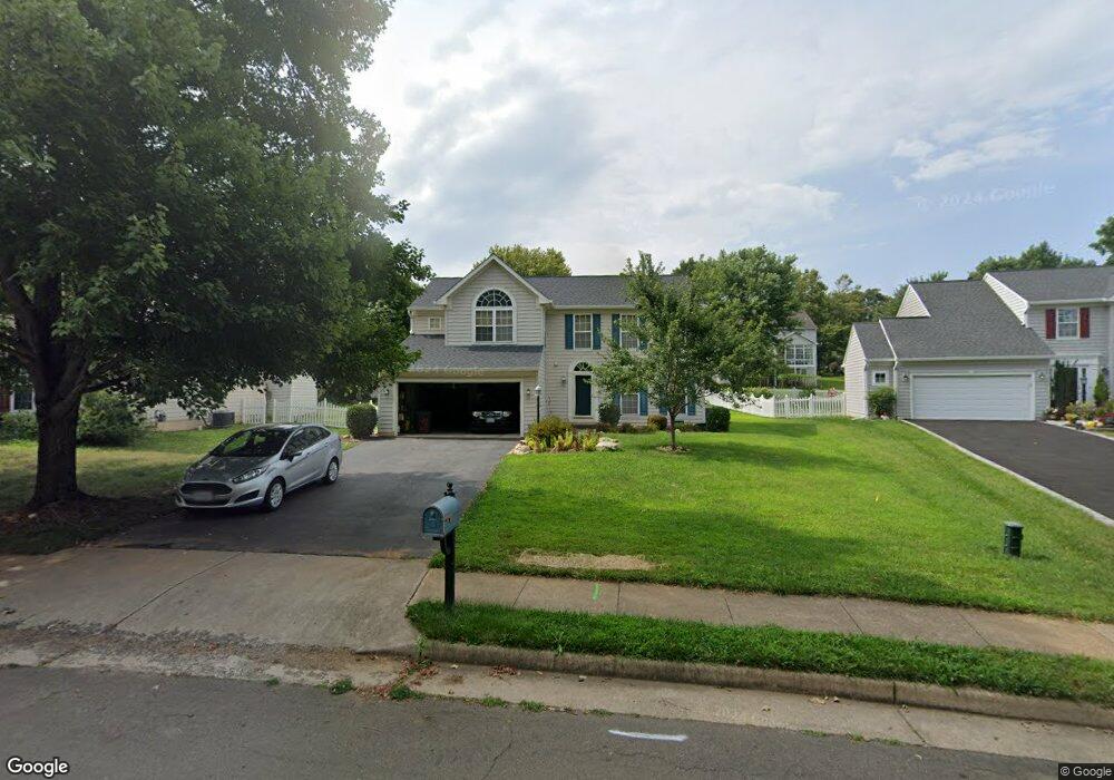
390 Singleton Cir Warrenton, VA 20186
Estimated Value: $618,000 - $758,000
3
Beds
4
Baths
2,508
Sq Ft
$275/Sq Ft
Est. Value
About This Home
This home is located at 390 Singleton Cir, Warrenton, VA 20186 and is currently estimated at $688,501, approximately $274 per square foot. 390 Singleton Cir is a home located in Fauquier County with nearby schools including James G. Brumfield Elementary School, W.C. Taylor Middle School, and Fauquier High School.
Ownership History
Date
Name
Owned For
Owner Type
Purchase Details
Closed on
Aug 22, 2013
Sold by
Mcdaniel Gregory E and Mcdaniel Dawn S
Bought by
Mcdaniel Dawn S
Current Estimated Value
Purchase Details
Closed on
Jul 11, 2002
Sold by
N V R Inc
Bought by
Mcdaniel Gregory E
Home Financials for this Owner
Home Financials are based on the most recent Mortgage that was taken out on this home.
Original Mortgage
$206,050
Interest Rate
6.79%
Create a Home Valuation Report for This Property
The Home Valuation Report is an in-depth analysis detailing your home's value as well as a comparison with similar homes in the area
Home Values in the Area
Average Home Value in this Area
Purchase History
| Date | Buyer | Sale Price | Title Company |
|---|---|---|---|
| Mcdaniel Dawn S | -- | -- | |
| Mcdaniel Gregory E | $257,595 | -- |
Source: Public Records
Mortgage History
| Date | Status | Borrower | Loan Amount |
|---|---|---|---|
| Previous Owner | Mcdaniel Gregory E | $206,050 |
Source: Public Records
Tax History
| Year | Tax Paid | Tax Assessment Tax Assessment Total Assessment is a certain percentage of the fair market value that is determined by local assessors to be the total taxable value of land and additions on the property. | Land | Improvement |
|---|---|---|---|---|
| 2025 | $5,063 | $523,600 | $135,000 | $388,600 |
| 2024 | $4,938 | $523,600 | $135,000 | $388,600 |
| 2023 | $4,728 | $523,600 | $135,000 | $388,600 |
| 2022 | $4,728 | $523,600 | $135,000 | $388,600 |
| 2021 | $4,060 | $408,400 | $125,000 | $283,400 |
| 2020 | $4,060 | $408,400 | $125,000 | $283,400 |
| 2019 | $4,060 | $408,400 | $125,000 | $283,400 |
| 2018 | $4,010 | $408,400 | $125,000 | $283,400 |
| 2016 | $4,030 | $387,900 | $125,000 | $262,900 |
| 2015 | -- | $387,900 | $125,000 | $262,900 |
| 2014 | -- | $387,900 | $125,000 | $262,900 |
Source: Public Records
Map
Nearby Homes
- 0 Walker Dr Unit A-103 VAFQ2015990
- 0 Walker Dr Unit A-104 VAFQ2015992
- 0 Walker Dr Unit A-102 VAFQ2015988
- 0 Walker Dr Unit A-113 VAFQ2015994
- 0 Walker Dr Unit A-101 VAFQ2015948
- 0 Walker Dr Unit A-112 VAFQ2015996
- 511 Highland Towne Ln
- 226 Breezewood Dr
- 156 Topaz Ct
- 186 Sterling Ct
- 141 Haiti St
- 135 Haiti St
- 2 Millfield Dr
- 134 Haiti St
- LOT 1 Blackwell Rd
- 274 Hidden Creek Ln
- 224 N View Cir
- 158 N View Cir
- 173 Autumn Wind Ct
- 114 Erin Dr
- 386 Singleton Cir
- 392 Singleton Cir
- 378 Singleton Cir
- 393 Cannon Way
- 394 Singleton Cir
- 385 Cannon Way
- 399 Cannon Way
- 393 Singleton Cir
- 385 Singleton Cir
- 377 Cannon Way
- 370 Singleton Cir
- 409 Cannon Way
- 377 Singleton Cir
- 400 Singleton Cir
- 396 Singleton Cir
- 369 Cannon Way
- 401 Singleton Cir
- 364 Singleton Cir
- 371 Singleton Cir
- 417 Cannon Way
Your Personal Tour Guide
Ask me questions while you tour the home.