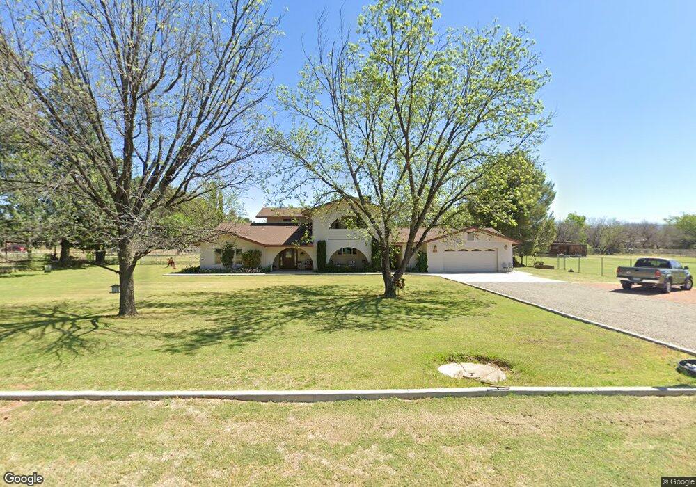
390 W Pheasant Run Cir Camp Verde, AZ 86322
Estimated Value: $784,000 - $986,000
--
Bed
--
Bath
3,568
Sq Ft
$243/Sq Ft
Est. Value
About This Home
This home is located at 390 W Pheasant Run Cir, Camp Verde, AZ 86322 and is currently estimated at $865,279, approximately $242 per square foot. 390 W Pheasant Run Cir is a home located in Yavapai County with nearby schools including Camp Verde Elementary School, Camp Verde Middle School, and Camp Verde High School.
Ownership History
Date
Name
Owned For
Owner Type
Purchase Details
Closed on
Nov 2, 2020
Sold by
Walker Julia A
Bought by
Walker David L and Walker Julia A
Current Estimated Value
Purchase Details
Closed on
Dec 17, 2018
Sold by
Greeson Gary L and Ward Claudia A
Bought by
Greeson Gary L and Ward Claudia A
Purchase Details
Closed on
Oct 8, 2003
Sold by
Flowers Sandra Diane
Bought by
Flowers Douglas T
Purchase Details
Closed on
Dec 13, 2002
Sold by
Corneil Samuel H
Bought by
Greeson Gary L and Ward Claudia A
Purchase Details
Closed on
Jul 13, 1977
Sold by
Edge John N and Edge Margaret E
Bought by
Mccabe James T and Mccabe Marguerite D
Create a Home Valuation Report for This Property
The Home Valuation Report is an in-depth analysis detailing your home's value as well as a comparison with similar homes in the area
Home Values in the Area
Average Home Value in this Area
Purchase History
| Date | Buyer | Sale Price | Title Company |
|---|---|---|---|
| Walker David L | -- | None Available | |
| Walker Julie A | -- | None Available | |
| Greeson Gary L | -- | None Available | |
| Flowers Douglas T | -- | Chicago Title Insurance Co | |
| Greeson Gary L | $120,000 | Chicago Title Insurance Co | |
| Mccabe James T | -- | -- |
Source: Public Records
Tax History Compared to Growth
Tax History
| Year | Tax Paid | Tax Assessment Tax Assessment Total Assessment is a certain percentage of the fair market value that is determined by local assessors to be the total taxable value of land and additions on the property. | Land | Improvement |
|---|---|---|---|---|
| 2026 | $2,793 | $70,091 | -- | -- |
| 2024 | $2,700 | $71,359 | -- | -- |
| 2023 | $2,700 | $60,130 | $7,255 | $52,875 |
| 2022 | $2,545 | $45,494 | $5,349 | $40,145 |
| 2021 | $2,645 | $41,819 | $5,668 | $36,151 |
| 2020 | $2,553 | $0 | $0 | $0 |
| 2019 | $2,498 | $0 | $0 | $0 |
| 2018 | $2,413 | $0 | $0 | $0 |
| 2017 | $2,286 | $0 | $0 | $0 |
| 2016 | $2,198 | $0 | $0 | $0 |
| 2015 | $2,166 | $0 | $0 | $0 |
| 2014 | $2,064 | $0 | $0 | $0 |
Source: Public Records
Map
Nearby Homes
- 1785 S Fort Apache Rd
- 2095 S Hillcrest Dr
- 2050 S Hillcrest Dr
- 1844 S Quarterhorse Ln
- 2045 S Hillcrest Dr
- 1993 S Salt Mine Rd
- 1846 S Dodge Rd
- 1616 S Reeves Arena Rd
- 452 E Cole Blvd Unit 17
- 452 E Cole Blvd
- 955 W Copperhead Rd
- 451 W Salt Mine Rd
- 1703 S Parrish Ln
- 1010 S Clarence Ln
- 469 E Cole Blvd Unit 6
- 356 E Cole Blvd Unit 15
- 328 E Cole Blvd Unit 14
- 405 E Cole Blvd Unit 8
- 437 E Cole Blvd Unit 7
- 270 E Cole Blvd Unit 13
- 380 W Pheasant Run Cir
- 420 W Pheasant Run Cir
- 325 W Fort McDowell Place
- 305 W Fort McDowell Place
- 415 W Pheasant Run Cir
- 350 W Pheasant Run Cir
- 395 W Pheasant Run Cir
- 1898 S Pearl Dr
- 1945 S Pearl Dr
- 1928 S Pearl Dr
- 275 W Fort McDowell Place
- 1938 S Pearl Dr
- 302 W Fort McDowell Place
- 462 W Spruce St
- 335 W Pheasant Run Cir
- 320 W Pheasant Run Cir
- 355 W Pheasant Run Cir
- 270 W Linda Vista Dr
- 255 W Fort McDowell Place
- 1958 S Pearl Dr