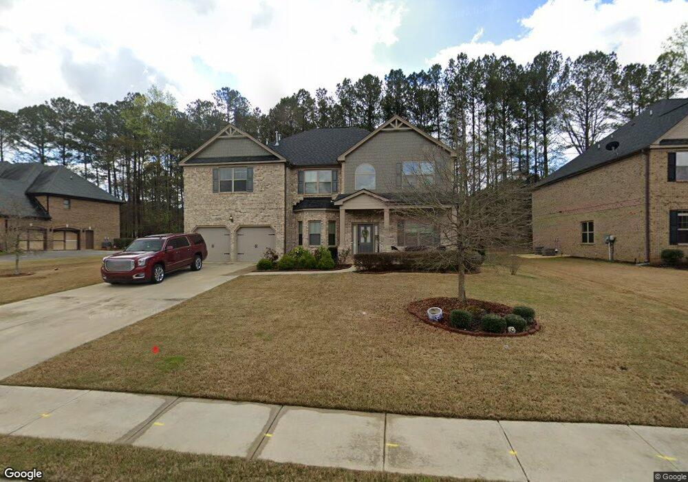
390 Willie Kate Ln Lawrenceville, GA 30045
Estimated Value: $575,350 - $671,000
4
Beds
4
Baths
4,186
Sq Ft
$148/Sq Ft
Est. Value
About This Home
This home is located at 390 Willie Kate Ln, Lawrenceville, GA 30045 and is currently estimated at $620,838, approximately $148 per square foot. 390 Willie Kate Ln is a home with nearby schools including W.J. Cooper Elementary School, McConnell Middle School, and Archer High School.
Ownership History
Date
Name
Owned For
Owner Type
Purchase Details
Closed on
Jun 30, 2016
Sold by
Kevin M
Bought by
Williams Kevin M and Williams Ginina Meshelle
Current Estimated Value
Home Financials for this Owner
Home Financials are based on the most recent Mortgage that was taken out on this home.
Original Mortgage
$310,913
Outstanding Balance
$254,549
Interest Rate
4.4%
Mortgage Type
FHA
Estimated Equity
$366,289
Purchase Details
Closed on
Jan 13, 2016
Sold by
Quinton Crossing Vdl Llc
Bought by
D R Horton Crown Llc
Create a Home Valuation Report for This Property
The Home Valuation Report is an in-depth analysis detailing your home's value as well as a comparison with similar homes in the area
Home Values in the Area
Average Home Value in this Area
Purchase History
| Date | Buyer | Sale Price | Title Company |
|---|---|---|---|
| Williams Kevin M | $316,700 | -- | |
| Williams Kevin M | $316,649 | -- | |
| D R Horton Crown Llc | -- | -- |
Source: Public Records
Mortgage History
| Date | Status | Borrower | Loan Amount |
|---|---|---|---|
| Open | Williams Kevin M | $310,913 | |
| Closed | Williams Kevin M | $310,913 |
Source: Public Records
Tax History Compared to Growth
Tax History
| Year | Tax Paid | Tax Assessment Tax Assessment Total Assessment is a certain percentage of the fair market value that is determined by local assessors to be the total taxable value of land and additions on the property. | Land | Improvement |
|---|---|---|---|---|
| 2024 | $7,627 | $259,160 | $36,000 | $223,160 |
| 2023 | $7,627 | $232,280 | $48,000 | $184,280 |
| 2022 | $6,677 | $216,960 | $43,600 | $173,360 |
| 2021 | $5,443 | $153,360 | $34,400 | $118,960 |
| 2020 | $5,110 | $136,280 | $29,920 | $106,360 |
| 2019 | $4,925 | $136,280 | $29,920 | $106,360 |
| 2018 | $5,136 | $136,280 | $29,920 | $106,360 |
| 2016 | $840 | $15,600 | $15,600 | $0 |
| 2015 | $414 | $10,000 | $10,000 | $0 |
| 2014 | -- | $8,000 | $8,000 | $0 |
Source: Public Records
Map
Nearby Homes
- 400 Willie Kate Ln Unit 7
- 400 Willie Kate Ln
- 380 Willie Kate Ln
- 391 Willie Kate Ln Unit 13
- 391 Willie Kate Ln
- 410 Willie Kate Ln
- 370 Willie Kate Ln Unit 10
- 370 Willie Kate Ln
- 381 Willie Kate Ln Unit 12
- 381 Willie Kate Ln
- 401 Willie Kate Ln Unit 14
- 401 Willie Kate Ln
- 2210 Pirates Cove
- 371 Willie Kate Ln
- 2200 Pirates Cove
- 411 Willie Kate Ln
- 2220 Pirates Cove Unit 1
- 420 Willie Kate Ln
- 420 Willie Kate Ln Unit 5
- 589 Martha Sue Dr