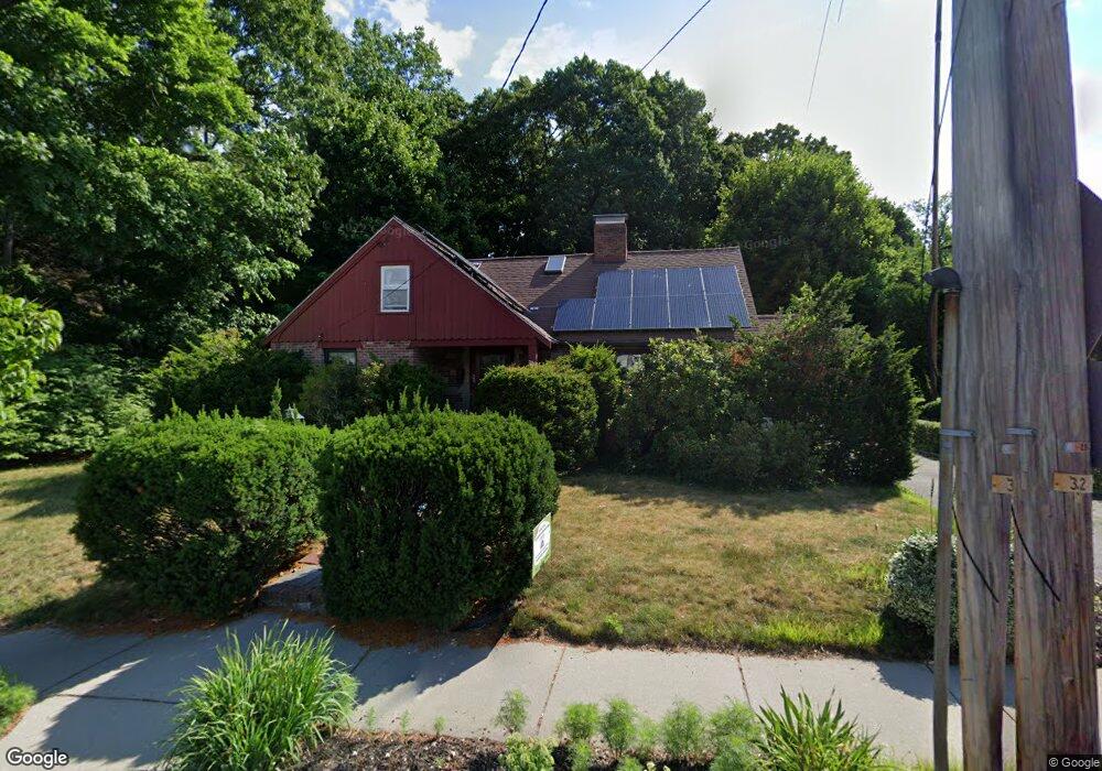
390 Winchester St Newton Highlands, MA 02461
Newton Highlands NeighborhoodEstimated Value: $1,386,000 - $1,643,000
3
Beds
2
Baths
2,287
Sq Ft
$662/Sq Ft
Est. Value
About This Home
This home is located at 390 Winchester St, Newton Highlands, MA 02461 and is currently estimated at $1,513,557, approximately $661 per square foot. 390 Winchester St is a home located in Middlesex County with nearby schools including Countryside Elementary School, Charles E Brown Middle School, and Newton South High School.
Ownership History
Date
Name
Owned For
Owner Type
Purchase Details
Closed on
Sep 30, 1993
Sold by
Barboni Henry J and Johnson Alma R
Bought by
Heeren Timothy C and Lederman Ruth I
Current Estimated Value
Home Financials for this Owner
Home Financials are based on the most recent Mortgage that was taken out on this home.
Original Mortgage
$175,000
Interest Rate
7%
Mortgage Type
Purchase Money Mortgage
Create a Home Valuation Report for This Property
The Home Valuation Report is an in-depth analysis detailing your home's value as well as a comparison with similar homes in the area
Home Values in the Area
Average Home Value in this Area
Purchase History
| Date | Buyer | Sale Price | Title Company |
|---|---|---|---|
| Heeren Timothy C | $235,000 | -- |
Source: Public Records
Mortgage History
| Date | Status | Borrower | Loan Amount |
|---|---|---|---|
| Closed | Heeren Timothy C | $175,000 |
Source: Public Records
Tax History Compared to Growth
Tax History
| Year | Tax Paid | Tax Assessment Tax Assessment Total Assessment is a certain percentage of the fair market value that is determined by local assessors to be the total taxable value of land and additions on the property. | Land | Improvement |
|---|---|---|---|---|
| 2025 | $10,993 | $1,121,700 | $985,700 | $136,000 |
| 2024 | $10,629 | $1,089,000 | $957,000 | $132,000 |
| 2023 | $10,005 | $982,800 | $748,500 | $234,300 |
| 2022 | $9,573 | $910,000 | $693,100 | $216,900 |
| 2021 | $9,237 | $858,500 | $653,900 | $204,600 |
| 2020 | $8,963 | $858,500 | $653,900 | $204,600 |
| 2019 | $8,710 | $833,500 | $634,900 | $198,600 |
| 2018 | $8,221 | $759,800 | $568,400 | $191,400 |
| 2017 | $7,971 | $716,800 | $536,200 | $180,600 |
| 2016 | $7,623 | $669,900 | $501,100 | $168,800 |
| 2015 | $7,311 | $629,700 | $468,300 | $161,400 |
Source: Public Records
Map
Nearby Homes
- 51 Carl St
- 15 Buff Cir
- 36 Roland St
- 128 Charlemont St
- 415 Dedham St Unit D
- 36 Cannon St
- 250 Woodcliff Rd
- 116 Upland Ave
- 183 Oak St Unit 307
- 183 Oak St Unit 205
- 207 Nahanton St Unit 207
- 58 Country Club Rd
- 1 Williams Ct
- 66 Linden St
- 1308 Walnut St
- 1292 Walnut St
- 210 Nahanton St Unit 404
- 19 Selwyn Rd
- 12 Shawmut Park
- 45 Brandeis Rd
- 400 Winchester St
- 386 Winchester St
- 380 Winchester St
- 121 Rachel Rd
- 129 Rachel Rd
- 374 Winchester St
- 395 Winchester St
- 368 Winchester St
- 383 Winchester St
- 401 Winchester St
- 109 Rachel Rd
- 345 Upland Ave
- 337 Upland Ave
- 10 Charlemont St
- 409 Winchester St
- 373 Winchester St
- 11 Sutcliffe Park
- 364 Winchester St
- 0 Goddard St Unit 70712389
- 0 Goddard St Unit 71109869