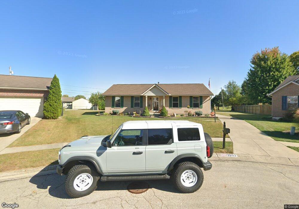
3902 Harris Ln Springfield, OH 45503
Estimated Value: $274,000 - $303,000
3
Beds
2
Baths
1,516
Sq Ft
$191/Sq Ft
Est. Value
About This Home
This home is located at 3902 Harris Ln, Springfield, OH 45503 and is currently estimated at $288,910, approximately $190 per square foot. 3902 Harris Ln is a home located in Clark County with nearby schools including Northridge Elementary School, Kenton Ridge Middle & High School, and Emmanuel Christian Academy.
Ownership History
Date
Name
Owned For
Owner Type
Purchase Details
Closed on
May 20, 2005
Sold by
Groves Damon W and Groves Susan K
Bought by
Groves Damon W and Groves Susan K
Current Estimated Value
Purchase Details
Closed on
Oct 25, 2002
Sold by
Hoppes Builders & Development Co
Bought by
Groves Damon W
Home Financials for this Owner
Home Financials are based on the most recent Mortgage that was taken out on this home.
Original Mortgage
$119,050
Outstanding Balance
$48,566
Interest Rate
6.18%
Mortgage Type
Purchase Money Mortgage
Estimated Equity
$240,344
Create a Home Valuation Report for This Property
The Home Valuation Report is an in-depth analysis detailing your home's value as well as a comparison with similar homes in the area
Home Values in the Area
Average Home Value in this Area
Purchase History
| Date | Buyer | Sale Price | Title Company |
|---|---|---|---|
| Groves Damon W | -- | -- | |
| Groves Damon W | $140,100 | -- |
Source: Public Records
Mortgage History
| Date | Status | Borrower | Loan Amount |
|---|---|---|---|
| Open | Groves Damon W | $119,050 |
Source: Public Records
Tax History
| Year | Tax Paid | Tax Assessment Tax Assessment Total Assessment is a certain percentage of the fair market value that is determined by local assessors to be the total taxable value of land and additions on the property. | Land | Improvement |
|---|---|---|---|---|
| 2025 | $3,492 | $99,390 | $25,340 | $74,050 |
| 2024 | $3,378 | $79,870 | $21,750 | $58,120 |
| 2023 | $3,378 | $79,870 | $21,750 | $58,120 |
| 2022 | $3,390 | $79,870 | $21,750 | $58,120 |
| 2021 | $2,925 | $58,410 | $17,400 | $41,010 |
| 2020 | $2,928 | $58,410 | $17,400 | $41,010 |
| 2019 | $2,983 | $58,410 | $17,400 | $41,010 |
| 2018 | $3,023 | $56,690 | $13,500 | $43,190 |
| 2017 | $2,592 | $51,804 | $13,496 | $38,308 |
| 2016 | $2,574 | $51,804 | $13,496 | $38,308 |
| 2015 | $2,439 | $51,164 | $12,856 | $38,308 |
| 2014 | $2,439 | $51,164 | $12,856 | $38,308 |
| 2013 | $2,382 | $51,164 | $12,856 | $38,308 |
Source: Public Records
Map
Nearby Homes
- 1711 Pinehurst Dr
- 1831 Pinehurst Dr Unit 37
- 1503 Kingsgate Rd
- 1505 Kingsgate Rd
- 1500 Kingsgate Rd
- 1502 Kingsgate Rd
- 1500 Kingsgate Rd Unit 19430
- 1502 Kingsgate Rd Unit 19432
- 1509 Kingsgate Rd
- 1507 Kingsgate Rd
- 3631 Kingsgate Ln
- 4256 Midfield St Unit 9
- 1201 Kingsgate Rd
- 1341 Student Ave
- 1162 Kingsgate Rd
- 4446 Ridgewood Rd E Unit 3
- 3969 Covington Dr Unit 3969
- 4028 Ryland Dr Unit 4028
- 1149 Foxboro Rd
- 3126 Lakeview Ct Unit 3126
Your Personal Tour Guide
Ask me questions while you tour the home.