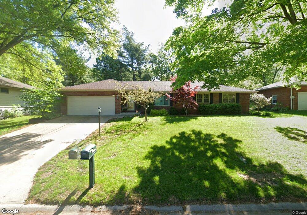
3903 N 29th St Saint Joseph, MO 64506
Northside NeighborhoodEstimated Value: $361,000 - $393,000
4
Beds
3
Baths
3,066
Sq Ft
$123/Sq Ft
Est. Value
About This Home
This home is located at 3903 N 29th St, Saint Joseph, MO 64506 and is currently estimated at $376,107, approximately $122 per square foot. 3903 N 29th St is a home located in Buchanan County with nearby schools including Field Elementary School, Bode Middle School, and Central High School.
Ownership History
Date
Name
Owned For
Owner Type
Purchase Details
Closed on
Dec 16, 2024
Sold by
Smothers Kenneth W and Smothers Theresa M
Bought by
White Cindy F
Current Estimated Value
Home Financials for this Owner
Home Financials are based on the most recent Mortgage that was taken out on this home.
Original Mortgage
$275,000
Outstanding Balance
$270,015
Interest Rate
6.79%
Mortgage Type
New Conventional
Estimated Equity
$106,092
Purchase Details
Closed on
Jul 14, 2006
Sold by
Zimmerman Ellen T and Ellen T Zimmerman Revocable Tr
Bought by
Smothers Kenneth W and Smothers Theresa M
Home Financials for this Owner
Home Financials are based on the most recent Mortgage that was taken out on this home.
Original Mortgage
$0
Interest Rate
6.62%
Mortgage Type
Credit Line Revolving
Create a Home Valuation Report for This Property
The Home Valuation Report is an in-depth analysis detailing your home's value as well as a comparison with similar homes in the area
Home Values in the Area
Average Home Value in this Area
Purchase History
| Date | Buyer | Sale Price | Title Company |
|---|---|---|---|
| White Cindy F | -- | St Joseph Title | |
| Smothers Kenneth W | -- | St Joseph Title & Abstract C |
Source: Public Records
Mortgage History
| Date | Status | Borrower | Loan Amount |
|---|---|---|---|
| Open | White Cindy F | $275,000 | |
| Previous Owner | Smothers Kenneth W | $0 | |
| Previous Owner | Smothers Kenneth W | $104,500 |
Source: Public Records
Tax History Compared to Growth
Tax History
| Year | Tax Paid | Tax Assessment Tax Assessment Total Assessment is a certain percentage of the fair market value that is determined by local assessors to be the total taxable value of land and additions on the property. | Land | Improvement |
|---|---|---|---|---|
| 2024 | $2,375 | $33,200 | $4,850 | $28,350 |
| 2023 | $2,375 | $33,200 | $4,850 | $28,350 |
| 2022 | $2,191 | $33,200 | $4,850 | $28,350 |
| 2021 | $2,201 | $33,200 | $4,850 | $28,350 |
| 2020 | $2,188 | $33,200 | $4,850 | $28,350 |
| 2019 | $2,113 | $33,200 | $4,850 | $28,350 |
| 2018 | $1,908 | $33,200 | $4,850 | $28,350 |
| 2017 | $1,890 | $33,200 | $0 | $0 |
| 2015 | $0 | $31,870 | $0 | $0 |
| 2014 | $1,803 | $28,940 | $0 | $0 |
Source: Public Records
Map
Nearby Homes
- 3815 Miller Rd
- 3028 Ashland Ave
- 3015 Miller Rd
- 2906 Cook Rd
- 3103 Cook Rd
- 3128 Floral Ave
- 3326 Chatham Ave
- 2519 Forest Ave
- 3506 E Lantern Ln
- 3412 N 35th Place
- 3309 Westwood Dr
- 0 Miller Rd Unit HMS2574937
- 3111 N 35th St
- 25 N Carriage Dr
- 3516 Karnes Rd
- 3210 N 36th Terrace
- 00 Lot 2 Highway 169
- 00 Lot 1 Highway 169
- 3805 Grainview Terrace
- 3803 Grainview Terrace