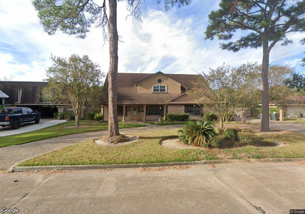
3905 Platt Ave Port Arthur, TX 77640
Estimated Value: $223,000 - $287,000
4
Beds
3
Baths
2,774
Sq Ft
$94/Sq Ft
Est. Value
About This Home
This home is located at 3905 Platt Ave, Port Arthur, TX 77640 and is currently estimated at $261,080, approximately $94 per square foot. 3905 Platt Ave is a home located in Jefferson County with nearby schools including Houston Elementary School, Abraham Lincoln Middle School, and Memorial High School.
Ownership History
Date
Name
Owned For
Owner Type
Purchase Details
Closed on
Dec 21, 2018
Sold by
Nguyen Tony and Nguyen Don
Bought by
Loeza Cruz Rafael and Chavez Josefina Valencia
Current Estimated Value
Purchase Details
Closed on
Nov 16, 2006
Sold by
Sclerandi Glenn V
Bought by
Nguyen Tony and Nguyen Don
Home Financials for this Owner
Home Financials are based on the most recent Mortgage that was taken out on this home.
Original Mortgage
$120,000
Interest Rate
6.08%
Mortgage Type
Purchase Money Mortgage
Create a Home Valuation Report for This Property
The Home Valuation Report is an in-depth analysis detailing your home's value as well as a comparison with similar homes in the area
Home Values in the Area
Average Home Value in this Area
Purchase History
| Date | Buyer | Sale Price | Title Company |
|---|---|---|---|
| Loeza Cruz Rafael | -- | Capital Title | |
| Nguyen Tony | -- | None Available |
Source: Public Records
Mortgage History
| Date | Status | Borrower | Loan Amount |
|---|---|---|---|
| Previous Owner | Nguyen Tony | $120,000 |
Source: Public Records
Tax History Compared to Growth
Tax History
| Year | Tax Paid | Tax Assessment Tax Assessment Total Assessment is a certain percentage of the fair market value that is determined by local assessors to be the total taxable value of land and additions on the property. | Land | Improvement |
|---|---|---|---|---|
| 2025 | $3,925 | $225,710 | -- | -- |
| 2024 | $3,925 | $205,191 | -- | -- |
| 2023 | $3,925 | $186,537 | $0 | $0 |
| 2022 | $5,386 | $169,579 | $0 | $0 |
| 2021 | $5,109 | $213,326 | $9,500 | $203,826 |
| 2020 | $3,764 | $140,148 | $9,500 | $130,648 |
| 2019 | $4,543 | $140,160 | $9,500 | $130,660 |
| 2018 | $393 | $140,160 | $9,500 | $130,660 |
| 2017 | $369 | $150,200 | $9,500 | $140,700 |
| 2016 | $4,400 | $150,200 | $9,500 | $140,700 |
| 2015 | $348 | $150,200 | $9,500 | $140,700 |
| 2014 | $348 | $141,640 | $9,500 | $132,140 |
Source: Public Records
Map
Nearby Homes
- 3901 Platt Ave
- 3911 Platt Ave
- 2600 Willowick Dr
- 3837 Platt Ave
- 3915 Platt Ave
- 2604 Willowick Dr
- 3900 Platt Ave
- 3916 Platt Ave
- 3835 Platt Ave
- 2605 Willowick Dr
- 2608 Willowick Dr
- 2407 Glacier Dr
- 2701 Glacier Dr
- 3923 Platt Ave
- 2611 Willowick Dr
- 3825 Platt Ave
- 2612 Willowick Dr
- 2615 Willowick Dr
- 2705 Glacier Dr
- 2829 Sheridan Ln