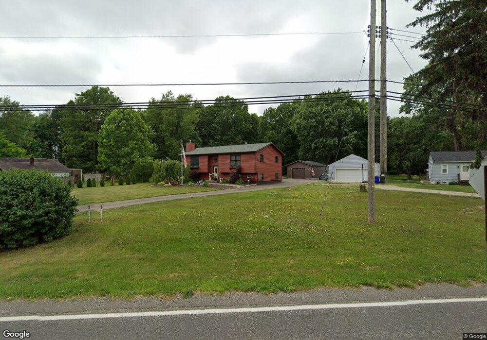
3909 Cook Rd Rootstown, OH 44272
Estimated Value: $258,000 - $361,000
3
Beds
2
Baths
2,135
Sq Ft
$141/Sq Ft
Est. Value
About This Home
This home is located at 3909 Cook Rd, Rootstown, OH 44272 and is currently estimated at $300,475, approximately $140 per square foot. 3909 Cook Rd is a home located in Portage County with nearby schools including Rootstown Middle School - Schnee Building and Rootstown High School.
Ownership History
Date
Name
Owned For
Owner Type
Purchase Details
Closed on
Nov 21, 2008
Sold by
White Rick
Bought by
White Susan
Current Estimated Value
Home Financials for this Owner
Home Financials are based on the most recent Mortgage that was taken out on this home.
Original Mortgage
$98,000
Interest Rate
5.95%
Mortgage Type
New Conventional
Purchase Details
Closed on
Nov 7, 2008
Sold by
White Rick and White Susan
Bought by
White Susan and White Rick
Home Financials for this Owner
Home Financials are based on the most recent Mortgage that was taken out on this home.
Original Mortgage
$98,000
Interest Rate
5.95%
Mortgage Type
New Conventional
Purchase Details
Closed on
Dec 7, 1993
Bought by
White Rick and White Susan
Create a Home Valuation Report for This Property
The Home Valuation Report is an in-depth analysis detailing your home's value as well as a comparison with similar homes in the area
Purchase History
| Date | Buyer | Sale Price | Title Company |
|---|---|---|---|
| White Susan | -- | None Available | |
| White Susan | -- | Lsi | |
| White Rick | -- | -- |
Source: Public Records
Mortgage History
| Date | Status | Borrower | Loan Amount |
|---|---|---|---|
| Previous Owner | White Susan | $98,000 |
Source: Public Records
Tax History
| Year | Tax Paid | Tax Assessment Tax Assessment Total Assessment is a certain percentage of the fair market value that is determined by local assessors to be the total taxable value of land and additions on the property. | Land | Improvement |
|---|---|---|---|---|
| 2024 | $3,513 | $88,130 | $9,800 | $78,330 |
| 2023 | $2,749 | $61,360 | $8,650 | $52,710 |
| 2022 | $2,720 | $61,360 | $8,650 | $52,710 |
| 2021 | $2,723 | $61,360 | $8,650 | $52,710 |
| 2020 | $2,437 | $52,890 | $8,230 | $44,660 |
| 2019 | $2,445 | $52,890 | $8,230 | $44,660 |
| 2018 | $2,218 | $45,570 | $8,750 | $36,820 |
| 2017 | $2,218 | $45,570 | $8,750 | $36,820 |
| 2016 | $2,184 | $45,570 | $8,750 | $36,820 |
| 2015 | $2,209 | $45,570 | $8,750 | $36,820 |
| 2014 | $2,250 | $45,570 | $8,750 | $36,820 |
| 2013 | $2,235 | $45,570 | $8,750 | $36,820 |
Source: Public Records
Map
Nearby Homes
- 3689 Cherry Hill
- 3701 State Route 44
- 0 Lynn Rd Unit 5110102
- V/L 2 Lynn Rd
- V/L Lynn Rd
- 4225 Hattrick Rd
- 4415 Farmette Dr
- 4691 Scenic Dr
- sub lot Lane Ave
- 3637 Old Forge Rd
- 0 Tallmadge Rd Unit 5189301
- 0 Tallmadge Rd Unit 5189314
- 4556 Rootstown Rd
- 3021 Hartville Rd
- 4140 Sandy Lake Rd
- 4058 Bayberry Knoll Ln
- 3925 Summit Rd
- 3080 Saxe Rd
- 4958 Bassett Rd
- 1065 Shadowlawn Dr
- 3919 Cook Rd
- 3903 Cook Rd
- 3927 Cook Rd
- 3899 Cook Rd
- 3904 Cook Rd
- 3922 Cook Rd
- 3937 Cook Rd
- 3904 West Dr
- 3910 West Dr
- 3918 West Dr
- 3928 West Dr
- VL 11.5 Cook Rd
- 3886 Cook Rd
- 3949 Cook Rd
- 0 Cook Rd Unit 4031406
- 0 Cook Rd Unit 4009107
- 0 Cook Rd Unit 3225034
- 0 Cook Rd Unit 3225076
- 0 Cook Rd Unit 3225069
- 0 Cook Rd Unit 3402688
Your Personal Tour Guide
Ask me questions while you tour the home.