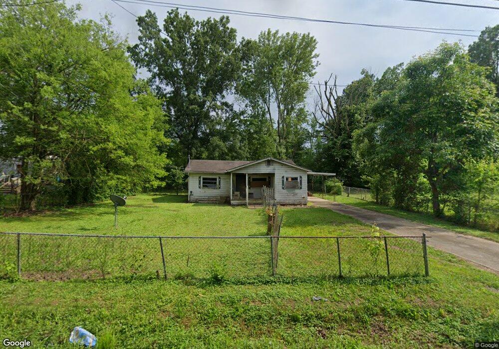
391 Carrol Dr Ringgold, GA 30736
Westside NeighborhoodEstimated Value: $76,597 - $172,000
--
Bed
--
Bath
792
Sq Ft
$160/Sq Ft
Est. Value
About This Home
This home is located at 391 Carrol Dr, Ringgold, GA 30736 and is currently estimated at $126,399, approximately $159 per square foot. 391 Carrol Dr is a home with nearby schools including West Side Elementary School, Lakeview Middle School, and Lakeview-Fort Oglethorpe High School.
Ownership History
Date
Name
Owned For
Owner Type
Purchase Details
Closed on
Aug 19, 2019
Sold by
Brewer Michelle
Bought by
Roman Angel Castrejon and Cesena Ricardo
Current Estimated Value
Purchase Details
Closed on
Jul 23, 2019
Sold by
Ayers Janice
Bought by
Brewer Michelle and Brewer Chad
Purchase Details
Closed on
Mar 8, 2012
Sold by
Mcneese Ernest W
Bought by
Mooneyhan Kim
Purchase Details
Closed on
Jun 9, 2009
Sold by
Mcneese Wayne
Bought by
Ayers Janice
Purchase Details
Closed on
Sep 13, 1991
Bought by
Mcneese Wayne
Create a Home Valuation Report for This Property
The Home Valuation Report is an in-depth analysis detailing your home's value as well as a comparison with similar homes in the area
Home Values in the Area
Average Home Value in this Area
Purchase History
| Date | Buyer | Sale Price | Title Company |
|---|---|---|---|
| Roman Angel Castrejon | $10,000 | -- | |
| Brewer Michelle | -- | -- | |
| Mooneyhan Kim | $20,000 | -- | |
| Ayers Janice | $24,000 | -- | |
| Mcneese Wayne | $16,000 | -- |
Source: Public Records
Tax History Compared to Growth
Tax History
| Year | Tax Paid | Tax Assessment Tax Assessment Total Assessment is a certain percentage of the fair market value that is determined by local assessors to be the total taxable value of land and additions on the property. | Land | Improvement |
|---|---|---|---|---|
| 2024 | $113 | $5,276 | $4,500 | $776 |
| 2023 | $108 | $5,060 | $4,500 | $560 |
| 2022 | $110 | $4,930 | $4,500 | $430 |
| 2021 | $103 | $4,930 | $4,500 | $430 |
| 2020 | $111 | $4,812 | $4,500 | $312 |
| 2019 | $259 | $11,060 | $4,500 | $6,560 |
| 2018 | $236 | $9,560 | $3,000 | $6,560 |
| 2017 | $242 | $9,794 | $3,000 | $6,794 |
| 2016 | $241 | $9,282 | $3,000 | $6,282 |
| 2015 | -- | $9,282 | $3,000 | $6,282 |
| 2014 | -- | $9,282 | $3,000 | $6,282 |
| 2013 | -- | $10,870 | $4,588 | $6,282 |
Source: Public Records
Map
Nearby Homes
- 35 Karen Dr
- 354 Karen Dr
- 27 Templin Hills Ln
- 137 Winchester Dr
- 98 Winchester Dr
- 72 Lillian Dr
- 27 May St
- 302 Huntley Meadows Dr
- 385 Winchester Dr
- 5 Winchester Dr
- 398 Winchester Dr
- 792 S MacK Smith Rd
- 618 Larry Dr
- 527 Winchester Dr
- 530 Winchester Dr
- 518 Winchester Dr
- 615 Larry Dr
- 162 Huntley Meadows Dr
- Peyton Plan at The Fields at Huntley Meadows
- Quail Run Plan at The Fields at Huntley Meadows
- 377 Carrol Dr
- 0 Carrol Dr Unit RTC2731596
- 323 Carrol Dr
- 0 Carrol Dr Unit 1253952
- 0 Carrol Dr Unit RTC2323595
- 0 Carrol Dr
- 374 Carrol Dr
- 414 Carrol Dr
- 431 Carrol Dr
- 362 Carrol Dr
- 339 Carrol Dr
- 371 Karen Dr
- 371 Karen Dr Unit 371
- 359 Karen Dr
- 331 Karen Dr
- 325 Karen Dr
- 328 Carrol Dr
- 325 Carrol Dr
- 385 Karen Dr
- 399 Karen Dr